
Mad River Notch Loop
What had concluded following hours of reading old hiking forums, and scrutinizing trail maps for distance calculations and elevation profile was that there remained an infrequently navigated loop in the Waterville Valley region of the White Mountain’s which saw predominately multi-day backpacking traffic; My plan was to move quick and light through the mountains, covering the 17-mile loop in one day.
Known as The Mad River Notch (loop), hikers traverse up and over Mount Tecumseh, navigate over to and down the Greeley Ponds Trail, then trek the Mount Osceola Trail end-to-end, over both East Osceola and Mount Osceola before connecting the loop with an easier stroll along Tripoli Road - seemed simple enough, on paper at least.

Soft paths along the Mount Tecumseh Trail
As the Mount Osceola Trailhead lays essentially at the height-of-land in Thornton Gap along Tripoli Road, I used that to my advantage, the 1.2-mile jog would be a warm-up for the lungs and legs amidst the 7:06am start. Tripoli Road was minimally exciting - just a dirt forest road which meanders through a beautiful forest; no other vehicles were out to break the silence of the cool morning air.
Through a lush, green forested canopy I departed the Mount Tecumseh Trailhead and almost immediately made a long leap across Eastman Brook, while several of its nearby tributaries could be crossed on exposed roots and rocks. The old logging road turned footpath was soft and enjoyable for a morning climb, dodging exposed roots I began the long ascent up to gain the northwest ridge.
I recall at nearly every step through this wilderness, in utter disbelief at how enjoyable the forest ramble really was; between the fallen conifer needles underfoot to the sweet scent of evergreen resin lingering in the air, here contained a level of remoteness I had yet to experience in the White Mountains: no nearby ski resort traffic, no heavily eroded footpath; aside from the trail underfoot - nothing manmade in sight.

Nearing the summit of Mount Tecumseh
At the finish of a 1,800’ climb up the north-facing slope of Mount Tecumseh, the path swings to briefly follow several topographical bumps along the west ridge; as elevation is gained, several restricted views could be found through the dense tree growth, given the low cloud ceiling of the autumn morning I continued toward my first summit.
Reaching the edge of the west ridge, the trail meets up with the old 1939 fire break, which would have descended here, along the northern ridge before tracking atop the Osceola ridgeline toward East Osceola. After dropping down 150’ into the col, which had a few lingering puddles this morning, the path climbs 400’ to reach the high point of Mount Tecumseh at 4,003’.

Summit views atop Mt Tecumseh
On a clear sky day, good views out to the Osceola’s and Tripyramids can be had from Tecumseh’s north-facing outlook. Footing becomes increasingly rough and rugged upon cresting the mountain and beginning the descent down its eastern slope. Making a clockwise swing around the summit cone, the trail eventually meets up with the Sosman Trail, but not before several short and steep, bouldery downclimbs.
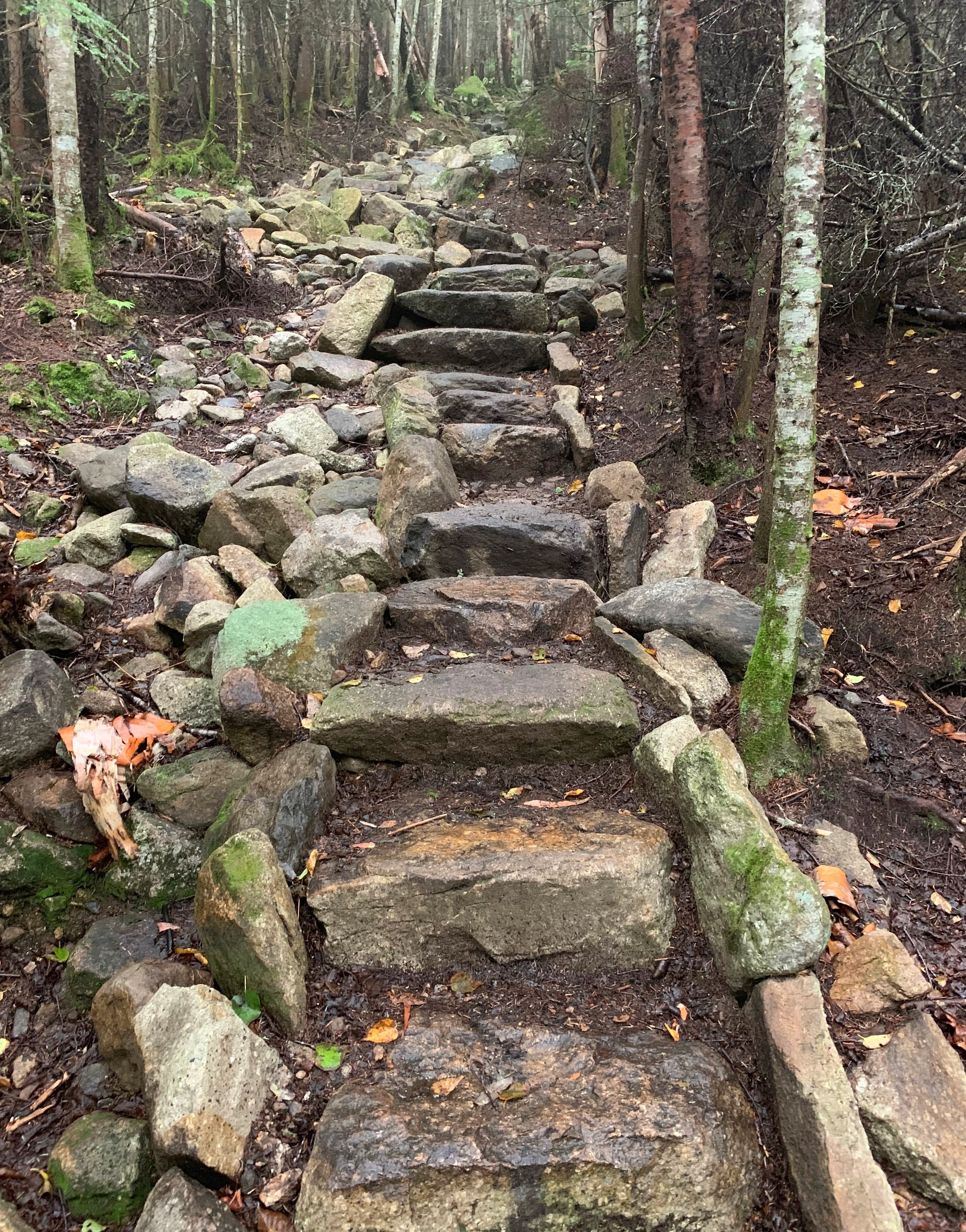
For 0.1-mile, the Sosman and Mount Tecumseh trails coincide before splitting, the Sosman Trail proceeds right, toward the top of the ski resort as the Mount Tecumseh trail veers left, at which point it immediately begins a steep descent. Atop perhaps one of the longest continuous rock staircases in the White Mountains, the path follows the route of an old logging road, interesting views out beyond the tree canopy can be found as the trail nears the ski trails.
Descending Mt Tecumseh
At 0.9-miles from departing the flat ridgeline, the trail meets up with the old (pre-90’s) trail, which now provides a short spur out to the ski slopes where one can find a breath-taking panorama of the Tripyramids. In an effort to route the Mt Tecumseh Trail off active ski slopes, in 1991, the trail was relocated near its current location, into the woods.
A couple of steep, tight switchbacks brings hikers across Tecumseh Brook; a pleasant ravine in the hillside in which to pause momentarily before climbing back up the far side of the gully to continue the easterly descent. Lovely patches of spruce are passed before the forest opens up to a hardwood mix further down the hillside.

Easterly views from Waterville Valley Ski Resort
Crossing Tecumseh Brook once again, the trail enters a relocated stretch from Hurricane Irene flooding (2011), before crossing a final, smaller brook atop small rocks and entering the Waterville Valley Ski Resort parking area. Navigating around the exterior of the lots, I soon diverged onto the grassy Pipeline Trail which would be followed further east, to eventually join the Tripoli Road south.
Reaching the turn-off for the Livermore South Trailhead parking lot, I veered right to follow the wide track of Livermore Road (Forest Road 53). At 0.3-miles into Livermore Road, the old Depot Camp clearing is reached. Just beyond the first brook crossing, the spaciously wide Greeley Ponds Trail departs on the left.

Soft paths of Greeley Ponds Trail
Tracking generally northerly toward the upper and lower Greeley Ponds, several re-routes are passed while trekking atop the curiously new crushed stone footing; more damage from Hurricane Irene, which even closed the trail for a short time until repairs or relocations could be made to the trail bed and several bridges along the route.
The pathway remains soft underfoot via a well-graded stone and gravel surface; hopefully this trail will last well into the future as it is a pleasure to traverse. Lady slippers, various ferns and (depending on the time of the year), young striped maple lined the scenic Greeley Ponds Trail.
While the pathway tracks near-level along the western shore of Mad River, the Goodrich Rock Trail is encountered, which diverges west (left). As this side path was not on today’s itinerary but have ventured down in the past, I suggest, if time allows - do not pass up the opportunity to trek amongst some of the largest glacial erratics in the state! The upper path is much like meandering around towering prows found in a busy shipyard. A tall ladder even guides climbers atop Goodrich Rock, which affords a stunning lookout toward the Sandwich Range.

More soft paths of the Greeley Pond Trail
Back in the 1960’s, the Greeley Pond Trail was reported to have been passable by vehicles for the first 1.1-mile (from the south), beyond which was footpath. This area must be nearby as the newer path now continues toward the north, swinging gently around the base of East Osceola and one of its southern sub-peaks. According to old maps and reports, before the hurricane damage and rerouting projects, the path used to cross Mad River 0.1-mile prior to where the now abandoned Flume Trail enters (trail followed south of Flume Brook).
At 9.0-miles from the Mount Osceola Trailhead of this morning, another interesting side-path is reached; Timber Camp Trail is a lovely path which becomes densely forested as one ascends, a fir corridor brings hikers to a peculiar sand and gravel bank. Interesting vistas around the Mad River Notch welcome and await explorers.

A network of roots
Following old logging roads beyond the Timber Camp Trail spur, this rerouted stretch soon approaches a hairpin turn, turning toward the east to descend and cross Greeley Brook and the Mad River atop loose, sandy footing. Beyond the bridged Mad River crossing, the trail parallels the eastern side of the waterway for 0.8-miles before crossing the waterway once again, thus tracing along the west shore of the ponds.
While the trail is somewhat elevated from the shore of the pond, it passes through a beautiful forest atop a highly enjoyable stretch of pathway; while stepping over exposed roots it is possible to glimpse down through the trees toward the rippling surface of the ponds.

Upper Greeley Pond
Reaching the southern terminus of Upper Greeley Pond brings us to the location of the old Mount Osceola Trail; crossing and following near to the route of an old slide, the trail was “unusually steep” and dangerous in wet weather. Rerouted in the late-80’s, the new path tracks along the north ridge of the East Peak.
Along the serene and secluded Greeley Ponds, several short spur paths can be found which bring hikers down to water-level. Passing the ski route several times, the trail becomes wet and lightly washed-out in areas just north of the upper pond, bridges help in several instances across inlets and drainages. A large glacial erratic is passed mid-trail on the journey to reach the newer Mount Osceola Trail terminus.

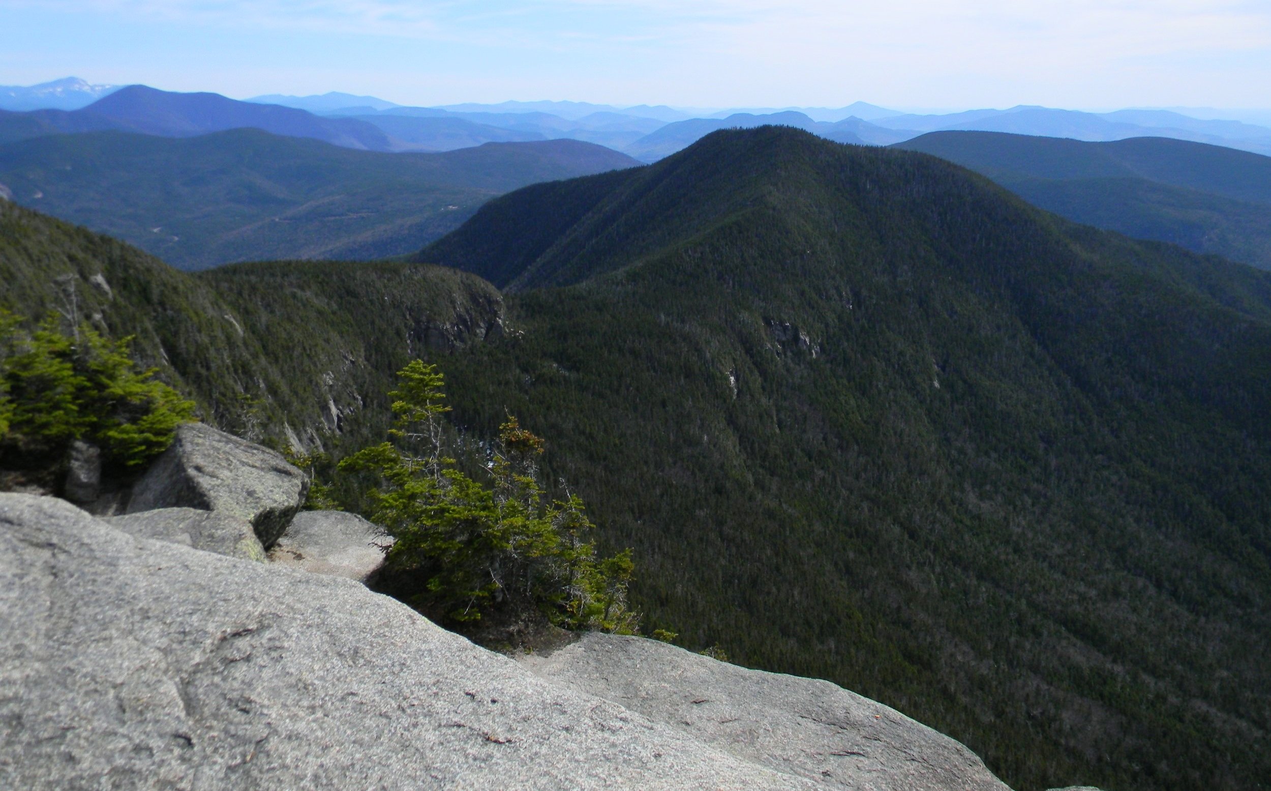
Cliffs of Huntington, Arrow Slide of Hancock, Signal Ridge of Carrigain
What begins as a moderately rocky ascent soon becomes impressively steep as the trail climbs the north ridge beneath a sheer cliff-face. While unrelenting, the ascent tracks diagonally across a ledgy slide which features a beautiful lookout to Upper Greeley Pond and the Mount Kancamagus (3,762’) ridgeline.
Before cresting onto the ridgeline itself the rugged trail ascends through a chute of loose rock, climbing a dizzying pitch before tapering off to a more palatable grade; atop the steep ascent (when the path continues left), a short spur path affords a good lookout. Once atop the ridgeline, the path gradually finishes its ascent through an evergreen corridor, finally swinging westerly, toward the wooded summit.
East Osceola from the main summit
A large stone cairn marks the high point of the mountain, beyond which the Mount Osceola Trail follows another west-facing ridgeline, making a rocky descent toward the final peak - Mount Osceola. Nearing the col, a lookout is passed which offers a glimpse of Mount Osceola and along Scar Ridge.
The path quickly reaches a notoriously steep, precipitous scramble known as “the chimney”, precisely what it is; while it is best used for ascending, there is also an optional detour to the north, which is best suited for those descending the steep, rocky face. Employing both hands and feet to scramble up the tight, ledgy cleft, the two paths merge at the top, offering a stunning look back toward East Osceola.
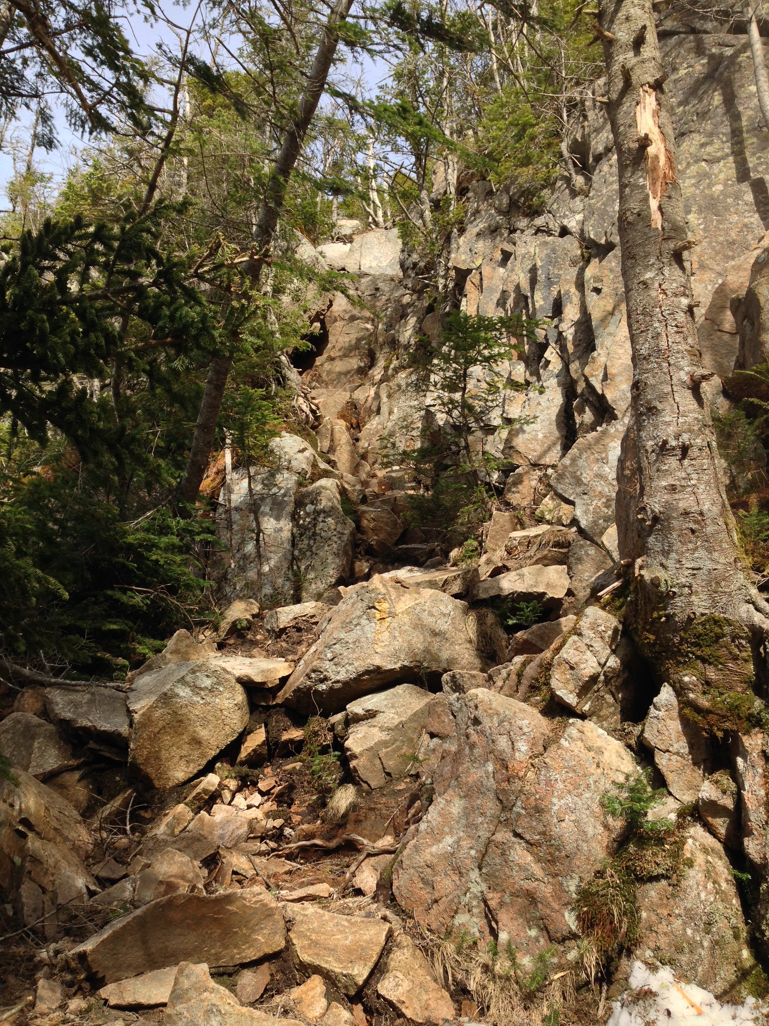
The Chimney on Mt Osceola
With a long, more gradual ascent, the trail climbs the final 200’ to reach the bare-topped summit, atop which a fire tower stood until 1985. Today, mere concrete foundations can be found along its bare summit rocks; a US Geological Survey bench mark disc can also be found. The summit ledges form several levels in the ledgy mountaintop, affording many alcoves and secluded places in which to take in the amazing panorama.
Departing the high point of the loop, as the descending path begins a long string of switchbacks, a spur path can be discerned which vaguely guides hikers toward Middle and West Osceola. The upper trail slabs along the bedrock in many places, crossing several wet patches as water drains downslope, and looses considerable elevation before joining and descending atop the Breadtray Ridge.
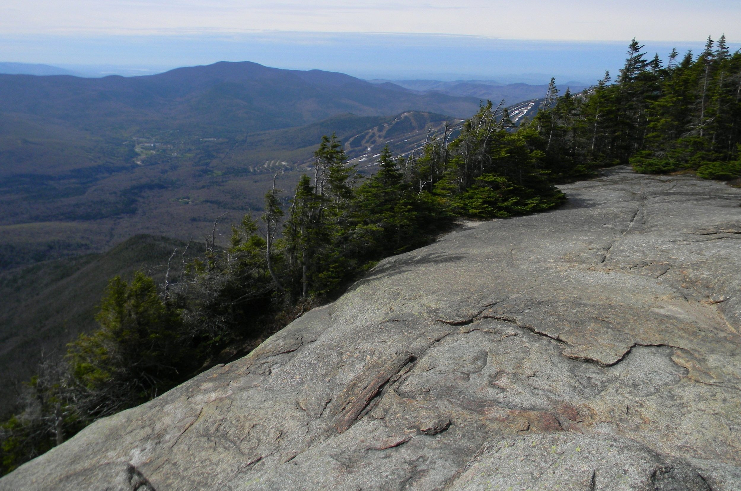
Waterville Valley + Sandwich Range
The trail transitions from one of packed dirt and rock along the switchbacks to a very rugged path as the grade tapers; here, I practice the art of “rock walking”, which was an encouraged practice back in the Adirondacks - to walk atop rocks in places of mud or soggy trail. The skill comes in extremely handy as the path resembles a boulderfield in many instances during the lower descent, however, it levels out to a well-graded pathway as one nears the large trailhead.
Taking a moment before tumbling into the drivers seat, I reminisced on all the beautiful places I had visited today; countless steep, craggy ascents, loads of brilliantly colored flora while out exploring the Mad River Notch. I think next time I visit these trails, with their endless side paths and places of interest, I’ll plan on a much longer stay in this beautifully remote neck of the wilderness.
Overall stats for the day:
17.07-miles
4hr 24 minutes
5,787’ elevation gain
Mount Tecumseh - 4,003’
Mt Tecumseh NW Peak - 3,766’
East Osceola - 4,156’
Mount Osceola - 4,320’

Survey bench mark disc atop Mt Osceola