
Black Mountain: Chippewa Trail
With clear skies and low wind in the forecast, a late-spring ascent of Black Mountain is never a bad idea. While a southward trek from Benton, would afford a much gentler grade, the Black Mountain Trail offers minimal reward in the way of views until one reaches the open summit ledges. Along a much more rugged pathway in its upper sections, the Chippewa Trail, beginning southwest of the mountain, provides glimpses along the western horizon and surrounding mountainscape all throughout the final 0.6-mile trek up to the bare summit.

Along the Chippewa Trail
The Chippewa Trailhead and dirt parking lot area can be found on the eastern side of Lime Kiln Road in Haverhill, NH; the lot can accommodate perhaps 6 vehicles with room for several more along the shoulder of the dirt road. What was once known as the Southwest Trail of Black Mountain, in AMC Mountain Guidebooks until 1946, was henceforth named the Chippewa Trail, likely for Camp Chippewa, which once stood nearby. The camp, set up for unemployed transients, was converted into a girl’s camp following 1937, a year later the government transitioned the camp into a Civilian Conservation Corps base camp.
Nowadays, the Chippewa Trail utilizes the mellow grade of old logging and woods roads until beginning a steep climb up the southwestern shoulder of the 2,820’ peak. Once the pathway departs the lower hillside, it climbs steep briefly, with occasional loose footing; other times, the path winds atop bare granite ledges while stretching toward the open summit. While meandering through a series of small switchbacks, the path slices through a stunning conifer forest, with a brief patch of unforgettable red pine.

Onto the old logging roads
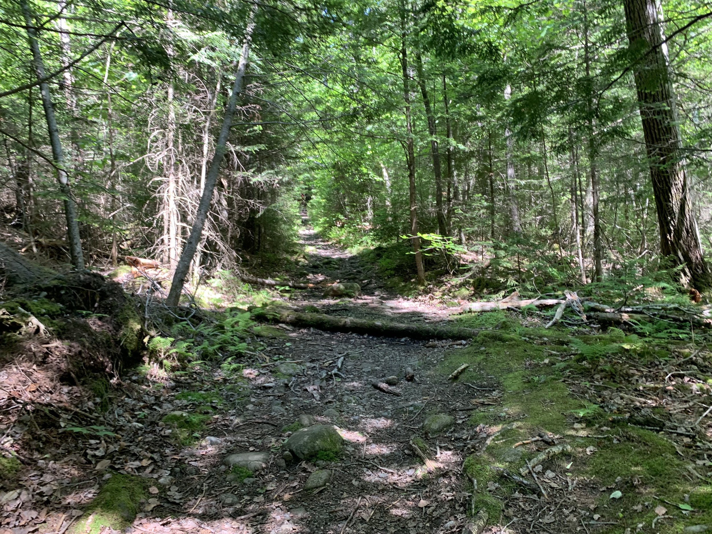
Beginning out of the northwestern corner of the trailhead parking lot (near the road), the Chippewa Trail almost immediately begins descending earthen steps in the hillside which are framed by large logs, most of which are showing wear from years of spiked boots. Into a boggy sag, the trail dips quickly into a wet area, passing several small brooks atop steppingstones and plank boardwalks. In winter, southeasterly views can be found here, toward the neighboring low knob of Sugarloaf Mountain, unfortunately the canopy had grown in thick by this late-June jaunt, mostly obscuring any hint of a view of surrounding mountains at this low elevation.
Rolling along several short, steep patches, which require using spruce roots as steps, the Chippewa Trail crests up a bank and emerges onto an old logging road. Trailside signs indicate the trail’s direction: the Chippewa Trail continues eastward (right) while the short spur path toward the old lime kilns can be found to the west (left).

Entering Kingsbury Timber-Chippewa Trail Forest
The main pathway is marked with several painted and pointed “Trail” signs at junctions, but care should be taken locating the correct footpath as several other old logging roads also diverge nearby, both of which are brushy and becoming grown-in with grasses but may become more confusing and problematic in wintertime.
A gradual 0.2-mile ascent brings hikers to the large sign which announces their entry to the Kingsbury Timber-Chippewa Trail Forest; a 168-acre area of forest land, protected by the Forest Society (SPNHF, or the Society for the Protection of New Hampshire Forests). For the coming 0.3-miles, the Chippewa Trail ascends steadily atop an old logging road, which has become moderately eroded over the years, now appearing like a streambed with rounded river rocks comprising the surface.
Ascending more old forest roads
Overall footing and travel are easy and solid on this near-straight stretch which leads eventually to the site of an old farm pasture, now growing in with small diameter, pencil-straight saplings. Trailside, old foundation walls can be found on the right while ascending; shortly beyond, the old Southeast Trail could once be found, parts of which I may have located and traversed in wintertime while bushwhacking the northern aspect of Sugarloaf Mountain from this location.
Beyond the patch of dense, new growth, the forest once again opens back up to a more mature canopy, conifers now abound as their dropped needles soften the footpath. Ascending steeply initially, well-placed rocks act as both stone steps and work to retain the steep hillside. In many places the trail also resides in a well-worn, deep trench.

Beginning the ledgy ascent of the Chippewa Trail
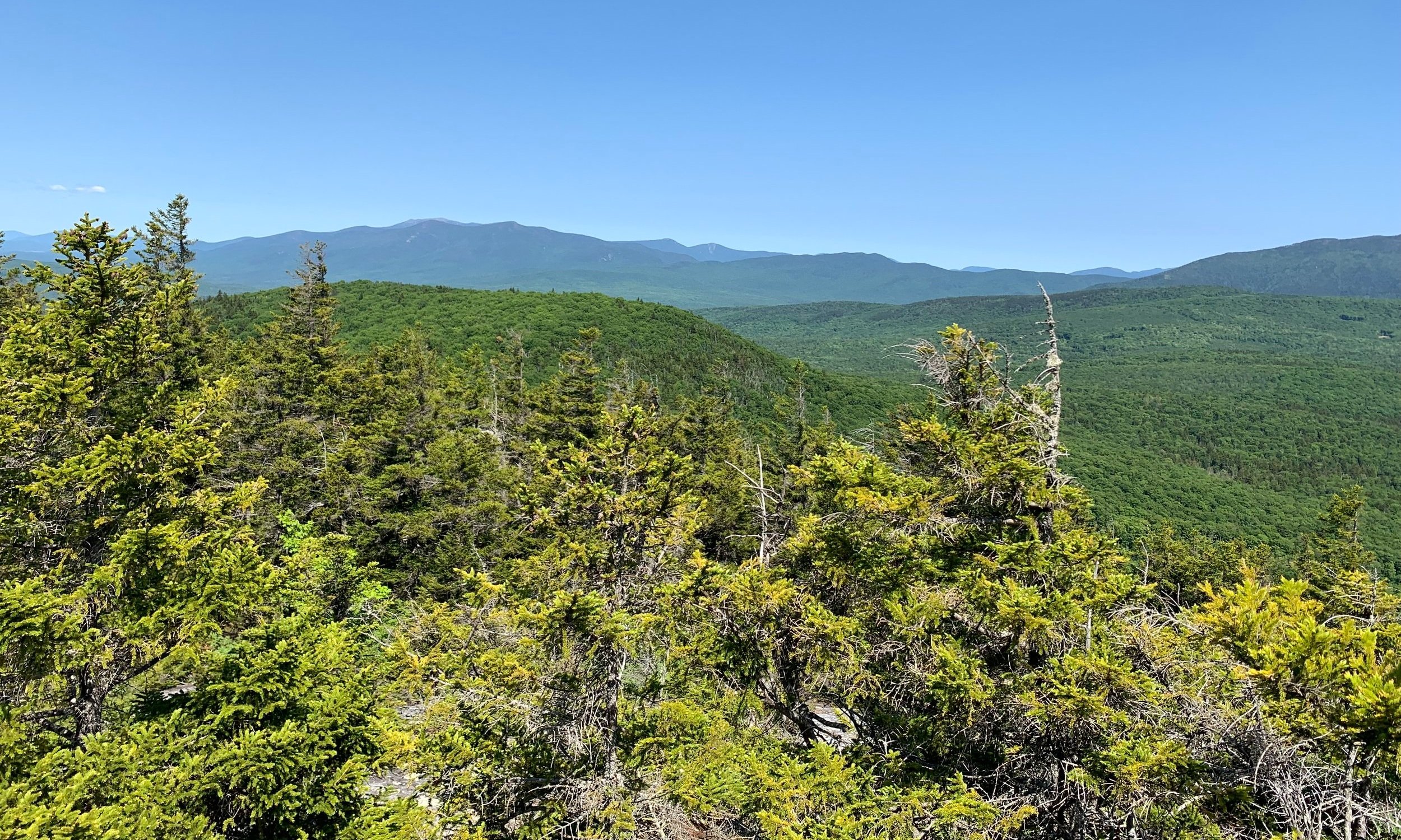
Nearing a beautiful grove of red pines, evidence of many winding paths switchback up the steep grade, exposed roots stick out through the duff and conifer needle floor. Emerging at the first open ledge area, a taste of views to come can be had; Signal (3,360’), Butterfield (3,167’) and Knox (3,086’) Mountains of Vermont dominate the wide, westward panorama.
Following the yellow blazes, the path crosses a short, wet spot atop several steppingstones before cutting through a sea of evergreen, while climbing steep pitches of bare bedrock, low blueberry bushes can be seen at ankle-height; today, the soon-to-be blueberries were found still green, perhaps they may be found edible late-July or August, at these mountainous elevations.

Southeasterly views from Black Mountain
Massive rock emerges from the forested hillside, occasionally ascended by the trail; finally, at 1.8-miles, the Chippewa Trail emerges from the forested canopy and onto a large set of rocky ledges. From here, countless peaks can be picked out - perhaps the best of all is the glimpse east, toward the summit and final mountaintop ledges of Black Mountain; these ledges can be reached by a short herd path leading southwestward from the summit area.
Once the breeze and breath-taking views have been taken in, it is time for one last dip into the dense forest. The path swings northward, around a steep scramble up bare rock, which is evidently a place for off-trail scramblers to try their hand at low-angle rock climbing, judging by the herd path which is now being formed through the mosses and greenery.

Westerly views of Vermont peaks
Continuing the clockwise swing around the craggy summit area, the Chippewa Trail reaches the Black Mountain Trail junction, which departs out of Benton, and passes an old stone campfire ring; no doubt low-impact camping at this already established site would afford spectacular sunrises over the Franconia Ridge.
A final, brief scramble up to the 2,820’ bare summit opens to a massive panorama from the Kinsmans to Moosilauke and the rest of the southern Benton Range, toward the lesser prominent Connecticut River Valley Mountains and onward into Vermont - today, Mount Ascutney (3,130’) could be seen cutting through a slight atmospheric haze.
Kinsmans + Franconia Ridge over nearby Howe Hill
The side spur trail which ventures southwesterly, toward more open ledges, primarily features peaks of Vermont while high peaks of the New York Adirondacks can certainly be picked out, should the atmosphere prove agreeable on the day Black Mountain is hiked.
Retracing steps through a narrowing in the scrappy mountaintop conifers, back along the summit ridge, evidence of the old fire tower is all but erased. Erected and staffed from 1911 until 1964, the tower was finally removed in 1978, likely the ranger cabin just below the summit area was deconstructed around the same time.

Junction below the summit crest
With the luck of good weather, I thought of searching for the reknown Tipping Rock. Heading east/northeast from the summit of Black Mountain, there are several faint herd paths and ledgetops to skirt along. Discovering one large glacial erratic - which appeared to have tumbled to a resting point - I called off my searching at this point while soaking in a stunning view of Franconia Ridge, which was not completely visible from the high point of Black Mountain. Consulting maps and prior tracks, it would appear I had not ventured far enough along the summit ridge - trekking further toward the next set of open ledges would have brought me to the actual Tipping Rock - next time perhaps!
Once the views and blue skies were soaked in, water and snacks consumed to satisfaction, the same Chippewa Trail was descended with care due to much loose footing: sand, scree and pine needles all threatening to slide downslope. When the blue-blazed State Forest property line is encountered, there are several side spur paths which diverge eastward with reportedly good vistas from each ledgy area; with other objectives in mind, these were not visited today.
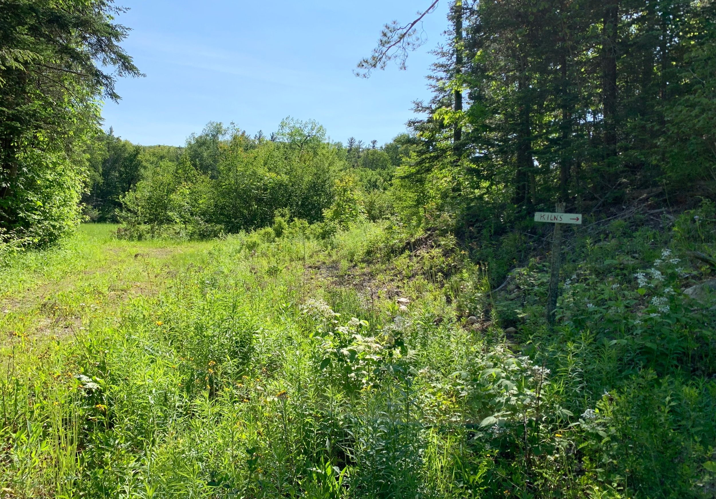
Signs lead down old forest roads to the ancient kiln area
Back along the main (initial) logging road, several signs can be found indicating the direction in which to locate the old lime kilns. Constructed in 1839 and 1842, these old kilns were used to render powdered lime from the nearby stone. The final product would be packed into barrels and shipped along the nearby Concord, Boston and Montreal Railroad, eventually being used for agricultural purposes as well as an important additive for mortar at the time.
Being productive enough to warrant a nearby school for the employee’s families, the source of lime was stated to be among the finest quality and of an inexhaustible supply yet remained in use for only 50-years. The main kiln which is now the showpiece of the dead-end trail was restored by CCC efforts in the 1930’s. The historical kilns and surrounding area are all located on private property whose owner generously allows public traffic; care should be taken to avoid littering or becoming a nuisance on the private land.
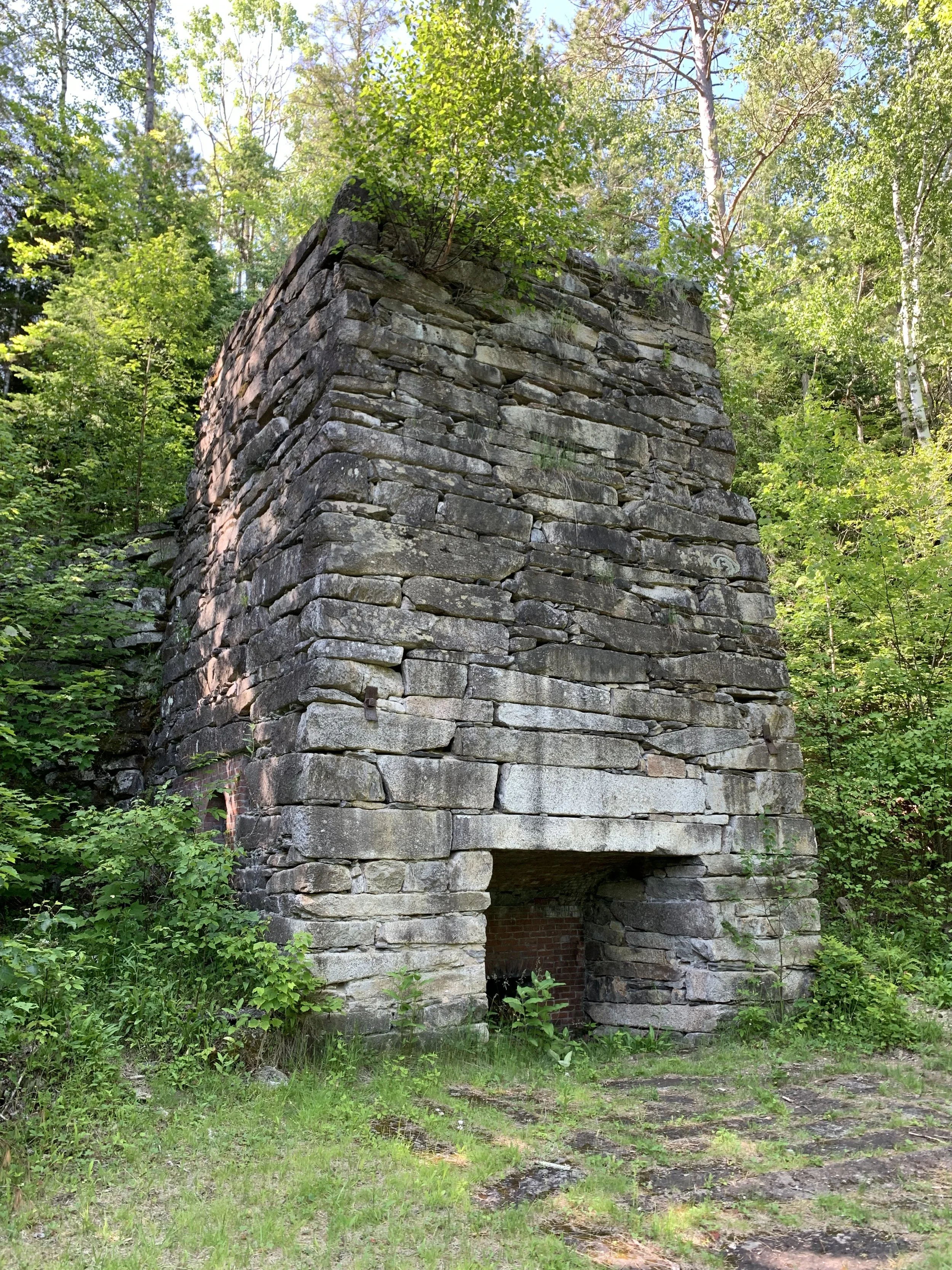
One of the massive lime kilns
All around can be found beautifully constructed stone benches and walls, another addition by the skilled Civilian Conservation Corps workers during the Depression era.
While occasional ticks can still be found amongst the tallest blades of grass, desperately wanting latch onto one’s bare skin, thankfully a vast majority of the biting bugs (mosquitoes and black flies) have subsided for the season, turning the large clearing at which the kilns can be found into a beautiful resting area. If one glimpses northeasterly through the encroaching verdant canopy, the upper crags of Black Mountain can also be seen.
Once the joy of a beautiful day has been fully absorbed, the narrow pathway can be followed back, passing the brushy remains of the older kiln, which soon opens to a wider forest road, guiding one’s way back to a right turn (once past the private property), down a small embankment and back along the low, boggy lands toward the Chippewa Trailhead, from whence the adventure began.
Overall stats for the day:
3.95-miles
2hr 32 minutes
1,804’ elevation gain
Black Mountain - 2,820’