
Sonoma Peak
From a deep, restful slumber following nearly ten hours climbing on Mount Shasta I awoke to a banger of a party coming from the SUV across my parking lot campground - high beams and bass both directed my way.
The time was 3:30am and with another blue sky, low wind forecast and low avalanche risk, time had come once again to get rolling down the dusty path back to friendlier gas prices and the next on my Cascade Volcano to-do list.
To make my long story longer, Mt McLaughlin was a failed attempt due an unplowed National Forest Road #3661, ending several miles from the trailhead. Once backtracked to a secondary approach to the mountain I found myself in a beautiful forest along the Pacific Crest Trail but greeted with crotch-deep old post holes and rotten, late-season snow underfoot.

Pacific Crest Trail; Fremont-Winema National Forest, Oregon
I tried to look at the bright side and be happy enough that I was again returning uninjured and ready for something altogether new. For the first time of my road trip I sat there, unsure of whether I should stay on the west coast or begin my long trek east, back toward home. I searched to find what my heart craved, beginning to feel lost and alone.
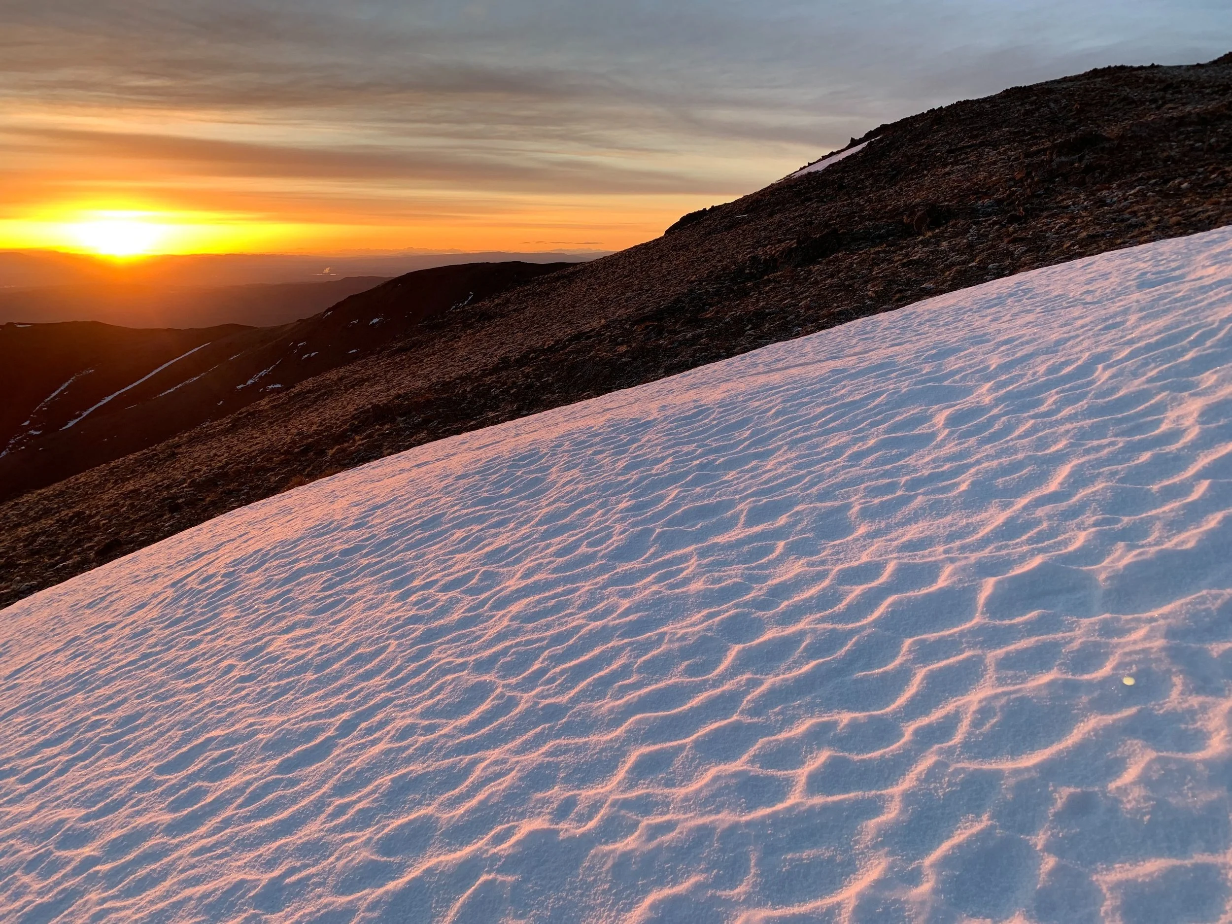
I figured, perhaps after several lows something exciting would again come around. No doubt Mts Hood & Shasta would be hard to top during the remainder of my journey - all I had to do was make smart, safe decisions and I would find more places to love.
After fueling up the Subaru for the coming miles, I pointed my car east and gassed it onto Route 140 in Klamath Falls, Oregon - I was going home.
As the miles ticked by I gawked at the mountains. Huge ranges stretching from north to south - I wanted so badly to be out making memories anywhere in each white-capped range but it was all so new to me, I didn’t know where to begin. Finally, hours into my drive east I needed to consider a place to rest for the night. Ahead in the distance was a mesmerizing mound which rose from the surrounding plateau, I was now in Winnemucca, Nevada.

Sunset in Water Canyon Recreation Area
Upon consulting my AllTrails app I could see a network of trails up on the ridgeline and several camping spots along the way. Exiting the bustling downtown by way of dirt road (with the town Sherriff tailing close behind) I casually made my way into Water Canyon Recreation Area - this seemed promising and I remained hopeful of new adventures.
Assuming this popular hiking area would have zero vacant camp spots, I pulled into the first that had a vault toilet near by. Here, I met Dreamer and Katie, who were setting up a tent and taking a break along their own hiking and climbing excursion; they reluctantly agreed I could park there as a last resort.
Continuing down the Water Canyon Road, I swung through birch groves as the snow-topped ridge towered above. With camp sites available I pressed my luck leaving each behind in hopes that I could score the perfect site closer to a trail.

Sunrise on Sonoma Crest Trail looking to Water Canyon
With prayers answered I found two open sites and a vault toilet across the road, I had my pick. Choosing the shaded site around a bend in the road I backed in just in time for the orange and pink sunset to shine off the white-capped mountains, 2,300’ above.
I had a picnic table, a stream out back, a vault toilet, my own free and legal camp spot (for 3 days at a stay) with near by trails and mountains to run in the morning - finally after thousands of miles I had found my ideal spot. With just enough cell reception I was able to relay the message back home that I was done driving for the day, safe and happy.
With my picnic table I was able to spread out and prep food; in Whites Creek out back I washed dirt and aphids off kale to go along with tempeh, tomato, guac with quinoa - my kind of pre-hiking nutrition! Afterward, dishes were done in real time as I also filtered water for the coming adventure. I made time for wind-down yoga followed by a meditation session creek-side while using the calming sound as white noise until raindrops urged me to retreat to do some journaling in the Subaru’s back seat - life was good here in the Nevada mountains.
While researching trails after sundown, I scoped out the route to 9,396’ Sonoma Peak which would be my highlight of the ridge above.

Sunrise in the Sonoma Mountain Range
2:45am; awake in Water Canyon Rec Area
From the backseat, with coffee in hand, the remainder of gear was packed, GPS watch was charged, I prepped my mind for a big day into the unknown. Excitement grew as I watched the stars shine bright through the moonroof and beyond the leaf canopy high above.
5:16am; on trail
With my watch set to record my every step, I used the short on-road jaunt to clear the dust and stiffness from muscles and joints, it felt damn good to be moving once again.
One beam of white light cast into complete blackness, there was no telling what I would find on the ridge beyond - cattle? predators? people? I was on high alert for whatever might be lurking in the shadows.
I veered right at a split onto what appeared to be a more direct, but wickedly steep approach to the ridgetop utilizing an ATV/OHV path; rocks stuck up out of the grassy hillside pasture on either side of my trail. Nearing the crest I lost the dirt path and began a steady climb straight up as I could see the Sonoma Crest Trail on the AllTrails map just up ahead, luckily in this environment I had no spruce trees to push through as I would a New Hampshire bushwhack! The rocks grew plentiful, now appearing to be tossed and stacked, necessitating some real climbing to reach my path beyond.
Upon cresting the ridgeline the sun was now rising with a similar orange and pink hue as if echoing last nights sunset, this was pure ecstasy - running along a ridge crest with views as brilliant these. I could see the Sonoma Crest Trail gaining in elevation as it rolled along the mountainside ahead.
Opting for the off-trail adventurous route, I watched the marked trail fall away on my right as I remained high atop the ridge, climbing a knife-edge of rocks, the north side dropped remarkably steep onto talus far below. This was precarious and very slow going but the warming sun and views into the valleys below made this method of ascent well worth the climb.
Sunrise + Suncups
I had packed spikes and an ice tool, unsure of what kind of terrain I would encounter but needed neither today, the late-season snow and exposed dirt were both frozen solid so any bit of on-trail travel more than made up for my slower ridge climbing. I assumed if it were any later in the season I may have to be on the lookout for spiders, snakes or scorpions but it was still far too cold for any of those creatures to be stirring, I felt safe to use handholds anywhere as I climbed (I still checked first!).
The colors grew more magnificent, shining a pastel alpine glow across every surface. I journaled later that night that the views reminded me of a “Presidential Traverse on steroids”, reminiscing my days spent in the White Mountains of New Hampshire.

Peak 9193 summit
Each time I topped out on a sub-peak, several more miraculously appeared on the horizon, higher and higher I climbed until reaching the 6-mile mark and stood at the final climb to reach the old radio tower just up ahead. Poking around the summit, there were lots of old metal boxes, wire scraps, dials and devices strewn about, all of which served a more meaningful purpose in years prior.
Next objective? Sonoma Peak which looked eons away. It was just over 1-mile which contained a zig-zagging descent down the Communication access road, a traverse across the narrow ridgeline and then an 800’ steep and rocky ascent to summit the main peak at 9,396’.
It was all fun! The zig-zagging truck road was a blast to run, leaning into each turn; the ridgeline half covered with snow (on the northerly side) dropped steeply on my left into Pole Creek Ravine; the ascent, necessitating hands, even had a steep section with high consequence should a fall ensue. The route out to Sonoma Peak had a little bit of everything I had been craving - just the satisfaction I wished for a day prior as I sat in Oregon nearly in tears not knowing where to go.

Sonoma Peak summit; 9,396’
8:44am; Sonoma Peak summit
Not a soul was around (it was Wednesday) when I reached the high point of Sonoma Peak. I stood briefly with eyes shut being absorbed by the gentle breeze and warming sun, this had been another perfect day that I never saw coming. I found several USGS benchmark discs (typically in 3’s for triangulation) and the summit register ammo box into which I signed in.
After spending nearly 15-minutes atop this pile of rocks I stepped carefully around some old rusty barbed wire and followed the same steep path back down to the ridge - all of this precipitous terrain could easily be avoided if the hiker selects a more northerly route, but I chose the more “hands-on” approach.
As it goes on nearly every hike - the return trek sped by so quickly - probably because it was not completely new terrain any longer. Gaining the summit came at a perfect time as the zig-zag route back up the radio tower peak was becoming loose corn snow and a wet mess to trudge up, not nearly like the sandpaper I had experienced earlier in the morning.

Looking back to Peak 9193 from Sonoma Peak
After an open but snow-covered, rocky off-trail descent of 500’, I hoped to save time and remain efficient along the Sonoma Crest Trail until dropping back into the gully - I had seen all the knife edges that I needed to for the day!
While vowing to keep my trek as straightforward as possible, I fought off urges to bushwhack once again. What I had in mind would have been a direct descent off to the west, following the ravine wall and Whites Creek, 1,200’ down to meet back up with my Water Canyon Trail to take me home.
I figured snow along a western-facing ravine wall would remain frozen enough for spikes and perhaps I’d use an ice axe for safety. Opting to stay on path I came upon an ATV/OHV trail which also went straight into the ravine. In hindsight, when looking back at the headwall, it appeared completely do-able and I kicked myself for not trying, yet found satisfaction knowing that I was not lost or walled up somewhere on a down climb like that.

Descending Water Canyon Ravine
Finding it easy to run most of the return trail, I stopped often to photograph the mountainside with long picturesque grasses in the foreground - such an unfamiliar sight to my east coast eyes, I had found paradise in Nevada after all! Back on trail, hopping across several small tributaries and through young groves of cottonwood and aspen trees, I said good morning to several hikers who began their day just as mine was coming to an end. Time for lunch and lots of rehydrating.
Upon returning to my camp site, which was now basking in mid-morning sun, I took a quick dip in the frigid creek all while munching on orange wedges, then a bowl of grapes and finally kale as I dried in the sun along with wet running clothes. The car got packed back up and gear reorganized for our next adventure.
We had miles to drive; 400 of them to be exact.
Overall stats for the day:
15.86 miles
6hr 19minutes
6,414’ elevation gain
Sonoma Peak 9,396’
Peak 9,193 - 9,193’