
Mount Mitchell
All was quiet as I departed the forest road, my over-night home in Tabernash, Colorado; all except for the wind, that is. It seemed as if the pesky 60-mph winds that I had dodged a day earlier by vacating south had caught up and were growing fierce!
Whirlwinds whipped across US 40, turning blankets of powder into mini-twisters crossing the road, tumbleweed tumbled in the maelstrom - a sight I had thenceforth only witnessed in cartoons. Despite all-wheel drive, my Subaru crept slowly around the many switchbacks and mountain passes of Arapaho National Forest, dodging the freshly fallen rocks which littered each tight corner.
As soon as I entered the morning rush hour traffic of Denver below, I missed my desolate drive at 11,200’. Covering 1,059-miles over 15+ hours of driving, I made note in my journal that, while there was not much to see aside from smoldering farm land, Kansas: “smelled like pee”.

Waking up in Vienna City Park(ing lot), Illinois
All day I remained on US 70, both sides of the road were charred black as I proceeded east, I was beginning to get the sense that something was very wrong in this area of the United States. As the sun set a beautiful shade of orange and pink I passed a scene of a fellow driver who, for whatever reason had flipped up and cleanly over the guardrail.
Out of desperation I pulled into a town park, I didn’t see any “no overnight parking” signs, plenty of surveillance but (in my eyes) I wouldn’t be doing anything wrong. I hoped any police presence had more pressing things to do than gaze into my car windows.
Success! The alarm went off at 3am and I slept unnoticed, for free. This morning I passed a gruesome scene of a tractor trailer which had veered off the road taking a long string of guard rail into the ditch with it.
Appalachian Trail in S Carolina
Deciding to make a pitstop before really heading north (home), I parked and got on the trail at 12:44pm for a visit to Sassafras Mt, high-point of South Carolina.
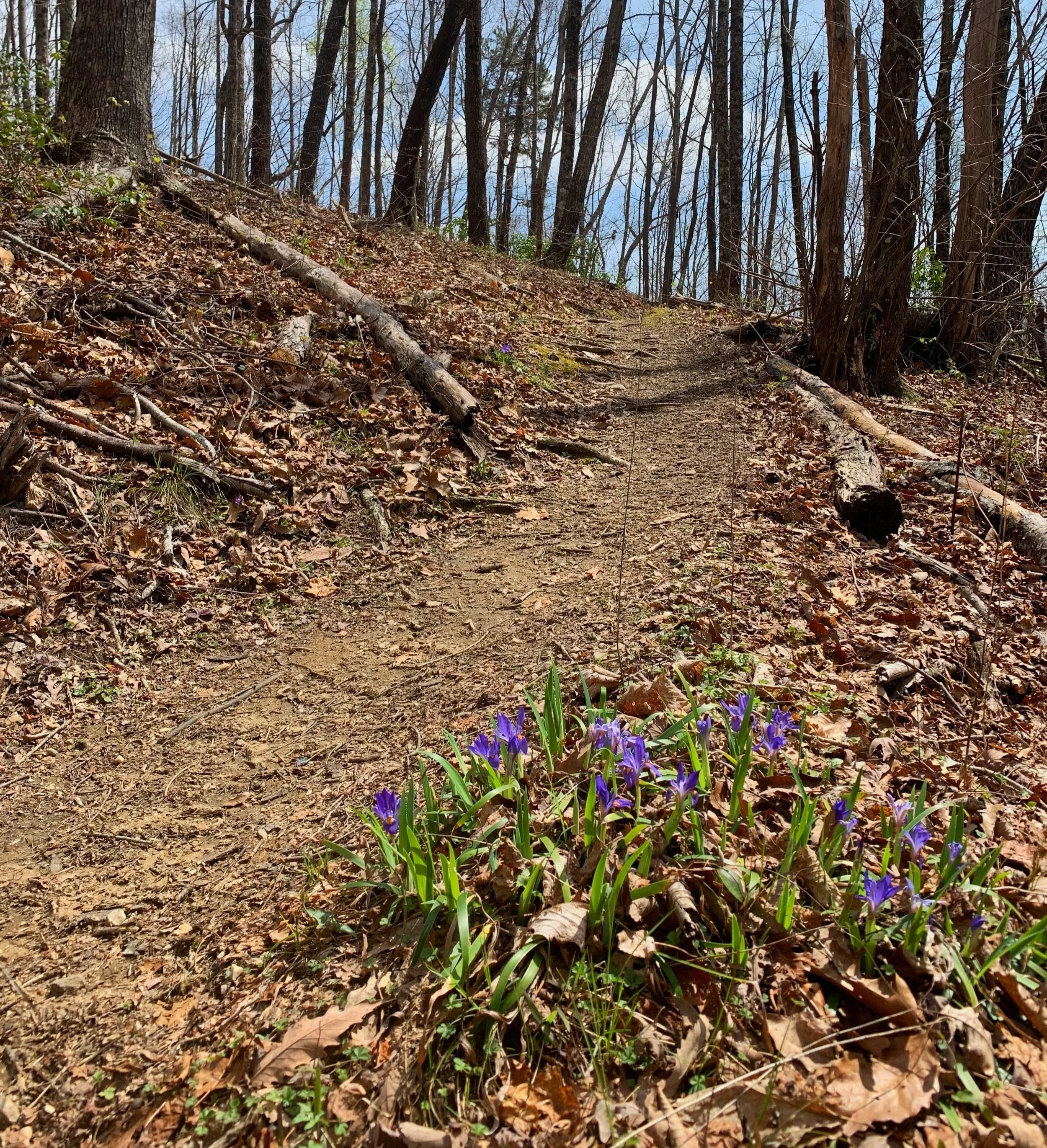
This trail was like nothing I had ever hiked, the entirety of it on the Appalachian Trail so footing and grading was impeccable. Never had I found rhododendron in the wild, my grandparents had them decoratively surrounding their old farmhouse but these pink flowers lit up the trail with such a beautiful aroma, this was a truly magical place to be.
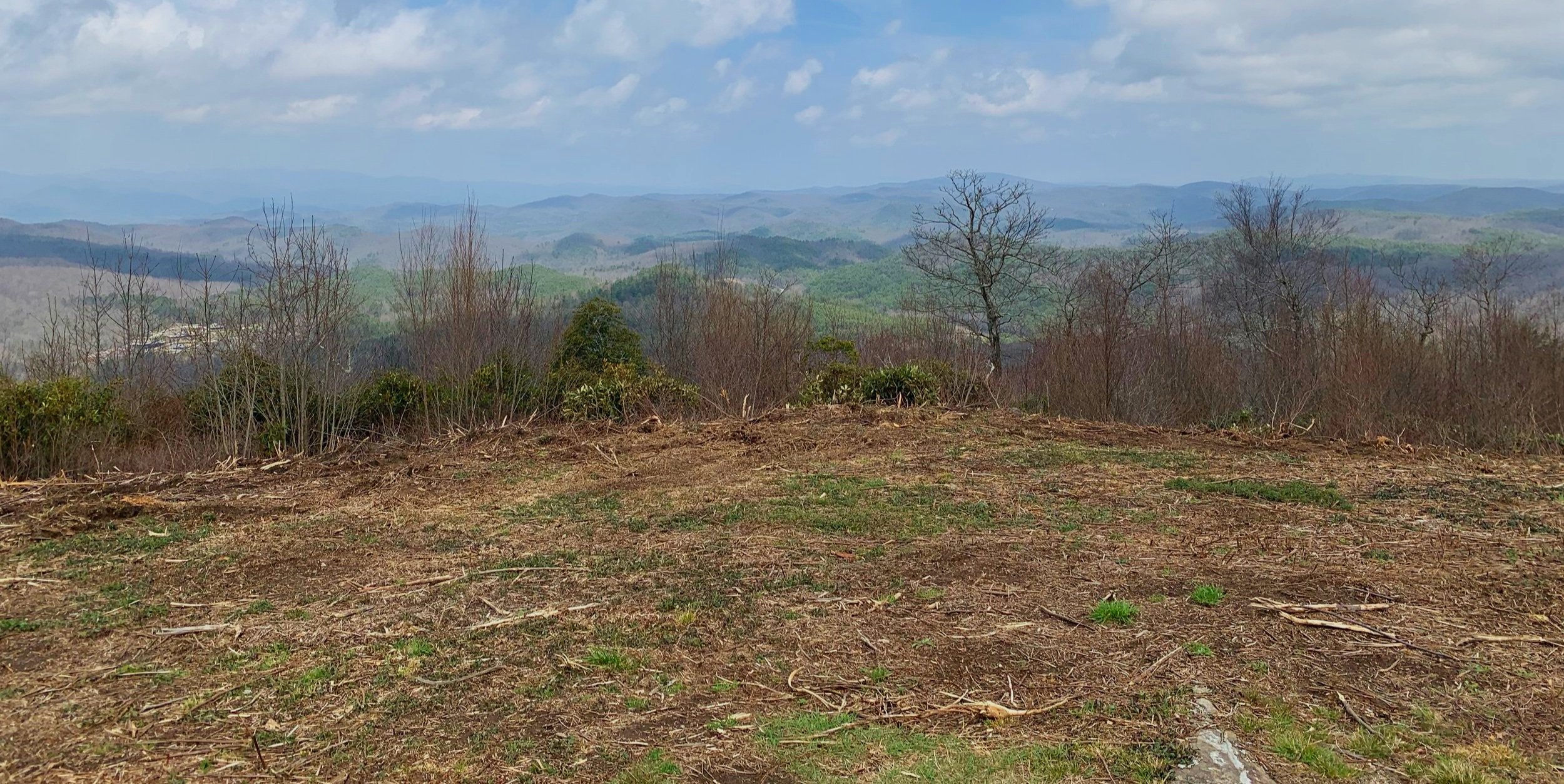
Summit views atop Sassafras Mtn; 3,554’
Not amused at the state of mountaintop, it appeared clear cut simply for the benefit of views and topped with a concrete structure, I suppose it reminded me of the travesty which has become Mt Greylock, Mt Washington, Clingman’s Dome - or any other peak which has become a place for tourists to simply check off; I was better suited to be on the trails, to find myself fully immersed in the sandy footing of a lush Appalachian forest.
With a post-run mid-drive lunch of lentils, raw carrots, an avocado and half a dozen apples, I was still dehydrated from Kings Peak two days prior.

Straddling two states at 3,554’
At this point, a 2-hour drive is hardly a drive at all, especially when you tack in a stop to re-up on Kombucha and produce at Food Matters, unfortunately watermelon (or any melon for that matter) was not yet in season.
Simply driving toward my next destination, I had no plans of where I’d sleep for the night. Arriving in a sleepy Micaville I knew my next stop (tomorrow morning) was the Colbert Ridge Trailhead, conveniently AllTrails was showing several campgrounds in the area - I liked the sound of “hemlocks”, that’s what I based my next big decision on.
Carolina Hemlocks Recreation Area, as soon as I saw the brown and yellow National Forest signage I was all about it. Pulled in to what felt like a ghost town, I know it was a Thursday but did I really have free-range of an entire campground?

Ascending Colbert Ridge; ~5,600’
Knowing how these places work, I drove past the self-pay booth to go track down my perfect site. Site #5 was the lucky winner; a long driveway to deter would-be conversations with other guests, a water spigot at the end of my site and a trail out back to the restrooms and showers, perfect!
By the minute, my intentions to remain quiet and ready gear fell into the nearby South Toe River; the one and only other resident was an old fellow travelling the countryside in a semi-fixed up Sprinter van with his dog. I suppose one would get lonesome for good conversation while out there alone on the road, although I hadn’t reached that point yet.
Minutes after dropping my payment envelope into the self-pay kiosk, two friendly 70-year-olds sped into my site on golf cart ready to accuse me of camping for free or some funny business. I reassured my blue-haired campground hosts that I have a National Park Pass (pointed to it hanging in my windshield), confirmed that I get my discounted camping rate and advised that yes, I did make my payment for the evening and would likely be spending a second night amongst their beautiful old hemlocks.
The excitement wasn’t over until two drunks walked right through my site muttering some nonsense about their campsite not having a fire ring and if I wasn’t going to be using mine they shall like to walk away with it - all this commotion while shaking a beer can in my general direction. Remembering how good it feels to be 4.5-years sober, I simply shook my head, advised that I thought it was buried too far into the ground and pointed in the direction of the campground hosts for them to consult and continued packing my gear for the next mornings alpine start.

Along Deep Gap Trail
6:19am; Colbert Ridge Trail
I had grown accustomed to making coffee the night prior and having it waiting in a HydroFlask mug to begin sipping while still in my backseat bed. The campground had great cell reception and I could shoot Alanna an early morning message and check final weather reports - which made claims of sunny skies by mid-morning.
On path, per my usual anxieties I scanned trailside for eyes and listened for any nearby rustle in the leaves, I was ascending into a hazy white cloud at a decent grade as birds began to awaken from surrounding trees.
Getting closer to gaining the ridge, there were lookouts to glance south and see the coming high places I’d soon be climbing. As the sound of trickling water grew louder, the path became wetter and with this inevitably showed more signs of erosion - I had to pause to remind myself that I was actually in North Carolina - not the Adirondacks where I had grown up - the similarities were stunningly remarkable.
At about 3.6-miles the Black Mountain Crest Trail is followed south (left) just briefly until reaching the Deep Gap Backcountry Campsite, 0.2-miles later. I was in a state of bliss running the Deep Gap Trail, the narrow single-track was exactly what I had been craving. What began as a grassy ridge quickly entered a spruce and fir forest and I was instantly transplanted back on the Long Trail of Vermont.

Along Deep Gap Trail
Along the ridgeline I kept eyes peeled for various survey benchmarks as well as historical tid-bits. The highest rocks of Big Tom and Mount Craig both displayed plaques explaining who they were named for and a brief background. Even with no views there was so much to see and absorb while making the traverse up to the 6,684’ Mt Mitchell.
Exiting fir corridor and entering rustic picnic area the GoreTex layers and heavier gloves made an appearance before trekking the final 150’ to the summit cone and into possible wind exposure.
Traffic was basically down (due to it being Friday? socked in a cloud? or the on-going sidewalk construction at the visitor center?) to zero as I crossed the paved auto road and “hiked” the stone sidewalk enroute to the peak and famous reddish-brown summit sign.
Thankfully I had the ridge and summit all to myself that morning - took a few timed photographs and slowly roamed the tourist trap back to tree line while wishing the bricklayer a great day.

Marker atop Mt Mitchell; 6,684’
I had concluded with myself that all of this today happened for a reason; I needed to be socked in a cloud to truly see and appreciate the pathwork I ran, to see my feet and feel my body moving over the most heavenly single track trail I’ve ever stepped onto.
And just with that realization the dark grey clouds grew lighter and began blowing into whisps as I continued a pattern of trail running and walking my way back through the fir groves. This is one place that I did not want to fast-forward, perhaps I could find the pause button and just lay my head down in this mossy forest for a bit of a stay?

Fir stands of Balsam Cone; ~6,500’
Chilly fingers encouraged movement so I kept trotting, seeking the mid-morning sunshine that lay up ahead. Bouncing down the hand-placed steps I could blink and place my consciousness on Mt Tecumseh, a familiar 4000-footer in the White Mountains back home. The trail runners’ tread creaked as I pushed them to their limits; edging the cracks on the rock slabs and leaning hard into the turns.
Ankles, knees and hips compressed as I absorbed any rocky bumps in my path, splashing through a wet trail that was morning dew only an hour prior. The sweet scent of cedar, spruce and pine lingered in the mist, no candle could touch how alive this forest smelled to me.

Looking back down the ridge
As I descended below the lingering cloud I was blown away by the views that stretched in all directions down into the valleys - this is the view I didn’t know I missed - I couldn’t bring myself to leave this precious land.
Arriving back to the trailhead parking lot I welcomed myself with a Ginger + Turmeric elixer from GT’s (the kombucha company) which featured reishi, chaga and turkey tail mushrooms - and another night at the Carolina Hemlock Rec Area; back to site #5.
With no disruptions on this chillier evening, I posted up in my backseat to rehydrate on 3 oranges; then refueled on: kale, spinach and hemp heart salad; shortly after came desert: pears, apples, raw oats with bananas, cacao nibs, unsalted peanuts, almonds and brazil nuts, lastly: several dates for a sweet touch.
After a much needed yoga session amidst the drifting campfire smoke, I sat calmly, keeping to myself and my mind while I could hear every other camper discuss their lives’ problems at each respective campsite; mine wasn’t so bad any longer… I was living simply -
doing what I love and loving what I do.
Overall stats for the day:
16.70-miles
6hr 29minutes
5,807’ elevation gain
Mount Mitchell - 6,684’
Mount Craig - 6,647’
Big Tom - 6,560’
Balsam Cone - 6,600’
Cattail Peak - 6,600’
Potato Hill - 6,475’

Plaque atop Mt Craig

Plaque atop Big Tom