
West Long Mountain
Following several ascents of local peaks - visits to lower summits of the New Hampshire 500-Highest - finally, the weather appeared to be cooperating with a brief cold snap overnight; I hoped this deep chill would make any snowpack rock solid. Recent conditions had been favorable below 3,000’ - with groomed snowmobile corridors, and a supportive snowpack following the most recent dumping of snow, now, nearly two weeks ago.

Foot traffic is welcome along Summer Club Road
Knowing that the access road and trailhead should be plowed this far out from any significant precipitation, I checked multiple weather agencies for an overall picture of my weather window, perused both newer and older topographic maps for old logging roads which might aid in off-trail travel - even satellite imagery can be highly informative in this department, when planning to hike off trail. With curiosity piquing my interests, I set my GPS for way north - to the trailless, Long Mountain.
Arriving in Stark, NH, I was surprised at the lack of snow on the ground; perhaps 4-6” blanketed overwise grassy lawns as I sat momentarily at a flashing railroad crossing with a missing locomotive - ice issues in the block signaling system, perhaps, or maybe they were simply shuffling cars in the block, just out of view. Continuing to trace the railroad grade along Percy Road, it was tough fitting a school bus beside my Subaru through the narrow county road, the aid of a driveway made the passing elementary.

Entering SPNHF conservation land
Eventually, signs for the Kauffman Forest are encountered roadside, welcoming guests to recreate responsibly around the SPNHF (Society for the Protection of New Hampshire Forests) conservation easement. Utilizing old logging and woods roads primarily, a vast network of trails guide visitors to ponds, peaks, and various other paths around the wilderness. Parking for footpath (as well as Christine Lake) access is found atop a rather steep Christine Lake Road; gaining several hundred feet in 0.4-miles, the road passes over a stunning cascade of Rowells Brook at about halfway up the hillside.

Off the groomed snowmobile corridor - time to snowshoe!
At the top of Christine Lake Road, all traffic must veer left into the visitor parking area; straight ahead, Summer Club Road proceeds beyond a green gate, leading toward hiking trails, as well as the summer camp homes at the western end of the lake. With snowshoes strapped to a 75-liter pack, I was weighted down with all the typical winter bushwhacking gear - plus standard emergency gear, with alpine bivy and several sets of dry clothes. Beyond the gate, the roadbed was a sheet of ice, any traction was afforded by old, frozen, snowmobile tracks.
Reaching a point about 0.4-miles into the trek, the main, groomed snomo corridor veers westward, while my intended route along the Lamphere Trail was completely unbroken - only a pack of coyotes had roamed this stretch of old roadway recently, their tracks barely breaking the surface of the snowpack. With snowshoes now on mountaineering boots, I thought I had hit the bushwhacking jackpot when the first steps onto unbroken snow hardly sunk an inch - I was standing atop a 15-18” snowpack at about 1,300’.

With solid snow, bushwhacking in winter doesn’t get much better
As a sense of relief overtook my mind, putting fresh tracks in the snow was as efficient as one could ask for. All attention was taken off not stepping on my own snowshoes, to gaze around the surrounding hillside: ascending through a recently logged hardwood patch, the view southward, toward the Pilot Range was marvelous: the ridges, bumps and rises all snow-caked, glistening a brilliant shade of blue and white.
Swinging north-northeasterly, the Lamphere Trail begins to trace alongside Rowells Brook; passing an old chimney (which I never spotted in regular summer foliage), and then a winterized summer cottage, the trail grows narrow as it steadily climbs to the next junction at 1,850’. Along the ascent, snow-loaded balsam fir could be seen upslope, draped, and hanging over the treadway - thank goodness for Gore-Tex layers. The snow remained supportive during the trek up to the Bald Mountain Notch Trail-Rowells Link junction (Cohos Trail).

Reaching the clearing: a moose was bedding on the right path - I went left
The weather forecasts, which I recalled seeing the night prior, were calling for overnight temperatures approaching single digits. This morning, I found myself hiking in temperatures which hovered just beneath the freezing point, which were far too hot to efficiently trek in Gore-Tex layers; needless to say, I found myself shedding clothing until only base layers remained.
During the first attempt of bushwhacking the Long Mountain peaks several months ago, I continued following the yellow-blazed Cohos Trail as it snaked westward, navigating around many soggy patches enroute to wider snowmobile corridors. Recalling the forest in this stretch to be friendly and favorable, I opted to cut the distance right out, and simply beeline across Rowells Brook (which was thankfully snow-bridged), and strike a course north/northwest, through the forest.

Avoiding blowdown, I stuck to open woods as much as possible
Once across the brook, I found decent woods despite loads of limbs and various other forest debris emerging from the snowpack, beneath the dense, evergreen canopy, the snowpack had softened slightly - I found no crust layer, only 8-12” of fluffy powder. This dense (not thick, just dense canopy overhead) patch of woods lasted perhaps 0.2-mile before opening up to a fondant-like snowy blanket, stretching as far as could be viewed into the hillside. The mixed woods were beautifully open and rather efficient to navigate through here.
At a point that I suspect was halfway between the Cohos Trail and what I assumed to be snowmobile trails (assuming, based on their prominence on most topographic maps), I encountered the first set of moose tracks. Laughing to myself, I could peer all the way down the hooved posthole, nearly two feet down, until hitting the leaf layer below. Taking a look at the tracks, my best guess was that they had been placed just that morning, as they showed no freeze/thaw cycles - very crisp tracks indeed.
While beautiful, here is a sea of spruce traps
Crossing the deep, moose tracks, the going remained relatively easy along the route toward the wider, old roads. I was assuming these corridors would be packed by sleds as I had trekked those exact routes in autumn; with lofty views found higher along these old roads, I assumed this to be a proper destination for sledders. However, upon reaching the old woods road, I found that I had not only encountered a trail much more enveloped, and grown-in with bushy balsam, the only tracks along this stretch were from moose - this appeared to be a regular moose highway, with fine bedding establishments dotting trailside.
With an old bear bell jingling wildly on my pack strap, I began talking loudly to myself, as well as any nearby moose. Reaching a cleared, three-way intersection, about a dozen old, hair-filled moose beds could be seen around the perimeter - as I looked up from my snowshoes to peer down the brushy corridor which I had intended to follow to the base of West Long Mountain, I saw a medium-sized (~1,000-lb or so) moose jolt with alertness. Standing up, she gazed back at me, both of us frozen momentarily.

When not dealing with spruce traps/blowdown, the forest was pleasant
As mama moose turned to trot further up the old trail, I stood in the clearing briefly to rehash a plan, as my intended route was now blocked by a moose which I refused to pester any longer. Following older moose tracks into the secondary, westbound road, the snow surface was anything but a joy to trek. Unless venturing into the dense, spindly regrowth surrounding the trail, there was not an un-churned, refrozen piece of snow to be found.
Once the surrounding forest appeared to relinquish its tight grip, I diverged from the choppy surface when I could see more unbroken, pristine snow. Down low, progress was rather efficient thanks to a forest of mature spruce trunks; the canopy struggled to let daylight in, but to find oneself back on relatively supportive snow was a dream come true. Unfortunately, these favorable conditions were quickly coming to an end, just ahead.

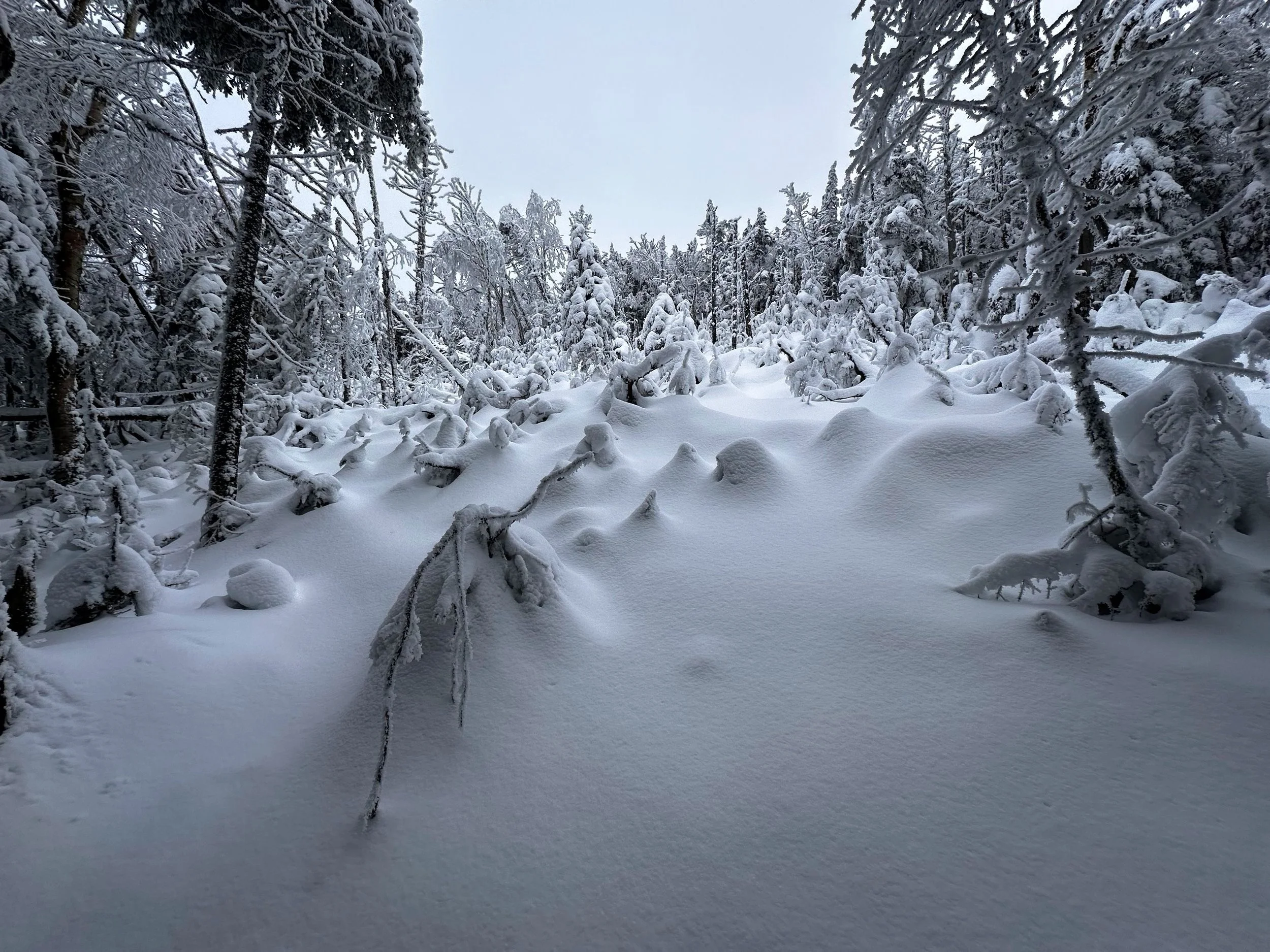
Nearing the high point, trees were encrusted in blown snow
As the slope before me began to pitch, I was reminded that I forewent a more gradual ascent, upon encountering the moose, for a climb directly up the steep southern aspect of the mountain. Any semblance of supportive snowpack was whisked right away while ascending West Long Mountain proper: I found, anywhere from 12-18” of loose, unconsolidated powder residing directly atop the older (month or so at this point), icy crust. This combination, in my mind, is the dictionary definition of abysmal conditions. The breaking was arduous, progress near mythical as one snowshoe step forward almost always immediately cascaded equidistant, back downslope.
Eventually, I switched from a direct line of approach, to an easier track of creating my own switchbacks to cut the pitch somewhat. This technique worked wonderfully until encountering the first patch of massive blowdown; here, I also found the first chest-deep spruce traps for this winter season. On several instances along the ascent, I stood at a wide patch, devoid of nearly all standing trees. While the snowpack was smooth and inviting, I knew what topped mess that stunning, snowy blanket was hiding. Retracing my steps, I was constantly working a path around the toppled devastation for the second half of the steep climb.

Quite a wintery scene at 3,661’
Only several times did I need to pull up my hood before shouldering through scrappy conifers - those branches were terribly woven, and frozen in place. Eventually, as the hillside began to taper, as did my excitement - the fact that my legs were screaming from snowshoe bushwhacking in deep powder, the day following a long, road run slipped from my consciousness. Reaching the airy summit of West Long, I had decided earlier in the strenuous climb, that a visit to the main peak was obviously out of the question today - this snowpack was downright opposite of any snow I’d want to trek further, whether to navigate around Long Mountain Pond, or any of its surrounding bogginess.

Southern views just visible beneath the cloud ceiling (through trees)
Around the broad summit, I searched - even using my glove to knock the thick, once wet snow which had been blown sideways, every tree around the 3,661’ summit had been completely caked in inches of wet, blowing snow. For about 10-minutes, I ventured from possible high point to the next, encircling trees which I could dub the highest. After satisfied that I could not roam the mountaintop any further, and with outer layers beginning to freeze into absolute rigidity, I concluded that, today was not the day to locate the tiny PVC canister - in all actuality, I likely walked right past the register, but with the trees coated as thickly as I had found, there was no way I could have found a small, white tube in a sea of white, stubby branches.
With warm tea as fuel, I coasted back downslope just as expected; each step becoming a downslope glissade of 6-feet or more with each step - that was my kind of forward progress! Using mature, solid spruce trunks to slow my coasting, today’s bushwhack was a full body work out. In what seemed like minutes, I descended what took an hour and twenty-two minutes to scale; over 1,000’ of elevation loss/gain in 0.6-miles to get the heart pumping.

Best part of winter bushwhacking: following tracks back out
Following my ascending tracks back out, I offered words of kindness in an obnoxiously loud tone, if in case the moose from earlier in the morning had wanted to hang around their bedding area. When in actuality, I should have taken to the woods to avoid their obvious bedding area on the return, at the time, however, I just wanted to skirt through their territory unnoticed.
Before long, I departed the churned snowpack of the moose highway, beginning the wooded approach toward the Cohos Trail. Briefly, I thought of a side trip to another NH 500-Highest; 2,320’, Bald Mountain could be viewed through the open canopy. While the low peak was awfully enticing, I could not bear another uphill step, just to cascade back downslope; that little peak would be a trek for another day as well.

Exiting the narrow corridor as the sun breaks through
Blue skies began to appear overhead as I neared the Cohos Trail junction. “Perfect timing”, I thought, as the surface layer of snow began to soften in the morning sun; I arrived back to my car before conditions became any more treacherous. While standing lakeside, at Christine Lake, the bald, snow-crusted Percy peaks rose up across the lake, as stunning as I had ever witnessed the pair of peaks. To the north, I could observe the shoulder of Bald Mountain, rising just behind that darkened mass was a sliver of brilliant white - the West Peak of Long Mountain. Thanking it once again for allowing me to pay a visit, I ruminated over the morning I had just created, and the winter conditions I had just experienced. Seems to me I have many NH500-Highest peaks in my future, where I will seek out better snow conditions - March is always better above 3,000’, anyhow.
Overall stats for the day:
7.65-miles
4hr 30 minutes
3,980’ elevation gain (as tracked with COROS Vertix2 watch; ~2,500’ climbing is more realistic - it is higher from constantly sliding backwards/downslope while ascending, likely due to copious spruce traps as well)
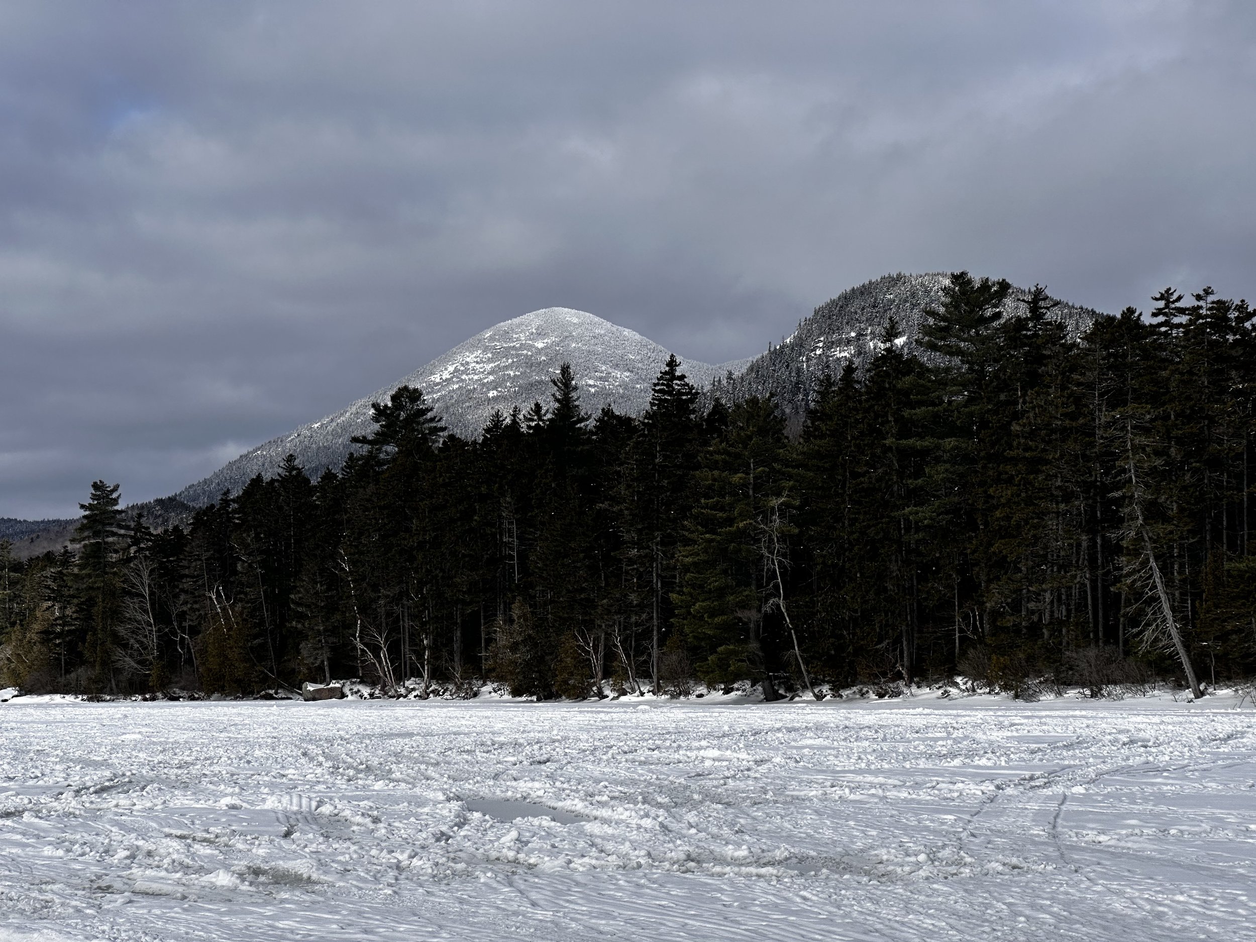
The Percy Peaks from Christine Lake