
Sassafras Mtn (S. Carolina HP)
From a single day ascent of Utah’s state highest two days prior, I had been driving eastbound since - with foul weather whipping in my rearview. To take advantage of a narrow weather window, I stopped driving for a trek to South Carolina’s high point, 3,554’ Sassafras Mountain, while the sun was shining, making ground temperatures feel like spring.
Cruising along the Blue Ridge Mountains of the Appalachian Range, I meandered a very windy US 178 (Moorefield Memorial Highway), switch-backing tightly downslope until meeting Laurel Valley Road, where signs roadside indicate horse traffic just ahead. Finding a small spot to park my Subaru as to not block traffic in either direction, I studied the trail map one final time, locked the car, and began trekking toward Sassafras Mountain.

Ascending out of Chimneytop Gap
The trail I would be ascending was a section of the well-graded, 77-mile Foothills Trail; the white blazes briefly had me thinking I had somehow staggered onto the Appalachian Trail, but that longer distance trail can be found further to the west. Before crossing US 178 I glanced down a rugged embankment which led steeply to Eastatoe Creek. On the far side of the road crossing a small trail sign welcomes foot traffic to the Foothills Trail.
Rising out of Eastatoe Gap, lush, viridescent laurel leaves droop from overhead boughs; for this springtime hike, the surrounding forest remained airy and open despite a rather dense understory. The trail is overall stunning: an immaculate treadway provides a pleasant stroll for hikers of all ages and ability levels to hike. Early along this leg of the Foothills Trail, softly rolling hills stretch far into the distance; lighter patches of forest afford restricted views along the trek - suggesting hints of mountainous contours through the leafless hardwood canopy, sometimes even picking out neighboring hills and ridges.

Years of fallen leaves comprise the forest floor duff, casting a warm glow as the various hues radiate warmth given by the sun. In small clusters, purple irises poked up from trailside fallen foliage, their low leaves early in the season resembled tufts of unmanicured lawn as I passed. As the Foothills Trail sidehills the southwestern aspect of Chimneytop (2,800’), views abound as road noise can occasionally be heard while approaching. Continuing to sidehill the mountain in a northeasterly direction, eventually the trail pitches downward gently to meet the F Van Clayton Memorial Highway.
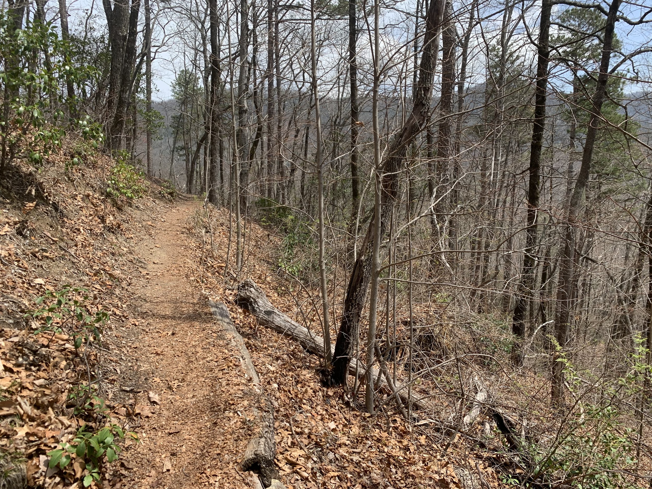
Restricted views accompany much of the Foothills Trail in spring
Parking for Chimneytop Gap access can be found several rods to the north; taking a moment to read various postings on the hiker information kiosk, I traced my route along the larger map, glanced across the roadway to find the next section of my Foothills Trail hike. Welcomed by more open hardwood forest, this side of the highway featured considerably more ferns and trailside mossy patches. The most incredible aspect of this hike was strolling beside bent trunks of old rhododendron, the lush, evergreen canopy remained humid despite the dry, blue-sky day.
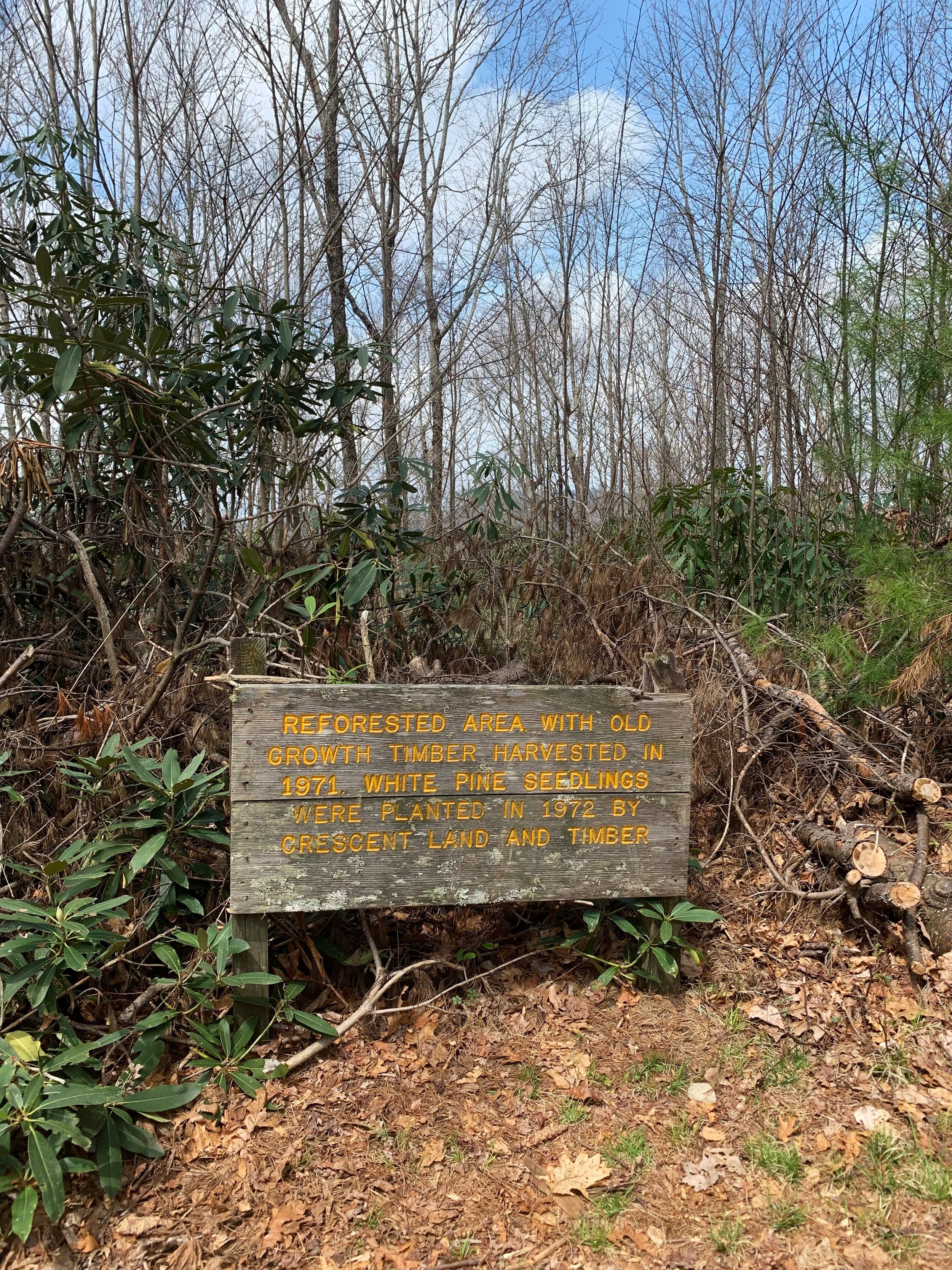
Reforested area nearing the high point
As the Foothills Trail meanders closer to the state high point, it swings into the footprint of an old road corridor as hikers are led over a narrow ridgecrest. More trailside signs inform hikers of the historical significance of the surrounding woods - having been reforested more than fifty years ago! The sign states white pine had been planted, but no amount of searching turned up any significant patch of pine, I am still curious about this finding years later. The wide path cuts through brilliant tufts of bushy laurel while trekking toward the summit.

An indiscernible ridge walk
Crossing the Memorial Highway yet again, I re-entered the low woods for the final ascent to the high point. Perhaps it was just the seasonality of my visit - the summit area, however, appeared as if it had just received a clear-cut haircut. Traipsing from the hiker path to wheelchair accessible walkway, I could shut my eyes and place myself back on the trailless mountainside of Elephant Mountain (backwoods of Maine) - where I had encountered perhaps the most atrocious logging slash of all time, what I found atop Sassafras Mountain was a strong contestant for runner up.
Perhaps the Headwaters State Forest were simply opening up the summit panorama, in preparation for warm-weather hiking and tourist season. A light breeze blew across the 3,554’ mountaintop; while roaming the high point, a group of tourists showed up - thanks to the wind in my ears, it was as if I still had the summit all to myself; without stale car exhaust or gaudy perfume blowing across the Blue Ridge Mountains.
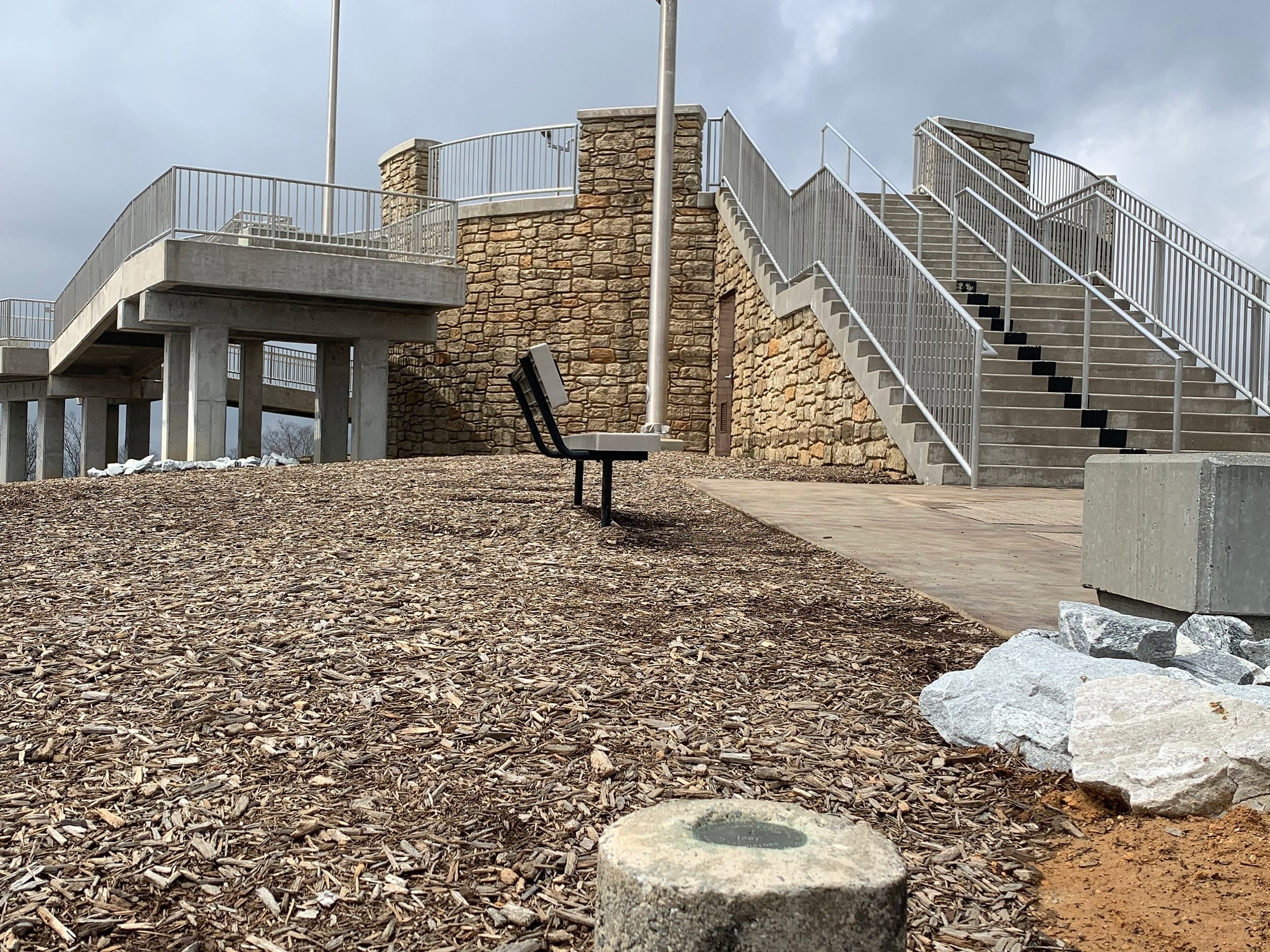
Summit observation tower
Reportedly, before this newer summit observatory tower was completed in 2019, an original structure stood on this site until 1993, at which point it was removed. Later, in 2012, students from Clemson University installed a small observation platform; I did not look around for the older decking on this excursion. The views from the summit are magnificent, expansive vistas in all directions welcome those to make the trek to the high point of South Carolina.
While the tower is gorgeous, and it is great to see mountaintops become accessible for those who otherwise cannot scale peaks under their own power. For a lover of the wilderness, summits like these are more about the forested trek spent to reach lofty places - not the desecrated high place which has had its summit vegetation ripped out of the soil simply to catch a view of subsequent hills and ridges.

Views from the cleared summit area
If I were to embark on an end-to-end thru-hike of the 77-mile Foothills Trail, I do not believe the summit of Sassafras Mountain would be the high point of the adventure. Sure, lofty views abound from the cleared summit, but the ease of accessibility (ie: drivable to the summit), manicured walkways and summit vegetation - it was all too landscaped and handed to visitors on a sanitized platter for my taste. I’ll take a nice wooded, ledgy view any day.
Strolling around the high point of Sassafras Mountain, benches and concrete resting places are available for guests; a survey benchmark disc can be found in plain sight, embedded in a concrete post atop the mountain. One of the most interesting features of Sassafras Mountain (aside from astonishing views), is the state line, which is denoted in the observation platform, a massive compass can also be found atop the mountain, to help orient guests.

Massive compass atop Sassafras Mountain
The descent of Sassafras Mountain was much more enjoyable than my stay at the summit, trail running downslope along the soft, earthen footpath was a joy. While the panorama was no doubt stunning, the amount of concrete, steel, and plastic infrastructure which now resides atop this, as well as so many other state high points - as an instructor of Leave No Trace principals, the sight of such a summit makes me think we could do better at protecting these wild places, while still enjoying its natural beauty.
It just seems that the purpose of an observation platform was to place visitors above the mountaintop canopy, yet the surrounding vegetation had still been hacked down despite the presence of the concrete observation tower. It is by hiking to places such as these that remind me to appreciate the other remote tracts of trailless wilderness, where moose and bear occupy more of the population than bipedals.
Overall stats for the day:
8.63-miles
2hr 22 minutes
2,080’ elevation gain
Sassafras Mountain - 3,554’

Survey benchmark disc atop the state high point