
Two days climbing in the Dry Brook Ravine
Day One.Dry Brook Slide
In the never-ending quest to ascend new routes in my local White Mountains, recent research had piqued my interest regarding a rockslide located on the southwestern side of Mount Lincoln, in the Franconia Notch area. Armed with blog posts and several multi-season climbing reports I drooled over alpine photographs to surmise whether this route was in my scope of capability – heck, even the Eastern Mountain Club website had a blog (read it here) about the climb being similar to an “Adirondack slide climb”, my old, childhood stompin’ grounds!
Located in the Dry Brook Ravine between Mounts Lincoln and Little Haystack, this slide, I have found, goes by several names. You’ll most likely hear it referred to as “Guy’s Slide”, referring to the late Guy Waterman who was a well-known local bushwhacker and wilderness advocate. There are accounts of this slide called quite simply the “Dry Brook Slide”, as well as a winter climb along the same route known as “High and Dry”, listing moves in the 5.4-range and for “experienced climbers only”.

“Guys Slide”, Dry Brook Ravine
It is suggested that in summertime this route be ascended only in good, dry weather. I had henceforth not had weather conditions that intrigued me to make the climb, but a winter ascent... I mean, why not?
I cannot seem to turn a visit to The Mountain Wanderer bookstore in Lincoln a quick in-and-out adventure. With countless rabbit holes to send our conversations, one is sure to learn something new from the book shops proprietor, fellow bushwhacker and avid slide seeker, Steve Smith. During the visit to his shop we must have discussed a dozen or more slides, bushwhacks and new treks we had each taken in the nearby hills. Upon returning home I became immersed in his well-written blog posts (check it out here) complete with more photographs than a Flickr account.
In the days leading up to my climb, I watched various weather reports like a hawk and searched online forums for up-to-date photos of the ravine; snow had not fallen in days which meant any leading to or remaining on the slide itself would likely be consolidated and take spiked traction nicely. Also, worth noting, this is a southwesterly facing slide which I was hopeful that the lack of snow had not completely melted and ran into the Dry Brook drainage.
Armed with both a technical ice axe and a more aggressive ice tool on my pack, Hillsound spikes for the approach and full crampons for the ascent, I was certain we did not have the snowpack necessitating snowshoes at this point in the season.
8:21AM. Backed the Subaru into what I have dubbed “my spot” at the Lafayette/Old Bridal Path trailhead parking lot and laced up the mountaineering boots. Vacating the warm cocoon which was my Subaru became the hardest task of the morning, but eventually there was nothing holding me back, so the door creaked open, boots hit the ground and with a beep of my COROS GPS watch I was being followed by multiple satellites high above.
While doing research and “prep-work” for this climb I was able to construct a rough track in which I would contour the initial Falling Waters Trail and begin the one-mile bushwhack to the base of the slide climb. I then uploaded this GPS track to the Vertix2 watch, allowing a continuous view on my wrist via topographic map with my created track overlaid in one color and my active track overlaid in yet another. Clever little instrument, if I may say!
Falling Waters was typical up to my breakaway point; an inch or two of powder adorned the trail which was a convenient bed of grippy ice below – smooth sailing as I photographed the many waterfalls along the way with Cloudland Falls being the 80-foot crescendo before I said my good-byes to blazed path.
At the final brook crossing as trail begins its zig-zag of ascending switchbacks climbing the 4760ft Little Haystack, I continued straight in a northeasterly direction, following Dry Brook as it guided me toward my objective and before long Mt Lincoln and the towering pinnacles, or more aptly known, “Gargoyles” came into view.
Generally following a simple path along the right side of the brook, I weaved between decimated blowdown entwined with conifer and birch saplings. Gentle rolling ups and downs dotted with occasional awkward side slopes kept my attention present and for balance the Black Diamond technical axe became clutched with one hand acting as a cane while the other continuously swept aside snow-covered branches.
Before long the decision was made to ditch the woods in favor of the brook itself; the water was low enough and to my surprise, within several paces it had completely disappeared underneath the entanglement of strewn boulders which lined the base of the 10-foot-deep trench.
Tedious steps on these jagged boulders brought a deep sensation of looming claustrophobia, I hustled to the north side of the landslide track and found myself standing atop a mound of violently tossed dirt, rock and tree remains. This was the toe of the more recent 2017 slide at the exact point the mass tumbled downslope and wiped out the existing the brook and slammed into a 90-degree turn, providing an open view clear up to the headwall of the 600ft slope.
One more section of bushwhack stood before me and my main objective for the day. Generally remaining in and using the narrow wedge-shaped track of flowing water, thankfully most of it being under ice or rock which made for a quick traverse.
Reaching the base of my climb around 10:30am, I swapped the baby spikes for Black Diamond 12-point crampons which fit much better on the bigger, stiffer, more insulated mountaineering boots. The day called for wind, so the Gore-Tex shell got added to the wool/fleece blend mid-layer, gloves were switched for a fresh set and now had both ice tools in hand. The climb was on!
Ascending Dry Brook Slide, ~4300’
This southwestern facing slide had about an hour worth of morning sunshine and as a result I could hear trickles of meltwater underfoot as the rock and ice warmed in the rays.
I recall thinking most of the climb that I would not have wanted to be on that ice any later in the day, several spots were getting soft but most of it taking the axe throws very nicely, which was to my advantage for climbing but I didn’t place much trust that a chunk wouldn’t collapse, shift, or shear off the algae-covered rock beneath.
Carefully, I picked and weaved my ascent trying to focus on my path ahead and not worrying how high I had come – only how far I had left to climb and spotting a doable route ahead at all times.
At several points along the ascent, ledge tops were gained where I could stand briefly to rest the calf muscles, relax the forearms, and even snap a few photos of my beautiful surroundings.
Without much snow on the route itself, the occasional clear blue ice really highlighted what I had been climbing on and nearing the ridgeline had switched from bulging ice-covered rock faces to more loose snow-covered talus and scree that seemingly wanted to roll out from under the crampon spikes.
At this point I was merely a speck of a body between the gigantic rock spires which stood guarding the Franconia Ridge trail from the ravine headwall. Snow on the upper chute was littered with crumbling rock dust, evidence that while the White Mountains appear rock solid, they are constantly being weathered, shattered, and broken apart piece by piece.
According to my watch maps, it appeared as if I was nearly standing atop the ridge trail! Looking like ants, I could spot other hikers dotting the summit of Little Haystack. I wondered to myself if any of them grew curious at the constant chipping of metal points into rock and ice below them.
What stood in my way at this point was the crux - the sketchiest move yet, sure a fall on ice up to that point would have sent me for a ride until arresting with a swing of an axe but this sucker was steep, slick and full of consequence! With a mind entirely focused on comprehending options I gazed right: climb a 15’ spire? Probably not; gazed left: climb a sloping rock with no handholds and steep, sloping foot placement? No thank you. I chose the route directly ahead. With one ice tool I fished for a rock-solid placement, the only option that I could discover was to wedge the pick between two rocks, twist slightly, and sandwich it into place, perfect. With a blind jump off the solid rock below I was able to land the second axe pick into snow-covered rock edge further up the ridge wall.

Topping out, ~4900’
Before I could settle into the belief that I was able to complete those maneuvers, I stood atop the Franconia Ridge trail with completely beat legs and looked back at my route and whispered, “I fucking did that.”
Not a soul was around to see me top out and I was thankful for that. It was my moment of accomplishment.
With legs still running on adrenaline I shut my eyes briefly once atop the 5240ft summit of Lafayette and let the wind engulf my being - giving thanks for being allowed a safe ascent on this day.
Day Two.2017 Slide
After a weekend of rest and no doubt hours researching the 2017 slide that had just become burned into my retinas, I planned another adventure for that Monday. Initial ideas were scrapped due to lack of snow from rain early in the weekend and several days of warming sun to follow.
8:19AM. Backed once again into my familiar parking spot at the Lafayette/Old Bridal Path trailhead, boots were laced back up, watch set to track like big brother, and I took off down the Falling Waters Trail. Due to traffic, rain, sun, thaw, freeze, thaw, refreeze, the trail was now solid ice with tops of granite poking through, ready to dull my spikes and make me sad at the sound of metal grinding on rock.
It was quick going though as I got my breathing into a steam locomotive-like routine and supercharged the muscles with good ol’ forest borne oxygen, ready to (hopefully) haul this body back up another steep pitch!
This morning the waterfalls were clearly visually and audibly flowing much harder than several days prior, to my delight the water crossings were icy but completely manageable.
It felt very peculiar and almost comical to exit the blazed trail and begin following the very tracks that I had just laid in the snow several days prior, easily marking my path through the bushwhack section and even utilizing my old steps as the snow had grown quite solid over the weekend.

Looking up the 2017 slide, from Dry Brook Ravine at 3440’
With the image of the ominously destructive 2017 slide fresh in my mind I now viewed the gully approach through the debris completely different, the thought of a repeat slide tearing through this trench a very real possibility in my mind. With one foot in front of the other I talked myself out of utter oblivion and within what seemed like half the duration I was back standing once again at the base of the massive scar.
This slide is reported to have fallen during a heavy rainstorm on Halloween, 2017, also triggering several other slides in the area, it clearly appeared much newer than many others found in the White Mountains, dirt nearly smelled fresh, I found the area devoid of much regrowth on the slide itself.
Again, at the base I switched into full crampons, Gore-Tex shell, new gloves and donned my two ice tool buddies. I was protected by trees and yet I could feel the icy wind gusts tugging all the way down around 3,400’ where I stood.
Given the initial gentle grade I began by utilizing my longer ice axe as a cane and it quickly became evident that this slide was still an active one. Basketball sized rocks had careened down the base of the slide even since this snow fell in the past several weeks, balls of snow had rolled and left their own paths - demonstrating extreme instability in the sandy hillside. The snow was again littered with rock dust, and I did not want to stick around in that slides mouth any longer than it took to scurry through safely, photos could be taken from higher ground!
While trying to stick to the white ice that took an ice tool pick much better than the blue and green translucent gloopy ice flow, there was nothing I could do to avoid it in many places along the climb. Axes and feet both got kicked and thrown harder on this slide – there was much more ice to contend with on this side of the ravine.
I found it incredibly rewarding, picking and weaving my way up the ice flows, meandering up a route that was not out of my ability level, testing my confidence in climbing while not blindly placing my life into “hope this holds!”.
Mind-blowing views of the cliffs adorning the eastern shoulder of Mt Cannon began coming into view behind the Old Bridle Path. Early sunshine enhanced the lines and cracks in its weathered face. Even my slide from several days prior stood behind me like a gigantic zipper going from the ravine floor to nearly the 5089ft summit of Mt Lincoln.
Although I could again hear a trickle of water deep below, this newer slide faced north/northwest and was sheltered from the warming sun all day long during these winter months, the ice much more solid than that of the recent climb across the gully.

An icy slide climb, ~3800’
All the while as I chipped and kicked my way up this steep face, I looked with disbelief that what I saw actually was the absolute top of the slide, that is until I grew closer and closer, higher and higher into the sky until I could touch the tangled roots and rocks which had yet to join their fallen brothers and sisters far down the bumpy slope of bedrock.
I had topped out on the 2017 slide and what a climb it was! At times the amount of ice spanning from side to side across the ledgy face and into the woods was enormous but with great care and particular picking and meandering of a route up, this scar it was entirely possible. Now, all that was standing between me and civilization was a thick balsam fir bushwhack to get back onto the main trail.
Turns out in my anticipation and excitement to continue climbing, I was ascending parallel to the Falling Waters Trail! A quick change of course to follow the contour, before long I was grinning ear to ear at the fact that I now had crampon points back on a blazed trail. Another huge success!
As it was still early in the day and this ol’ bucket of bones was feeling up to it, I huffed my way up the icy path which leads hikers up to 4,760’ Little Haystack in search of more views and a good time. From atop the minor peak I could stand proudly and gaze at my icy route from the other day; today’s slide was just out of sight in the ravine.
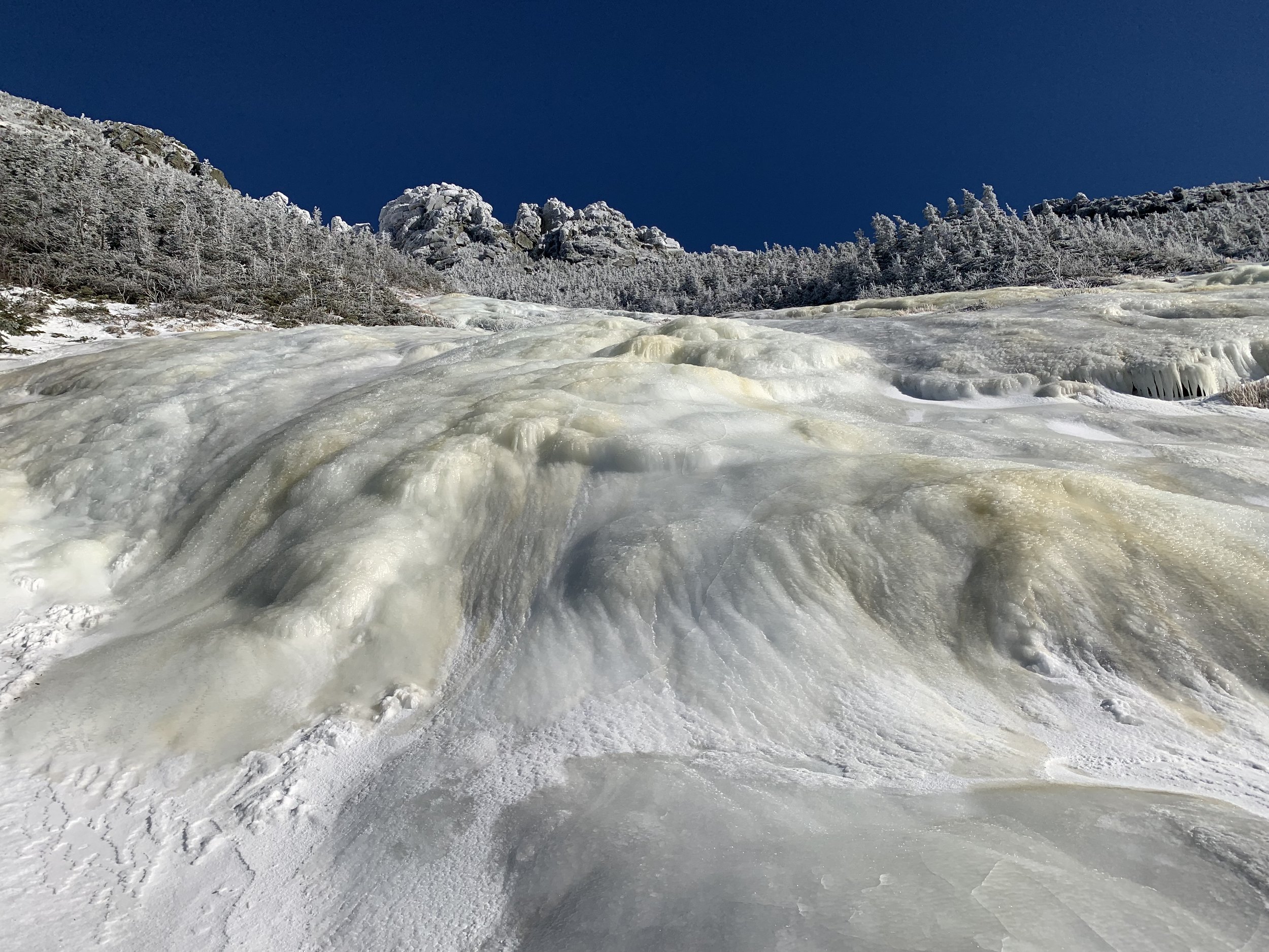
An easy descent was made with the big spikes of 12-point crampons for the 0.3-miles to the AMC alpine zone awareness signage and spur trail out to Shining Rock, a place I spied on from the Old Bridal Path just days prior, a large (more horizontal, 800’ long x 200’ tall) land slide that has beautiful views westerly.
At the open rock it seemed as if the entire massive face was glazed in inches of glistening white and blue icing, dripping from top to bottom and from one side to far as the eye could see. I tried to think of a moment when I saw more hulking ice so close, I couldn’t. Such a glorious sight that I promised a return visit to at another time to soak in both the sun and the views.
My two days of Dry Brook Ravine adventures was nearing an end, so I entered a meditative state of bliss and tramped back down to my awaiting Subaru, all the while wishing I was still back up chipping away and kicking steps into that glorious ice adorning the Dry Brook Slides with the highest peaks of Franconia standing guard just over my shoulder.