
Mt Liberty, Southwest Slide
An inch of fresh, dry, powdery snow had fallen overnight coating the roads and dulling the sounds of people making their commute to their day jobs. After reading reports of icy trails in the White Mountains following yet another day of rain and several more of sunny weather over the weekend, I had another slide in mind. Fearing the steeper, higher slides of western Franconia Ridge nearing Lafayette may be reaching an unstable status, I opted for a more low-angle slide that had popped up over and over again in my recent reading and research.
This morning brought me to the Basin parking lot right off I-93 in Franconia Notch with the steep face of Cannon looming just over my shoulder as I geared up and laced the mountaineering boots. For this trek I was interested in visiting the 1883 slide which careened down the southwestern shoulder of Mt Liberty; the rainstorm which brought this long cascade of rock, mud and forest down to meet up with Flume Brook; the same torrent which also created the iconic slides on the western face of Mt Flume just down the ridge.

Old logging road to make the approach easier
Armed with layers, several pairs of gloves, multiple beanies and neck gaiter, Hillsound spikes and my Black Diamond crampons, a technical ice axe as well as a Grivel ice tool rounded out my arsenal for the day. Old trusty Coros Vertix2 was set to record my every step along the way and finally at 7:37am I stepped out into the frosty woodland world and hoofed it down a snowy Franconia Notch Bike Path.
To my surprise I was not the first set of boot prints out on the trails this morning, following a small set of bare boot tracks, and judging by wind, I tried to tell (there was minimal so far this morning) how fresh the prints were. I followed my friend onto the “bushwhack”/cutoff which leads up to the Liberty Spring trail.

Getting rocky in the drainage, approaching the slide
It was easy going for the first several miles, which I covered in under an hour following the boot prints over rocks, through mud that had yet to freeze and over several brook crossings along the way. Only for the stream crossings did I use the Hillsound spikes, my boots are waterproof and warm but a dip into that icy water would have powder and leaves freezing to the leather in no time, so I played it safe.
After the third main brook crossing I looked around into the woods to track down a route that looked to be best, this was my cut off point to follow the gully up to the toe of the slide. Through decently open hardwood forest I began bushwhacking, still with bare boots the traction was very nice despite a dusting of snow on leaves with small boulders scattered around the forest floor, evidence of the mayhem which fell from higher elevations years prior.

Ascending thin but tacky ice up the slide
After following a ridge which began to drift away from my objective a bit further than I would have liked, I began tracking back toward the ravine area in a more north/northwesterly direction and in no time at all I stood looking up and then back down at the mildly grown-in path atop which I now stood, clearly an old logging road to take me up which paralleled the brook, how lucky to find this!
The old logging road continued up, fairly steeply along the ravine and at one point made a swing right toward the gully, perhaps it was bridged at one time but to my surprise it brought me right down to the extreme tail of the slide, peering up the brook was a sea of strewn rocks which gave way to a flat area of ledge, oh how I wanted to get up there to scope the vistas!
Quickly I donned the crampons, unclipped the two ice tools, switched gloves for the more insulated shells (better for gripping metal also), snapped some photos and stepped cautiously down onto the narrow bit of slide as water trickled underneath the rocks.
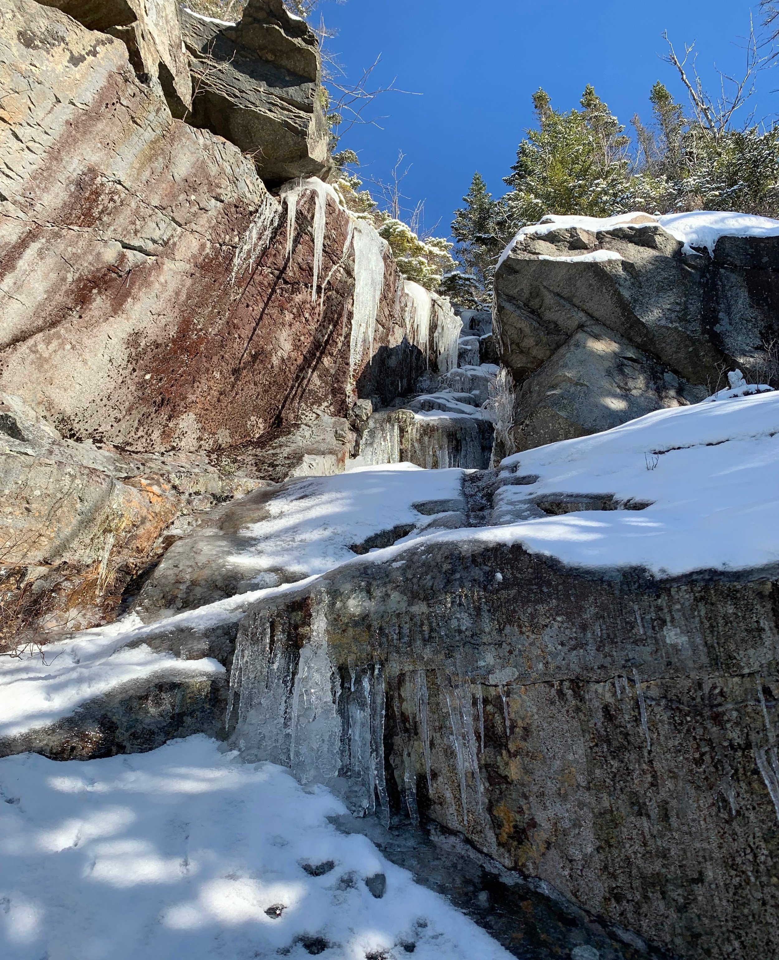
Frozen chute along the face of the slide
After ascending the small boulders and rocks as one would a slippery staircase I was right out and onto the slide itself, the views out to Moosilauke and the Kinsmans grew more vast with every step upward. Every ten feet or so I’d stop throwing ice axes and kicking steps into the ice to gaze up at what lay ahead, assuring that I chose solid ice, the best and safest route to make my ascent. I recalled thinking about how there was a day in my hiking past where I was extremely uncomfortable with heights and ledges and things, perhaps the sharp spikey bits attached to my boots and in my hands helped grow the confidence but I just focused on where I was and where I had to ascend to, disregarding any ice that I had already crossed over and giving thanks that it had itself clung to the bare mountainside in aiding my ascent.
It’s such a satisfying sound to hear the “chunk” of ice axe pick biting into good ice, making it very clear what doesn’t sound good clearly does not warrant your trust and needs to either be thrown harder or in a better location to find more solid ice. The ascent of these rock faces was one of the most satisfying yet, much more ice and much less snow than I was used to.
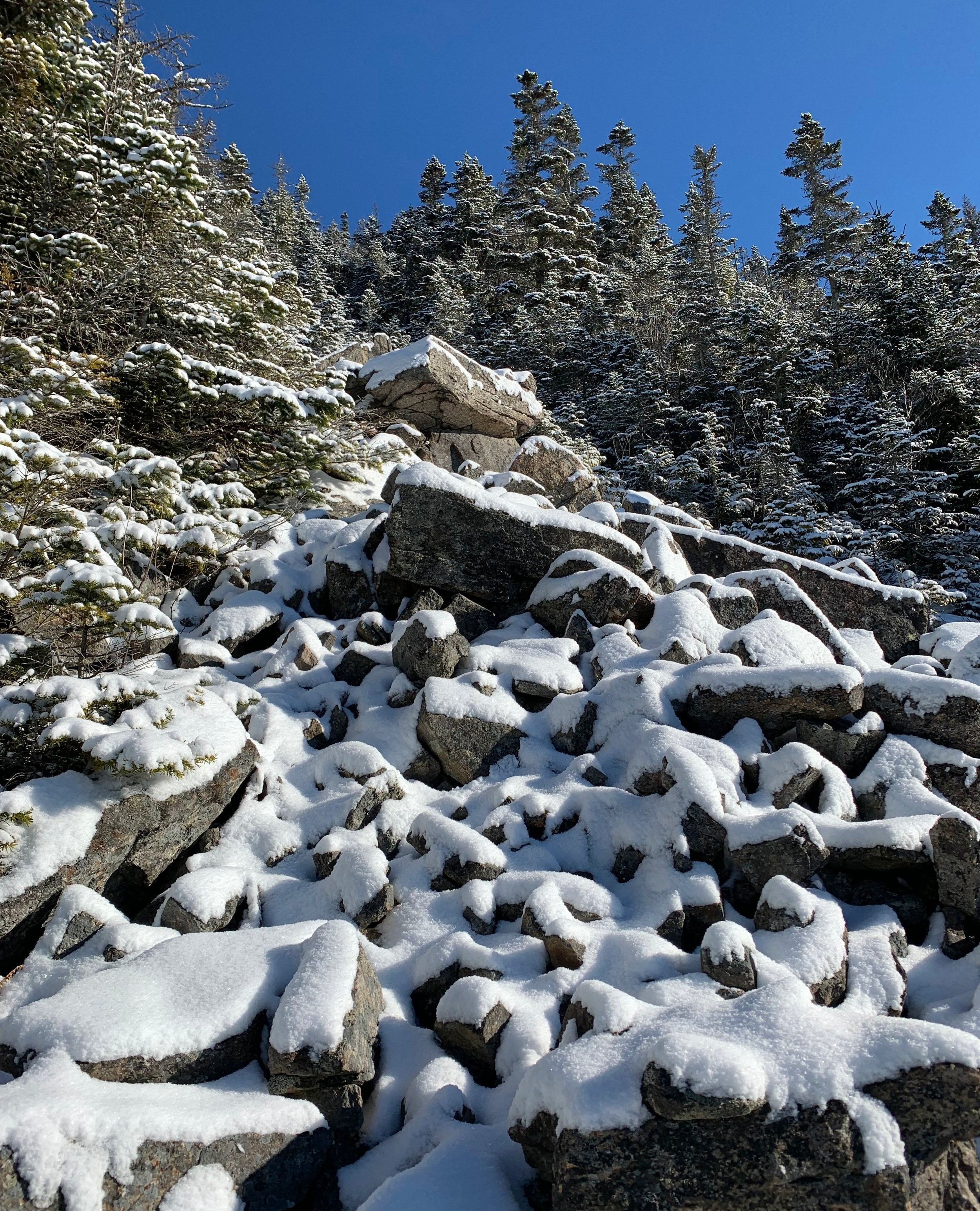
One of several boulder fields
I had read that this 1883 slide was becoming revegetated and in its’ path was broken up into several smaller slides which the climber could connect by trekking through short patches of fir and various other bushes and small trees, as it was winter and there were no leaves to contend with, the going was fairly smooth in these sections.
From the bottom most set of ledges leading to the middle section there was a wall of ice flow which I had read about, as this year had not provided much more than rain and freezing temperatures the ice wall was already full-on; about 10’ in height at the middle (where I had been ascending) and tapering on either side. The right side terminated in thick conifer tangles, left looked a bit more promising and could even see snapped branches from other climbers who had similar thoughts. With the safety of a smaller climb and more trees around to catch me had something gone awry, I placed axes and made good use of the crampons climbing the solid, resin-colored ice column.
The slide continued to taper as I ascended and before long could see the final headwall of the slide, at parts there was free flowing water coming directly from the moss and I could finally get a glimpse of the rock which lay below the ice sheet; lichen and moss in shades of red, green, black and brown streaked the rock showing how treacherous a climb of this slide would likely be in warmer weather.

Hit the ledgy rocks leading to Mt Liberty’s summit
Following the top of the third main section of rock face it seemed as if I was tracking along a herd path or perhaps remnants of old slide which had grown in, the bushwhacking grew fierce and thick! Balsam fir covered in the previous night’s dusting of snow made the going slow and my neck seemingly covered in every snowflake which fell from the trees above. Knowing how far I had come and that the open summit rock was really not that far above my head, I stepped and pushed, inching my way through the entanglement of thin branches, often times using the helmet on my head as a sort of battering ram to get through the brush – all I could do was laugh at the predicament I currently found myself and know that it could not last forever.
As if a reward was given for my perseverance, I could see more and more open light just up ahead so I angled my trajectory right at it, even just to have a moment to stop and look around without needle-like branches tearing at clothing layers.
What I stepped out onto was about mid-height of another slide in the ravine! This slide far different from the previous open rock slabs which I just climbed was made of millions of weathered and cracked rocks and boulders all piled up and of course coated with last nights dusting of snow. It seemed as if each step onto these rocks could set them in motion and send them all as bowling balls down, clearing another swath of trees and beginning a new landslide. Several of the rocks I climbed around instead of atop were nearly the size of cars, not knowing how cemented those were in place made me a bit nervous, I nearly tip toed around those hulks.

Nearing the summit!
Back into the dense forest for another bit that I would rather forget, this time for perhaps 75 feet which seemed like a mile, a long, slow, agonizing mile. I was beginning to see towering ledges and edges of jagged boulders far overhead though, I secretly wished that if I could simply ascend one of these boulders then maybe, just maybe I could be above the web of fir instead of crawling on my belly through it.
With blue skies and minimal wind in the air I was finally able to ascend to a spot to bask in the sunrays and take in the views of neighboring Mt Flume, which appeared as if I could almost reach out and pet its spine-like ridgeline that stretched out toward the mountain in which I was perched. The slides on Flume had never appeared so bright against the dark of the forest surrounding the bare western slope of the face.
Unfortunately I was merely on an island of ledge and to get to the series of rocks that I thought may help me gain the summit I had to dive one more time into the dense fir forest, such is life! I gave thanks for the glorious weather I was having, it is true that if conditions were worse, windy or with precipitation, I likely would not have climbed that route, opting to rather climb right back into bed. But I had good weather, spirits remained high and who could beat those views? On I climbed to my next set of ledges.

Cliffs of Cannon from Mt Liberty
There were a few points I had to swing my leg high and put a little extra trust in the ice axe placement to haul my body up those rocks but before long I could at least see up the series of growing rocks – scrambles and climbs that all seemed do-able, and most importantly would get me one step closer to topping out and beginning the descent back to my warm car via a well-used, blazed pathway.
With perhaps 200’ remaining of rock climbing to stand at the 4,459’ summit, I damn near teared up when there grew signs of past hikers – an actual herd path cut into the low-laying spruce, a tunnel carved into dense scraggly alpine growth to guide my remaining steps to the summit, I had done it.
With the summit completely to myself for several minutes, I soaked in as much of the sun as humanly possible, the views were fantastic also; Washington and the other Presidential’s sprawled out, caked in white; Cannon, Kinsman’s, Wolf and Moosilauke; Bondcliff’s stood as jagged and rugged as ever; not much was to be seen north, beyond the mass of Little Haystack; to the south Mt Flume was a stones throw away with the mighty Chocorua poking up just beyond.

Tools at the survey marker atop Mt Liberty
It was nice to see the boot tracks atop the summit snow while it remained desolate and silent – all mine for the moment. There was evidence of a chaotic summit earlier in the morning, which I was thankful to have avoided. Dog tracks dotted the human tracks which came and went from every direction, I chose the northerly direction to intercept the Liberty Springs Trail and back to my salad which was waiting patiently for my safe return.
What started out as an icy decent quickly turned into rocks in top of rocks with rocks sticking out of the snow, it appeared the ice had melted the further down I descended and off came the crampons, switched out for Hillsounds which I could stand to break on open rocks, those are easy to fix.
Reflecting on my day during the trek out, it was a marvelous climb, one I am glad to have done in early winter conditions after seeing the colorful slime which adorns the open rock slabs – that stuff is often more slick than bare ice itself!
I have long believed that each time we step out onto the trail, there are a multitude of reasons to find (and be shown by nature itself) as to why the path we find ourselves on is always the right path at the right time.
Overall stats for the day:
6.55-miles
6hr 11 minutes
3,917’ elevation gain
Mount Liberty - 4,459’