
The Captain
Aptly named due to its uncanny resemblance to the Half Dome of Yosemite, this rocky feature rises abruptly from the Hancock-Carrigain col and with seasonal forest roads all gated and repurposed as snowmobile routes, approaching this peak makes for a long journey from any direction, for those who want to visit ye craggy ol’ Captain.
Ideally, this off-trail ramble would have begun from the Sawyer Pond Trailhead, located several miles west of US Rt 302, near Crawford’s Notch. But with a majority of the seasonal forest roads in the White Mountains either gated or left to the snowmobilers, also acknowledging I just had several months to utilize these roads in return for a shorter, more direct approach, yet never jumped on the opportunity, it was obvious that subconsciously I had been waiting for snow to fall to attempt this craggy, little knub.

Kancamagus sunrise
For the better part of the morning commute to the Kancamagus Highway, I was silently hoping the DOT crews had enough time to get snowbanks pushed back along the roadway. Although not a traditional trailhead where hikers can get their vehicles into a parking area, generally the western terminus of the Sawyer River Trail (FR 158) does see some snow removal - enough to shove a car or three off the highway, at least.
A gorgeous sunrise was forming between the trees of the Kancamagus as final touches were made to gear and clothing layers before setting off at 7:07am. With snowshoes on mountaineering boots from the start, depths were looking hearty in the Sawyer River lowlands. Trekking along a deep boot track, thankfully these prints ended just beyond the crossing of the Swift River.

An icy Swift River
Following several sets of tracks, I stepped cautiously as the snowy pillows topping the river boulders were all flattened from the previous traffic from earlier. The crossing itself was moderately easy, the Swift River ran shallow enough that, with waterproof boots, a dipped toe in the icy flume would not end a day in the woods.
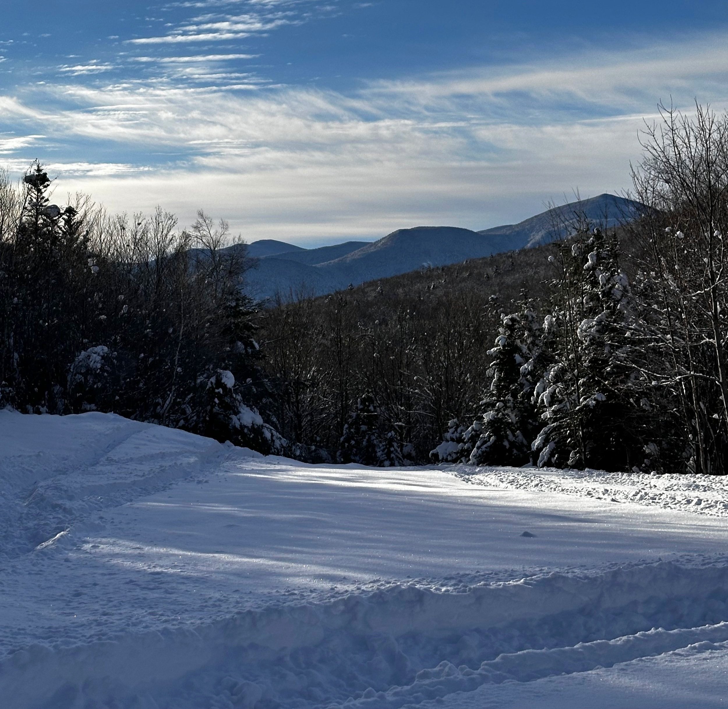
Beyond the Swift River, I followed alongside a ski track, peering side to side for a morning moose encounter - only a few older hoof prints were all I found in the snow this morning. At 0.6-miles into the Sawyer River Trail, the Nanamocomuck Ski Trail enters on the right, with this mergence the old railroad grade transitions into the Meadow Brook snowmobile trail.

Sawyer River Trail, or the Meadow Brook snomo corridor in winter
The corridor, only seeing traffic from one skier along with two or three sets of sled tracks, the snow was somewhat compact, offering relative efficiency while traversing the Sawyer River Trail. Nearing a wetland area, Greens Cliff becomes visible to the east, while cliffs of East Huntington dominated the westerly expanse. Occasional glimpses of a snowy Mount Carrigain and Signal Ridge appeared straight ahead, through a frame of stately conifers.
As the sun continued to rise alongside Greens Cliff, the 8° morning air slowly warmed as well. At 2.5-miles into my trek, I had reached my first main junction: join the Hancock Notch Trail to the left, or follow snowmobile tracks to the right - which would form nothing but a long winded approach to FR 86 (I’d be trekking the old FR 86A corridor), better indicated on some maps as Livermore Road, an old logging branch which is used by most to access The Captain, whether rock climbing its massive southeast face or ‘whacking to the top.

Sun rising next to Greens Cliff
Briefly, I broke trail down the Hancock Notch Trail, keeping an eye for a safe place to cross the Sawyer River. Opting to continue following the Hancock Notch Trail, reaching a spot where the path crosses a branch of the river, I managed to pick a route across on more snowy, pillow topped river rocks. Just to watch the pristine, white snow sink into the icy water and disappear into a haze - not yet frozen while not fully melted.
Thankful to have safely crossed this branch, I pressed on temporarily into trailless woods, aiming my trajectory toward an old log clearing or siding. At the northeastern edge of the clearing, an old road corridor can be discerned which crosses the North Branch Sawyer River on an old bridge.

Carrigain + Signal Ridge rise from the end of Livermore Road
Finally, I had navigated my way to the notorious Livermore Road, now the real approach to the Captain-Carrigain col can get underway! Following snowmobile tracks up a short, quick incline in the road, the sled tracks all ended at the 911 - Helipad landing site, which doubles as the North Fork snowmobile turn around.
Taking a good look at into the forest at the far end of the emergency landing site, I searched for, and found the continuation of the old logging road, which hikers can oftentimes navigate, bringing themselves 0.9-miles closer to the trailless summit, by staying just north of the North Branch Sawyer River.
A view into the Sandwich Range from the Helipad site
While certainly more of an old trail or road corridor earlier into the bushwhack of old Livermore Road, it was overall followable with some care, despite a few quick scrambles in which to locate its continuance. At a point where most online maps show the old route terminating, it does appear that it crosses a small drainage and hits a wall of spruce and fir, but checking slightly upstream can help locate a narrow sliver of herd path corridor.
Alternating between tight spruce/fir and relatively more open, easier to traverse woods, I tried to pick an elevation contour which had a friendly, welcoming forest and stick with it. But navigating these dense woods turned into an endless series of climbing up around a feature, just to drop back down 20-30’ to pick around downed spruce or some other obstacle.

The trailless forest, at some points thicker than others
Nearing the end of the North Branch ravine, The Captain can be seen at any break in the canopy. At one point, before beginning a dizzyingly steep ascent up the “headwall”, toward the Captain-Carrigain col, a boulder can be scaled which affords a staggering glimpse of the mountain’s sheer southeast cliffs.
One set of ledges were encountered while ascending up to the col, thankfully, being so early in the winter season, their ice flows have not fully formed, making ascension much less tricky. Even through the steepest section, the forest was tight but never featured any thin, spindly spruce that becomes woven together with other branches to really halt all forward progress.

Gazing up at The Captain
While the forest made for relatively efficient travel, the debacle of today’s excursion was contained high overhead in the conifer boughs. Trying to be mindful of what lay awaiting the slightest jostle, I carefully bounded hither and thither, attempting to not shake loose any powder from their omnipresent evergreen boughs. A Gore Tex shell goes a long way to shed the cascading plumes of snowfall, however, in a similar fashion to Chinese water torture, a person such as I can only laugh it off for so long.
A wave of relief hit upon cresting in the col. Wasting no time, I continued up seemingly stacked blocks of mountain mass; mammoth blocks of broken earth lay toppled, seemingly torn from its neighboring block. At one point, I looked to the left, looked to the right, and determined that the best route was right up a chute formed in the bedrock. Using sturdy roots and rocks with an individual crampon point from the Tubbs Flex Alp snowshoes, I hoisted myself slowly and methodically up the icy chimney.

Close-up of The Captain, SE face
The sunshine was visible off to my left, near the cliff face, wanting to press on toward the summit, I concluded that I would pay a visit on the descent. Up several more bumps in the mountainscape brought me to the summit. After being pummeled by snowballs for the past two hours, I raced to put on a fresh set of layers with fresh gloves for the descent.
A sip of tea would have to do for the summit celebration as any energy bar would have to defrost in a pocket before devouring. Following my ascending tracks, the downclimb always seems to go so much faster, of course its all downhill, but navigation is reduced to simply following snowshoe tracks, knowing this set of tracks terminates back at my awaiting car.
With great excitement I rejoined the old Livermore Road, although traipsing through churned snow was hardly any more efficient nor satisfying than if I had to completely break my own trail.

A steep, wooden ascent
Standing at the edge of the Sawyer River, I looked at where I had crossed several hours earlier and as this is written, I am still uncertain if rock tops were even used to cross the first time; all signs of snowy, pillow top had dissipated back into the icy waterway. Thankful for high Gore Tex gaiters and Gore Tex mountaineering boots, I placed the first snowshoe step into the river, at which point any slush contained in the river slurry instantly froze and clung to the underside of the snowshoes.
Once across the Sawyer River for the final occurrence of the day, I muttered a quick “thank you”, and began performing “ultra-math” in my head for the coming 3-mile slog out. Ultra-math is the brainstorm (quite literally a storm of thoughts in the mind, often had with variable coherency) which occurs many miles into an ultra running event where the mind begins playing with decimals and fractions, breaking the remaining mileage from current location to finish line down into quarter-miles, tenths-of-miles, even playing with thirty-seconds of a mile if the mind gets desperate enough.

Trekking back out the Livermore Road corridor
Perhaps its a coping mechanism to distract one’s mind from the grueling, sometimes painful situation we find ourselves in. One by one, landmarks passed during the morning we recounted and checked off. With ease, I navigated the sloppy footing and dilapidated snowy pillows to find myself at the far side. With 0.3-miles remaining, placing one snowshoe in front of the next was becoming a task. Even standing roadside with my Subaru in sight, all I wanted to do was sit down wherever I found myself at that moment.
While I knew those desires to be nonsense, I cannot think of a time following a winter hike where a car seat and fresh set of clothes had ever felt so good. I think I would like to do this hike again in warm weather, and by utilizing the Sawyer Pond trailhead, allowing enough time to poke around and search for the climbers camp, if anything remains.
Overall stats for the day:
12.17-miles
7hr 39 minutes
3,150’ elevation gain
The Captain - 3,520’