
Taum Sauk (Missouri HP)
Said to be more of an elongated ridgeline than a mountain range with prominent summits, Taum Sauk Mountain resides within the Saint Francois Range, and is the highest natural point found in the great state of Missouri. Unlike several neighboring ranges, which are formed more from erosional forces, the Saint Francois Mountain range is the result of volcanic orogeny.
After trying to set up camp at a seemingly abandoned US Forest Service campground, we settled on warm (free) showers, and half of a watermelon each, to replenish the unending bead of sweat which dripped from our noses. As we sat beneath a shade tree, scooping watermelon from their rind bowls, we hoped for a gentle breeze to break the stickiness of southern swampland. Deciding that the evening was still too young for sleep and sticking to sweaty book pages while trying to read just sounded like more misery, we reluctantly packed up all the camping gear we had just set up. Using the motion of the Subaru to capture a taste of wind gust in the open windows, we continued westwardly as the sky now began flickering with bright strobes.
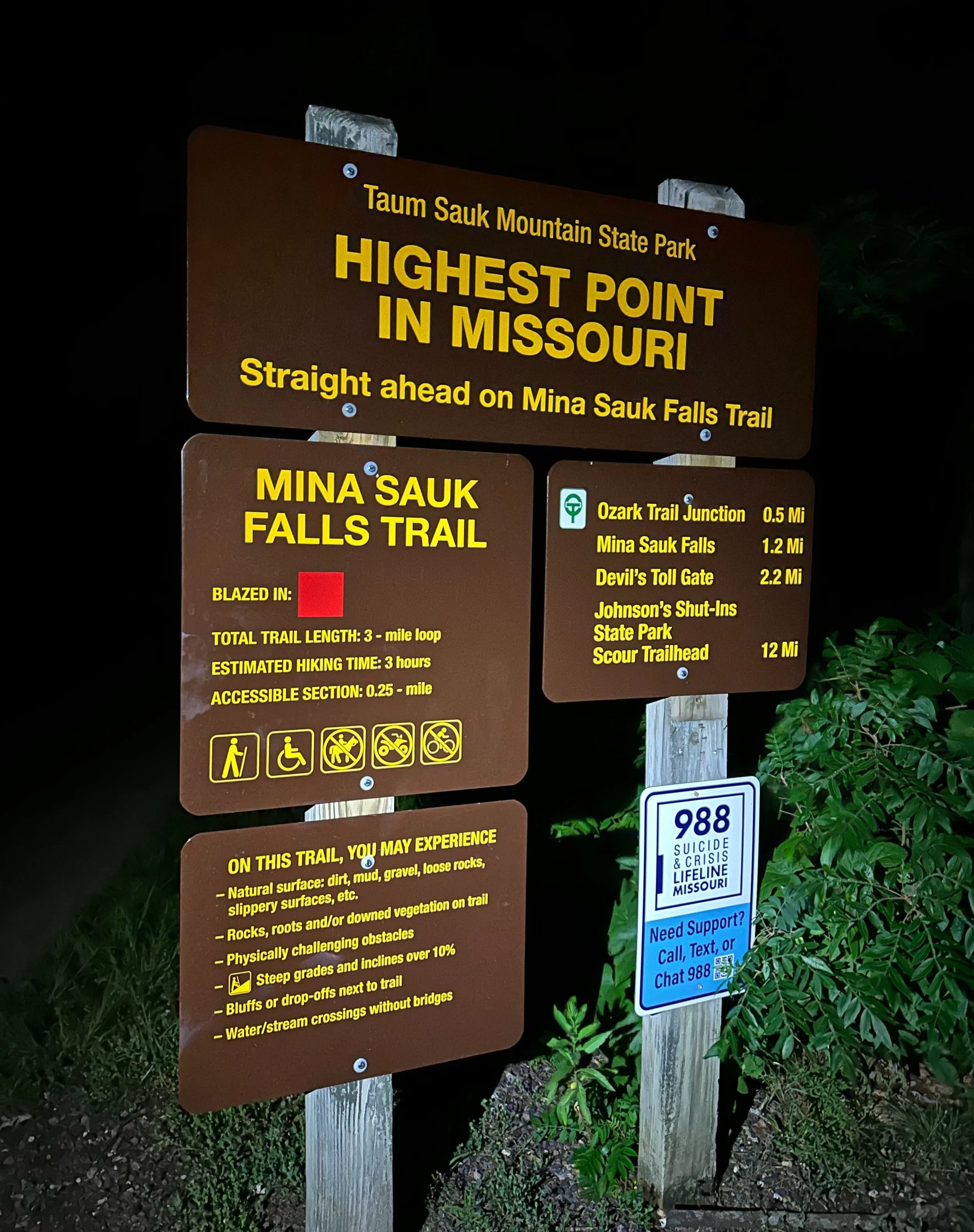
Hiker trailhead kiosk
As the mountain mass rose high before us, while approaching from the southeast, bright flashes from one of the oscillating radar towers dominated our view toward Taum Sauk, but was minimally obtrusive once driving up the mountain, as the light source was blocked by the low, forest canopy.
From the town of Arcadia, we turned onto a state highway labeled simply “CC” on road, and topographic maps. Immediately, the asphalt roadway begins climbing. Along the shoulders of Vail, and Russel Mountains the road traverses, passing a brightly flashing tower along its course. For nearly four-miles, the CC road winds up the hillside, even passing a small pull-off where visitors can stow their vehicles briefly and walk on foot along a narrow section of decking, for a glimpse at the surrounding hillscape from atop Russell Mountain (1,726’).

Along the accessible portion of Mina Sauk Falls Trail
The night sky was fully dark upon our arrival at the state high point; a large, asphalt parking area can be found for guests near where the footpath terminates. An information kiosk is found prior to embarking on the footpath section - this contains anything a hiker would need to know regarding blazes and markings along the pathway, distances to various nearby destinations, important contact information and phone numbers, as well as what hikers should expect while out roaming these trails.
Here, the Mina Sauk Falls Trail is mentioned; this 3.0-mile loop trail guides hikers to the highest waterfall in the state, given our 11:05pm arrival to Taum Sauk Mountain, we made a simple out-and-back - from the hiker trailhead lot to the summit, and back. Alternatively, the long-distance Ozark Trail can be found just south of the high point, affording longer loops for visitors wishing to see more of the Missouri landscape. With headlamps on, we set off along the sidewalk into the dense, mountaintop canopy.
From the trailhead, we could hear guests at the nearby Taum Sauk State Park campground, which, while hidden from view, thanks to a lush, mixed forest, it did sound as if we had other visitors behind us throughout our nighttime summit ramble. We assumed the bright flashes were simply heat lightning off in the distance; while we were able to visit the state high point area, we unfortunately were not afforded the fair weather required to visit some other surrounding pathways, and destinations.

Summit boulder of Tauk Sauk
From the trailhead kiosk, a 0.25-mile stroll atop the handicap accessible trail brings visitors through the wooded mountaintop to a small terminal clearing where the high point can be found. Following an easy walk with an insignificant amount of elevation gain, visitors to Taum Sauk are welcomed with a stone plaque placed in the treadway, this announced our arrival to the summit of Taum Sauk Mountain, and the Missouri state high point. Found adjacent, a large, pink-hued boulder evidently signifies the true high point of Taum Sauk.
Around the broad, summit area, a standard park bench, and wooden summit register box has been placed by the Highpointer’s Club. Sometimes mailboxes, metal ammunition boxes, or PVC pipe segments, these “canisters” found atop many states high points often contain summit register notebooks; into which, hikers can log their ascent of the peak, and recount interesting details from their mountain ramble, leaving tales, or navigational clues for subsequent hikers.
From our nighttime perch atop the high point of Taum Sauk Mountain, we could watch the distant lightening grow with intensity, apparently heading our direction; hearing only distant rumbles, we thought of our descent but saw no immediate threat. After several minutes spent admiring the summit area, and watching inquisitive eyes dart through the open woods, we retraced our steps back to the hiker trailhead.

Summit plaque marking the state high point
While we were able to gaze down upon a stunning panorama of city lights, there is no argument that the Taum Sauk State Park, state high point, and hiking trails should obviously be visited in daytime. Had we visited with more daylight remaining in our day, several loop hikes may have been embarked upon; even a short, side trip to the lookout tower would have made this wooded summit somewhat more desirable. A daytime gaze southward, from Russell Mountain, would have been lovely without the constant strobing from the nearby tower.
Departing the high point of Missouri, we were promptly met with sideways-blowing sheets of rain; earth-shattering thunder boomed all around as we tried to navigate through the tempest, only to pull over at a roadside trailhead (for the Ozark Trail) several miles beyond, to sleep in a cramped driver seat while we overnighted the thunderstorm - thankfully, we did not find ourselves atop the Taum Sauk mountain mass when the blinding winds, torrential rain, and car-thumping thunder came rolling into town.
Overall stats for the day:
0.47-miles
24 minutes
23’ elevation gain
Taum Sauk - 1,772’