
Backbone Mtn (Maryland HP)
Also depicted on most maps as the Hoye-Crest of Backbone Mountain, this 3,370’ rise in the mountainscape can be found along the western border of Maryland. Driving southward, from the high point of Pennsylvania, we traced the Virginia-Maryland state line until reaching the hiker trailhead parking area several hours southward.

Darkness settles in as we begin a climb up Backbone Mountain
Roadside, along the winding US Route 219 we found space for several vehicles along the northern shoulder. The trail up Backbone Mountain resides in Virginia for much of its course up the broad ridgecrest, only entering Maryland for the final several, rugged rods before reaching the recognized high point of Maryland.
From where we parked, a brief trek of 0.1-miles brings hikers to the entrance of an old logging road, a spur trail can be found climbing a short, steep embankment, effectively cutting off minimal distance. The Maryland High Point Trail begins climbing steeply, directly along the broad western-aspect of Backbone Mountain. Serving time as an old logging road, the wide, rugged footpath begins ascending steeply, soon emerging to follow along a high fence.

Ascending the Maryland High Point Trail
As the trail now swings away from the open, residential construction, and back into the dense forest as it slabs the northwest face of Backbone Mountain. Swinging onto the ridgecrest proper, signs and blazed trees continue to guide the way as the Maryland High Point Trail meets a brushy, old woods road. Joining this old corridor for the remaining ascent, more signs show the direction to various points of interest.
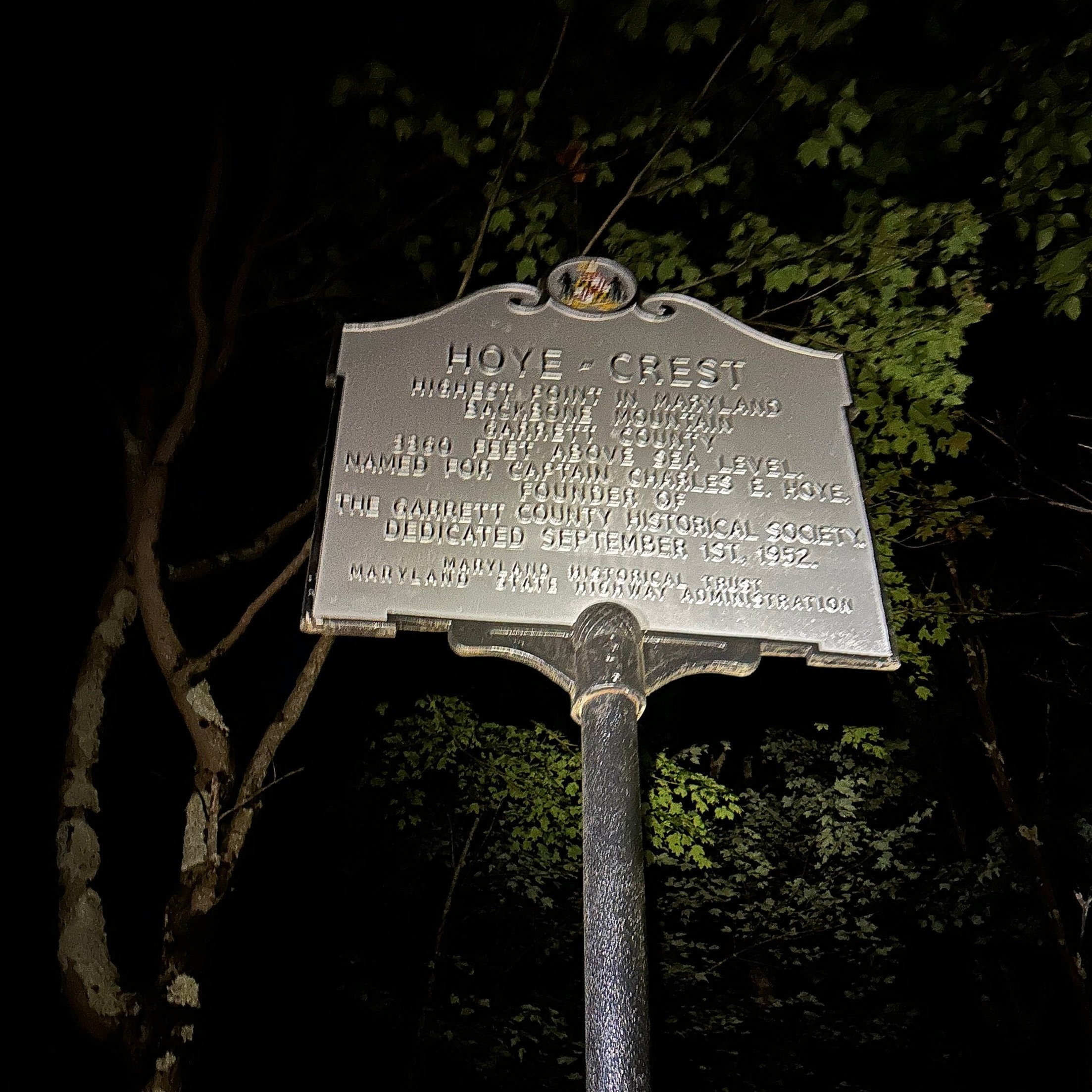
Hoye-Crest historical marker
Following along the wide, grassy trail swings along the ridge, finally emerging at a rock pile, picnic table, Highpointer’s Club matte black mailbox, and a tall, historical plaque, which explains the historical context of the Hoye-Crest. Several state high points contain mailboxes which protect a summit register; a notebook which hikers can sign into, logging their ascent, and leaving brief tales of their climbs for subsequent visitors.

MD/WV state border monument
As we arrived in the still of night, with a full moon looming high overhead, we tracked eyes, which in turn watched our every move with intent. After several hair-raising moments trying to discern how ferocious our nocturnal friend may be, we determined the eyes to belong to a docile, white-tailed deer, a fine fellow to share the high point with.

High Pointer’s Club summit register
After a brief stay atop the high point of Maryland, we retraced our steps down Backbone Mountain, stepping off once again to follow a rough, rocky route along the ridgecrest, to a peculiar concrete benchmark which represented the Maryland/West Virginia state border. Lots of interesting trinkets exist around the summit area for high point seekers to find, there is much history to uncover around the Hoye-Crest of Backbone Mountain.
Once we roamed, seeing all we felt we could around the high point of Maryland, lastly, we paused to gaze at the massive, brightly lit, full moon before descending back to the highway, to press-on into a westbound moonlit drive.
Overall stats for the day:
2.40-miles
1hr 25 minutes
738’ elevation gain
Backbone Mountain (Hoye-Crest) - 3,662’

Signs guide the way to the state high point