
Mt Anderson + Mt Lowell
Generally, to climb a mountain we need countless variables to go right, while only one to go wrong, keeping us from reaching our summit; commute to the trailhead, gear in proper working order, adequate sleep & nutrition, trail conditions (especially in winter) and of course, weather are but just a few.
These are a couple of 3,740’ trailless mountains; Mount Lowell being the better known, more photogenic of the two - thanks to its massive, colorful rock slides and gashes adorning its western face, which cannot be ignored when viewed from its 4,680’ neighbor, Mount Carrigain.

Nancy Pond Trailhead
I’ve wanted to climb these two peaks since I first stood atop Mt Carrigain - that October day in 2019 when I completed the New Hampshire 48, New England 67 and New England 115 - all simultaneously atop Mt Carrigain. It was then that I really got my first glimpses at the rock slide-streaked mountainside, I have been researching routes ever since.
Had Sawyer River Road been open at the time of my ascent, on Friday, I would have opted for that route, as that was where a majority of my mapping interests had been confined to. Naturally, I had perused over the idea of ascending from Nancy and Norcross Ponds, making for a long out-and-back.

Logging road grades of Nancy Pond Trail
With snow conditions in the backcountry as favorable as I had been finding lately, I thought Friday might be a good chance to have a go at bushwhacking to the top of these two peaks. Daytime highs had softened the snowpack while nighttime lows in the teens had created a rock-solid surface in which to cruise on snowshoes in the early hours of morning.
That was the plan; I’d park at the Nancy Pond Trailhead on US Rt 302 and hike generally in a westerly direction until standing pondside, then commence the off-trail adventure. I’ll skip somewhat fast to Nancy Pond since I did a quick write-up for Mt Nancy, Mt Bemis and the overall Nancy Brook Scenic Area several weeks ago - you can find that link right here.

Deep snowpack at ~3,000’
Beginning at 7:33am, I set off with snowshoes from the start, from the Nancy Brook Trailhead; the sight of a packed snowshoe trench was just what I was hoping for, that would help make for quick, efficient travel over the first several miles of logging road walk. The trails down low had gathered 1-2” of powder atop the hard snowshoe track.
Despite the deep snowpack, most of the water crossings early on were completely open, crossed on bare rocks while the water flowed around, continuing downstream. Nancy Brook at 1.6-miles sounded like it was flowing harder than it appeared, this crossing was average depth; remnants of snow bridge remained while the middle was crossed atop bare rocks.

Crossing Nancy Pond with Mt Anderson just ahead
More good time was made ascending along the Hurricane Irene re-route, an area of steep switchbacks lined with gorgeous spruce. The brook crossing just below Nancy Cascades was completely covered over, intriguing with the sound of trickling water far beneath, well out of sight. Even Nancy Cascades was still shroud in a thick layer of snow and ice, only a small patch was exposed.
While ascending the switchbacks, to the south of Nancy Cascades, there is no doubt I lost the actual trail, I could not find a yellow blaze until higher up. While blazing my own trail, I ended up kicking snowshoe steps straight up and through what would have been several of the switchbacks, while the trail itself was completely unrecognizable.

Norcross Pond visible through the open forest, ~3,300’
I thought I found an area that skiers had tried to descend but upon further inspection came across an area of recent wet avalanching which had refrozen over during one of the nighttime temperature drops - once I realized what I had been standing on I traipsed off that slope as quickly and lightly as I could, thankfully the once cascading snow layer had now refrozen into a bumpy, solid mass.
Finally locating a yellow blaze, I followed it onto a more gentle grade for the last switchback which eventually led me into deeper powder along the edge of upper Nancy Brook. Several areas which, in warmer months, would be simple waterway crossings were looking more like sinkholes today - flowing water was visible perhaps 5-6’ down, showing just how deep the snowpack is around 3,000’.
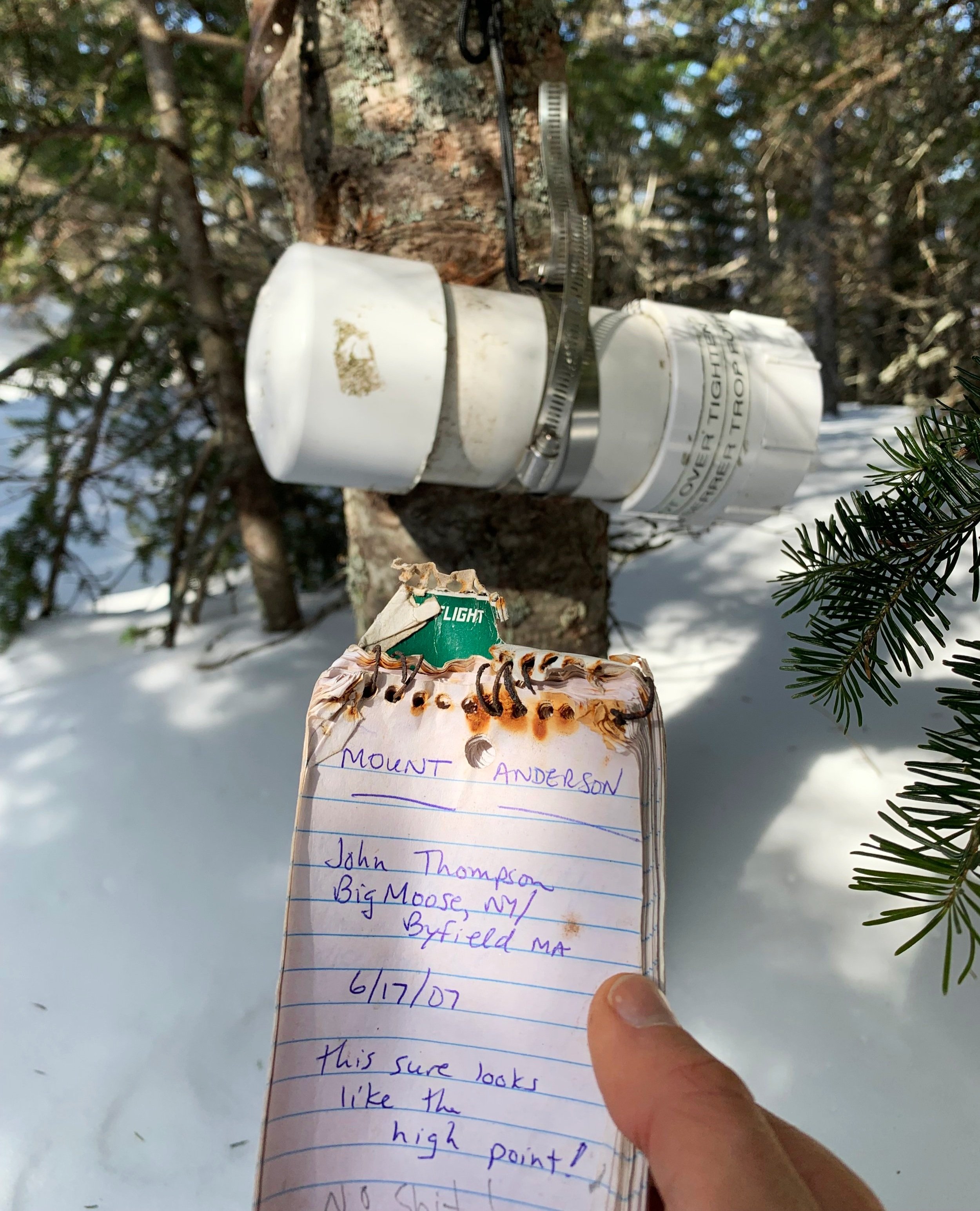
Mount Anderson summit
At 3.5-miles the shore of Nancy Pond is reached; today it was a sheet of windswept snow crust. With the 5-6’ snowpack back in the forest, I’d bet the pond was adequately frozen but I wasn’t pressing my luck with a remote body of water - I trekked around the open perimeter of the pond toward the northwest corner - to where I would enter the trailless mountainside.
I was hopeful for a stretch of easy going forest but soon into the bushwhack was greeted with young evergreen boughs and small spruce traps which gave way to a spindly, stabbing, dense spruce twig canopy which was slow going but not the worst I have ever experienced. All the while I could see light through the trees into the near distance, which kept me hopeful for better forest just up ahead.

Signal Ridge + Mt Carrigain from Mt Anderson
At ~3,300’ the dense forest did open up; the understory was clean and flattened off with the snowpack, the spruce traps abated, conifer branches stopped poking and suddenly I could stand upright and allow myself breathe deeply - this was the mature forest I had been searching for.
While the mountainside of Mount Anderson certainly grew steep (this turned out to be nothing compared to the grade descending to the Lowell col), the forest was open and snow was a hard crust, making for fast, efficient climbing. Reaching the high point I found the canister tied to a fir tree with paracord as the bracket had broken.

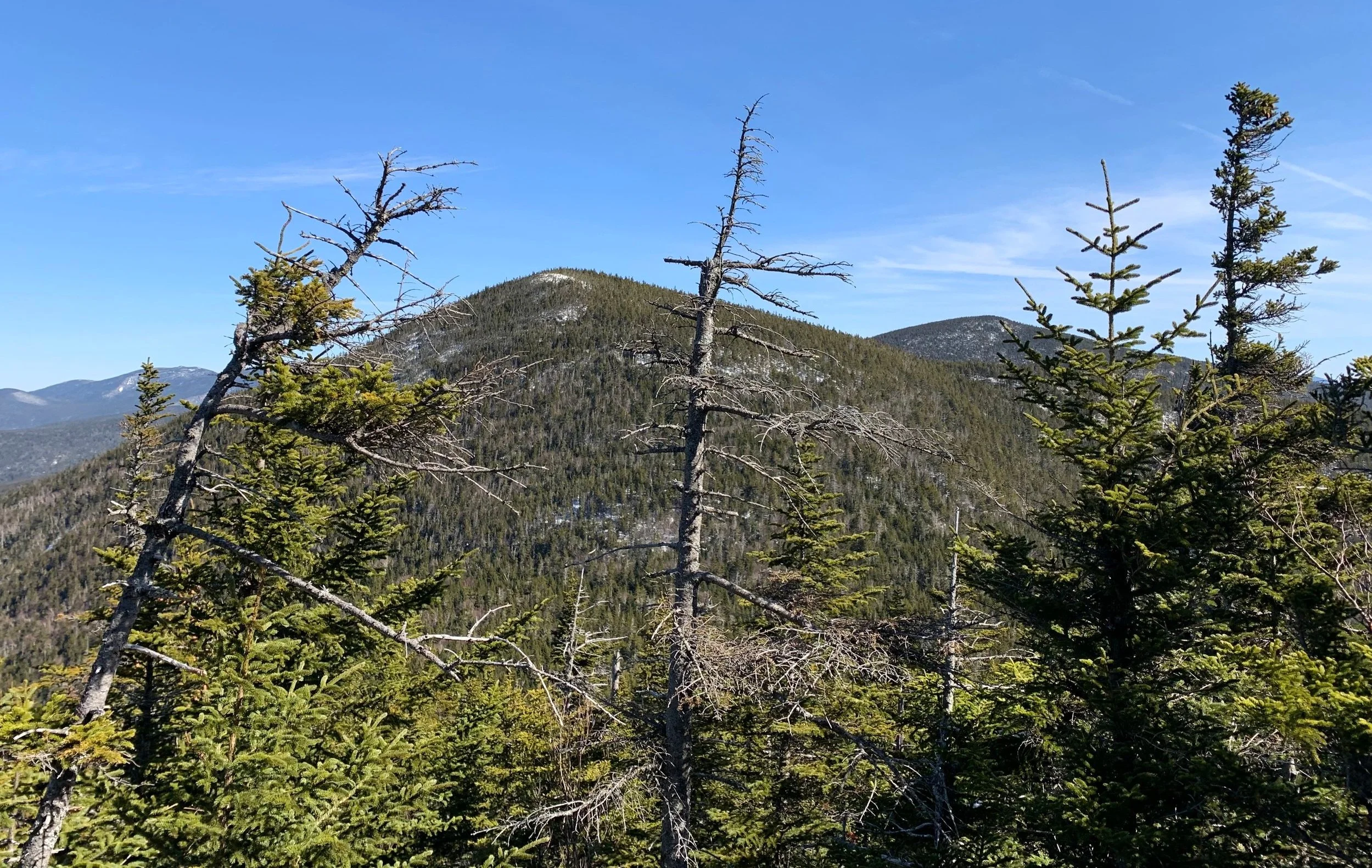
Mt Lowell from Mt Anderson
After signing in and logging my ascent I made my way over to the beautiful southwesterly view; my next objective, Mt Lowell was completely visible to where I could see its open hillside appearing rather inviting. The unique view of Mt Carrigain, Vose Spur and Signal Ridge took my breath away, the completely monochromatic mountainside with its slides and high points highlighted a brilliant white.
These two peaks may have been tied for my favorite mountaintop vistas of all time; however, Mt Lowell may have taken the win by a small margin simply because while atop the deep summit snowpack I could look back toward Mt Anderson, from which I had just trekked, Mount Washington and the white-capped Presidential Range poked up from behind Mt Anderson - a view I will not soon forget.

A patch of pleasant forest enroute to Mt Lowell
As I was saying, the descent off Mt Anderson was one of the steepest I have encountered while not slide climbing; descending ~500’ in 0.2-miles down to the col, it took all of my effort to keep snowshoe crampons stuck in the hard crust. Occasionally, the forest grew thick but it wasn’t too difficult to look ahead and steer ones path toward a more pleasant type of forest.
Reaching the col, the area was bright and open; I had read reports of high moose activity in this boggy area but did not come across any today, perhaps they don’t favor this 6’ snowpack and frozen water bodies.
Mt Anderson from Mt Lowell
I spent basically the entire ascent of Mount Lowell waiting for the forest to open up but it really did not - at least not along the direction I trekked. Spindly spruce twigs were pushed aside, several isolated spruce traps were encountered and nearing 3,600’ the conifers grew bent and twisted in various directions - shaped by forceful Pemigewasset winds whipping through Carrigain Notch.
From the col I ascended Mt Lowell in a southwesterly direction, once reaching the ~3,600’ shoulder I took a more southeasterly approach, veering toward the actual high point. Meandering through this upper forest was never atrocious, just thick conifer branches and slower going. When the summit was nearly in view I came to an “open” area with the jaw-dropping panoramic view that I could never grow tired of.

Mt Lowell summit
I used quotations to describe this upper open area as it was during my wintery visit, I was standing atop low spruce and fir. I could see the highest evergreen needles occasionally sticking through the snowy crust, obviously I walked around any exposed needles, but this had me wondering just how much plant matter existed beneath this supportive crust layer.
The high point of Mount Lowell was not hard to locate; I signed into the summit register and took in the epic view of Signal Ridge, Carrigain and Vose Spur as I drank some warm tea. This is a beautiful, remote mountaintop which I will certainly be returning to in the future, during warmer months. I do have plans to ascend via The Chute route up Mt Lowell, after all.

Mt Washington poking up from behind Mts Anderson + Nancy
Departing the summit around 10am and retracing my steps for a quick descent back to the col, the snowpack was beginning to soften and get sticky in the mid-morning sunshine - there is not much more I dislike than springtime snow balling up and sticking to snowshoes or spikes, rendering their points nearly useless - this put a little more pep into each of my steps to get home.
The southern slope of Mt Anderson was softening up quite a bit; remembering the open forest above 3,300’, I made the call to bag the summit and simply follow the 3,550’ elevation contour line, swinging counter-clockwise around the summit cone to regain my ascending tracks.

Tight forest nearing the Lowell-Anderson col
The descent back to the pond was quick, perhaps because already I knew the harsh, dense bushwhacking which lay between my current location and easy trail trek back to my car. Following my snowshoe tracks for easy navigation I pushed through and eventually the grade leveled off, finding myself back at Nancy Pond.
While the snowpack descending the switchbacks along Nancy Cascades were clearly more frozen today than on the day in which the surface had slid, nonetheless I carried my ice axe and was ready to self-arrest should the need arise. I stuck mostly to the switchbacks but once they disappeared into the treeline I made a straight shot down the steep slope, sticking close to trees in hopes their trucks would lock the surface snow in place.

Looking back up to Mt Anderson from the col
The sun felt great on the final trek out, wind was left in the higher elevations. With a fast paced trot to my step, I cruised off-trail as this springtime snow had yet to stick to the underside of snowshoes as it did while on-trail.
In a bit of a meditative state, it made me incredibly pleased to look back on the past few hours and realize that all aspects of today’s climb had worked out just as I had hoped, some even better than I could have imagined. The views are some of the finest I have ever had atop any summit in the White Mountains.
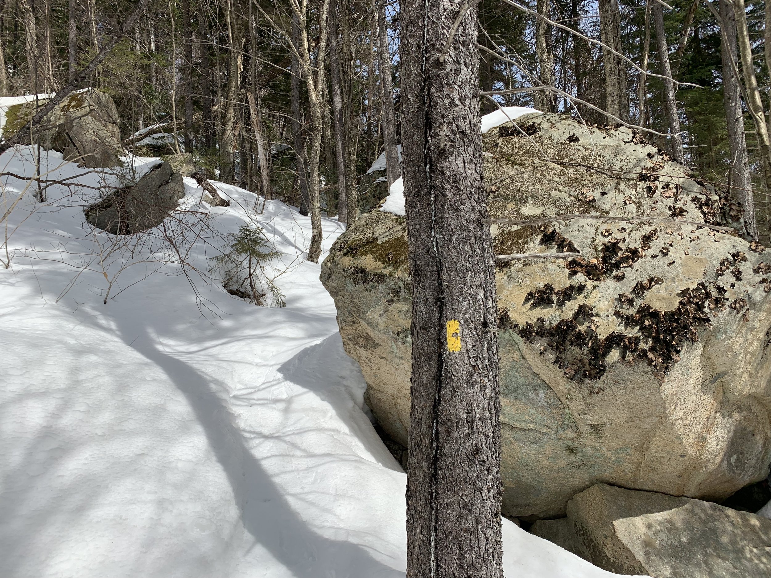
Boulders along the Nancy Pond Trail
Now we wait for springtime to melt the forest floor back to one solid piece of land on which to traipse. While I am hoping for more cold nights to keep the snowpack frozen just a bit longer, I know the inevitable slushy snow is just around the corner.
Overall stats for the day:
10.12-miles
5hr 19 minutes
4,245’ elevation gain