
Mount Greylock
After a late-night ascent of Rhode Island’s state high point, which had begun at 11:48pm and consisted of a quick, fifteen minute ramble, Alanna and I hopped back in our Subaru and made the 130-mile commute northwestwardly, toward Mount Greylock of the western Massachusetts.
The town was well asleep as we crept into Adams, Massachusetts; down a rather bumpy asphalt road - which reminded us of the worst frost-heaves one could anticipate finding around our own neck of the woods - we eventually pulled into a completely deserted Gould Trailhead parking lot. It was immediately obvious, given the ambient light, that the spotlight illuminating the 100-foot, granite memorial tower was plain to see all the way at the trailhead. In the back of a Subaru hatchback we drifted off to sleep, atop a lofty dog bed mattress, cocooned in thick sleeping bags we dreamt of clear skies for our early morning summit attempt.

Low grade of the early Gould Trail
We awoke just as the sky began to glow - to our surprise (thankfully), the weatherperson was wrong yet again, no rain, no fog - in fact, hardly any clouds sauntered across the sky. Neither of us anticipated a sunrise quite as colorful and lovely as we had received this morning: fuchsia pink faded into streaks of deep crimson red, orange sherbet faded into a gingery eggshell hue - the splash of color was beyond breathtaking, especially as it was viewed from the back of a vehicle at 1,375’.
From our stealthy trailhead camp spot, the Gould Trail would guide us 2.75-miles up the southeastern face to the 3,491’ mountaintop of Mount Greylock. With light packs, yet plenty of water, we departed, still scratching our heads as to how much “cold weather” gear might actually be needed for this state high point, as morning temperatures were now in full autumnal swing.

Crossing Pecks Brook
Initially, along a narrow, single-lane path for several quick rods, the Gould Trail soon joins a network of wide, old forest roads; several other trails intersect and diverge early into the trek, but seem to be well-marked with hand-painted signs, in addition to standard blue paint blazes. Before long into the hike, plastic DCR (Department of Conservation and Recreation) signage is encountered - the white text contrasts beautifully on the dark brown background.
Pecks Brook is crossed via an old wooden bridge at 0.12-miles, beyond this crossing the Gould Trail begins to ascend steadily. Briefly, the pathway veers northwardly before swinging back into, and following the northern side of Pecks Brook ravine for a majority of the climb. The lower elevation forest absolutely lit up as hardwood leaves of every autumnal hue drifted down, becoming audible as they cascaded through already bare branches and blanketed the footpath, what a sight!
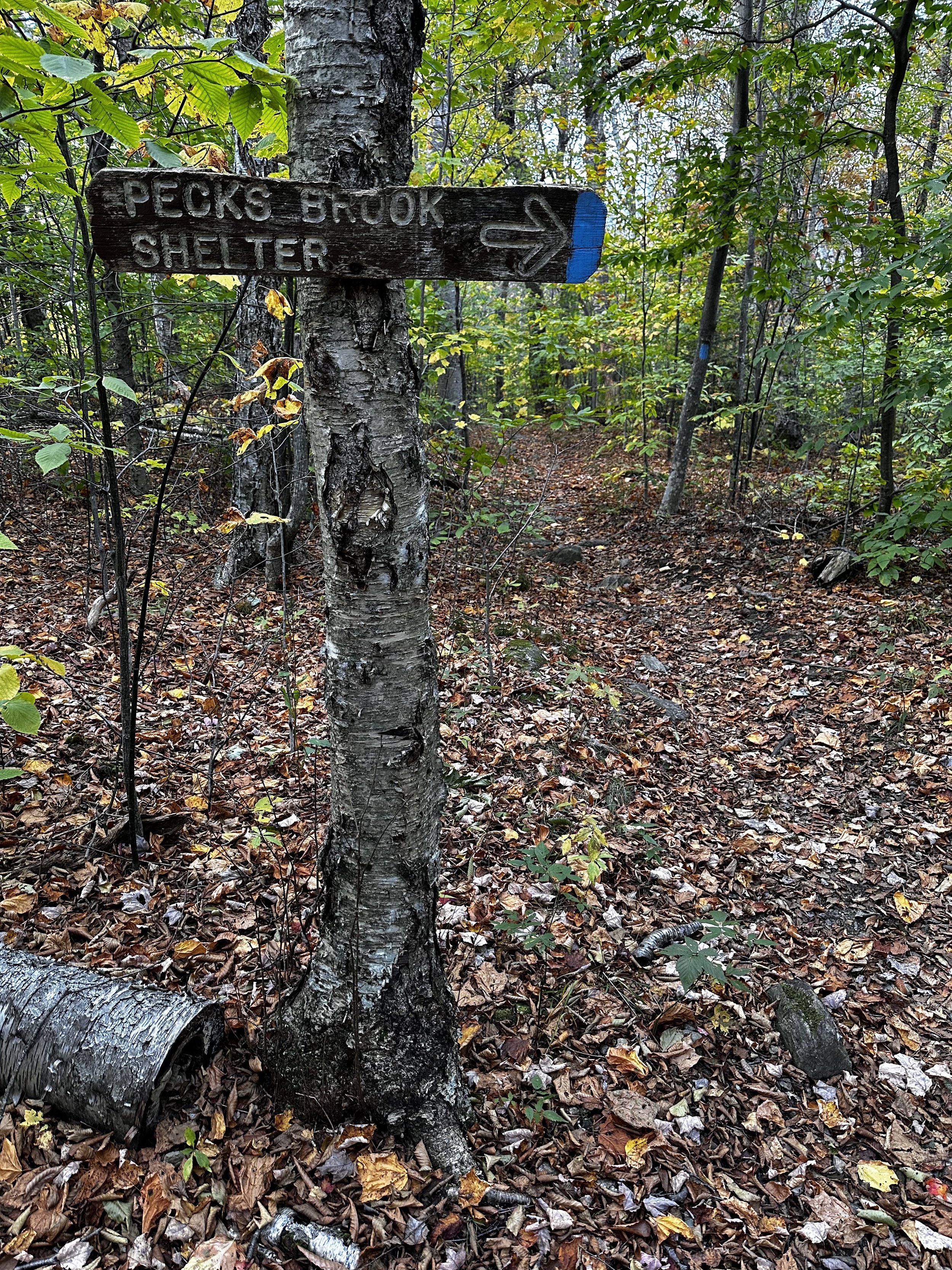
Pecks Brook Shelter spur trail
The Gould Trail becomes increasingly interesting as one climbs, albeit wet; the well-drained trail soon becomes rocky underfoot and somewhat slick with the morning dew and fallen leaf litter. Occasionally, the footpath shows glimpses into its past as the evidence of a graded roadbed can be found, the treadway resting several feet below the surrounding banks of earth; the trench of pathway appears cut to this depth and perhaps not caused strictly by erosion.
A faint path enters on the left as one ascends; this connector trail links up with the Cheshire-Harbor Trail to the southwest. Proceeding upslope, one soon encounters another short path, this one leading to Pecks Brook Falls, followed by a signed junction which guides toward Pecks Brook Shelter - all of which was not visited today on this trek of the Gould Trail.
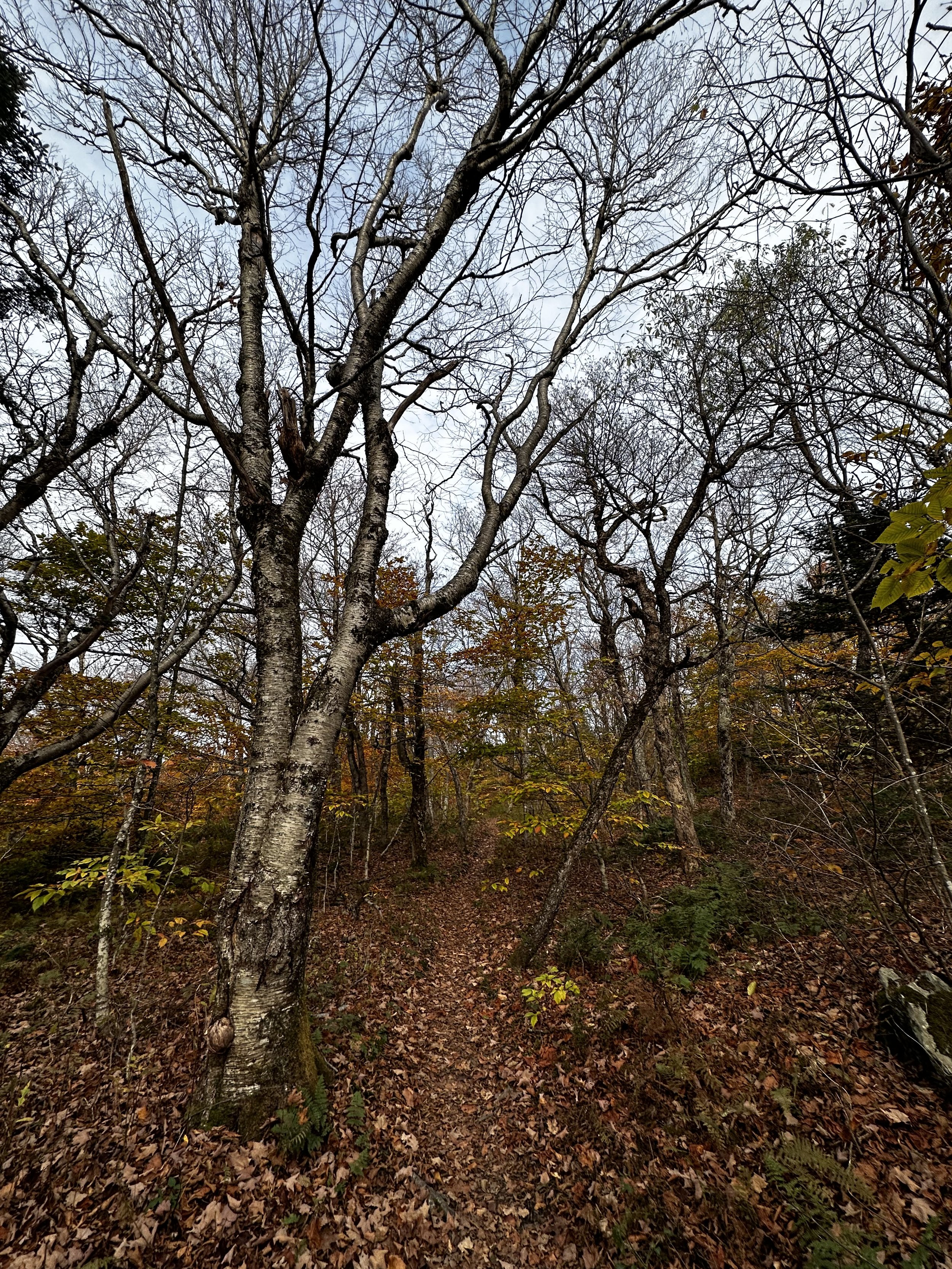
Beautiful hardwood glow from the upper Gould Trail
The Gould Trail continues to steeply climb for the coming 0.8-miles, crossing several minor drainages atop a relatively standard northeastern trail: roots, rocks, and leaves, all found in a rich soil matrix, abounding underfoot. As conifers become prevalent amidst the surrounding forest, automobiles can frequently be heard cruising the Scenic Byway, just ahead through the canopy.
At 2.3-miles into our hike of Mount Greylock, we popped out of the forest into the corner of a small parking area only a short distance south of the three-way auto road intersection. Here, the Appalachian Trail crosses and Gould Trail hikers switch from following blue paint to standard white AT blazes, signs also denote the path which leads to the summit.
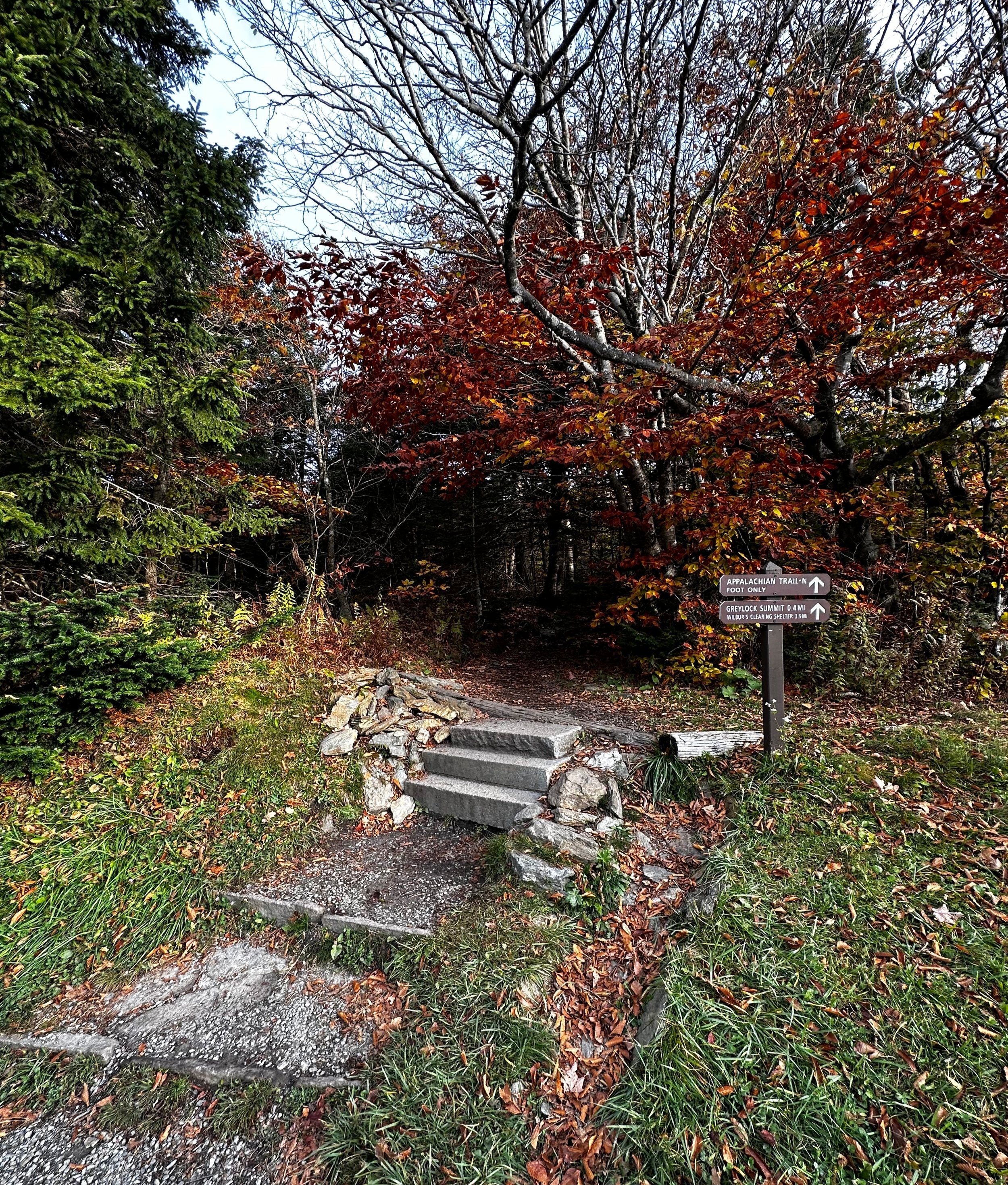
Joining the Appalachian Trail for a trek to the summit
Appearing as if to be an entirely different trail on a contrasting mountain slope, the Appalachian Trail shows its decades of foot traffic; being highly eroded, jagged rocks protrude in incongruous angles from the footway. The trail now navigates a primarily sub-alpine, boreal-style forest as it meanders toward the state high point. At 2.6-miles, several structures are encountered, the tallest of which being a television and communication tower at the terminus of the Overlook Trail. Very briefly, the route travels on asphalt before becoming fully-forested for the final tenth of a mile.

Final ascent toward the summit of Mount Greylock
Perhaps one of the finest vistas of the trek thus far can be found just prior to the final emergence onto Summit Road; a mere sliver through a picture frame of conifers affords a stunning glimpse toward the massive memorial tower. Many signs work to guide tourists and hikers to their respective destinations, ours was plain to see - just ahead was the memorial tower, interpretive information signs and at the furthest corner of the mountaintop to be found toward the east - a US Coast & Geodetic Survey station marker disc.
Emerging onto the high lawn of Mount Greylock, one can locate the 1930’s-built Bascom Lodge to the south, parking area to the north, and main summit area straight ahead, eastwardly. As the tower was not open to the public during the morning hours of our summiting, we strolled along a mostly quiet mountaintop; birds chirped as the warming sun cast rays into the treetops, some folks walked their four-legged companions and exchanged a welcoming “good morning!”. Before long, we searched the skies for a pack of buzzing bees, but to our dismay, all we found was a tourist illegally flying and hovering their drone around the tower structure - what an obnoxious racket those things make, and interesting enough, the rules and regulations are posted very clear for all to see around the summit area, choosing to acknowledge posted rules, however, I suppose, is a different issue.

Survey benchmark disc atop Mt Greylock
And while, we are absolutely not against drones (we admire the stunning cinematographic and photographic footage which can be captured by these remote crafts), but what bothers us is clearly seeing folks placing themselves and their individual experience in the wilderness to be above rules and regulations - most are in place for a very good reason. On Mount Greylock, the sound and frequency of a flying drone will have a highly negative impact on the native butterfly and avian species that are trying to be reintroduced to the region, not to mention the lack of respect it shows to other hikers and tourists.
An important aspect of standard Leave No Trace principal is showing respect for locals (wildlife and human alike) and others who use these lands. We just ask that we all try to educate folks in both the backcountry and frontcountry to local regulations put in place, as the reasoning behind various rules may not be completely obvious to all.
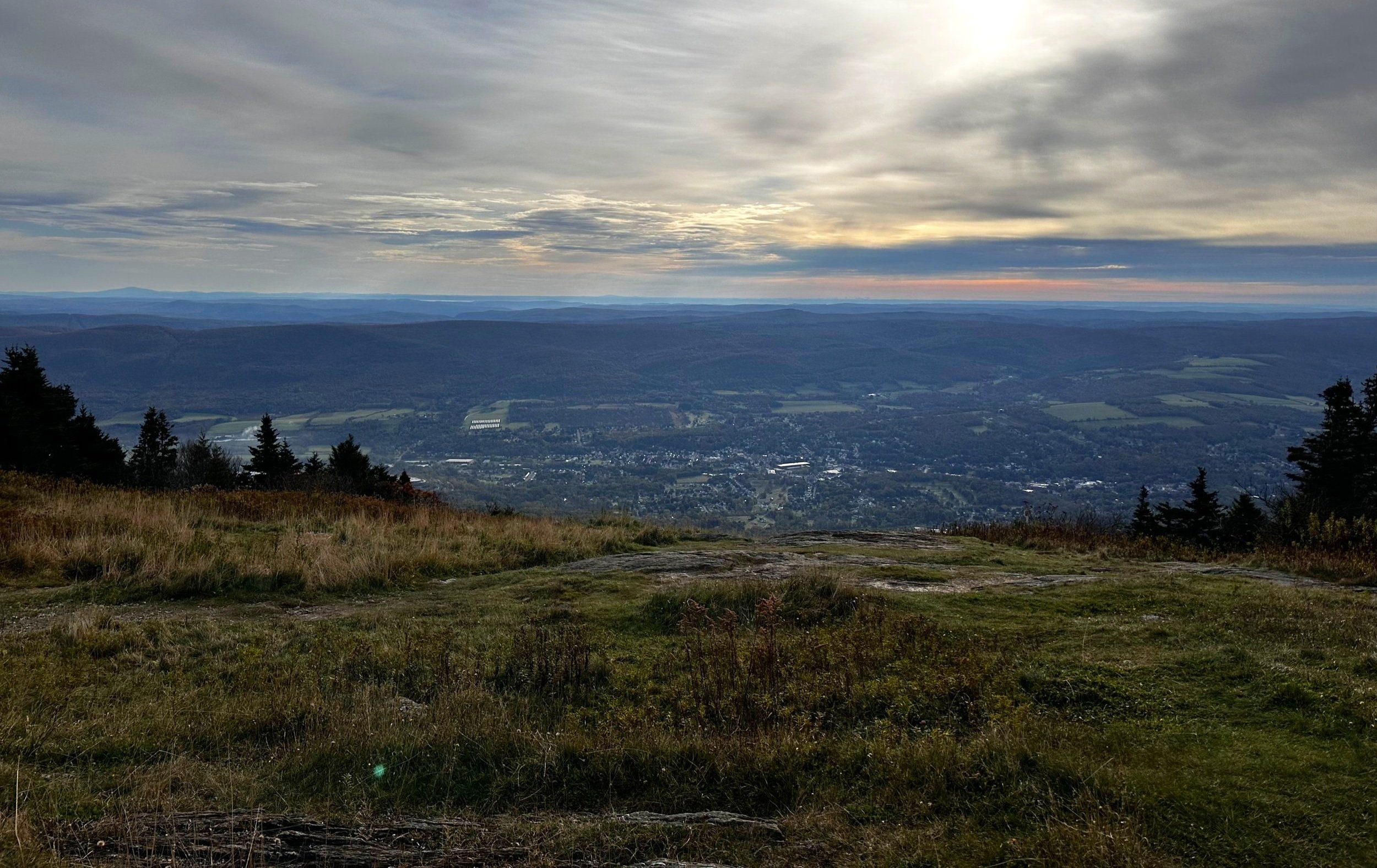
Eastward views from the top
Concluding our sunny jaunt atop Mount Greylock (and picking out Mount Monadnock in the northeasterly distance), we retraced our steps, stopping for photographs or any trailside explorations which to view miniscule mushrooms or other interesting fauna up close - since we found ourselves far from our White Mountain home, as if in a new world to roam and explore.
We returned to a completely full Gould Trailhead parking lot - which was hardly a surprise after all of the greeting and pulling over to let groups pass.

Looking back along the rugged Appalachian Trail section
“Short and steep”, is a fine way of describing the Gould Trail; a highly enjoyable ramble on the highest mountain in Massachusetts. However, given the sheer number of routes one could make from any of the trailhead parking lots, traffic on the Gould Trail was never bothersome or remotely close to Mount Washington on a holiday.
Get out and enjoy trails of any kind, Massachusetts certainly has many excellent hiking and trail running networks to be discovered… and we are just beginning to scratch the surface!
Overall stats for the day:
5.86-miles
3hr 18 minutes
2,260’ elevation gain
Mount Greylock - 3,491’
