
Mount Hor
“The right trail at the right time.” A saying encountered somewhere along my travels and trails; I believe it to be true more often than not, whether regarding trail conditions, the people we meet, or pushing confidence and skill boundaries - if one reflects on a hike, climb, or run, there is often a lesson to be learned throughout the endeavor, an ability improved upon, or just a good reason to believe we were in the right place at the right time.
Beginning at Willoughby State Forest
This trek through Willoughby State Forest was no exception; initially immersed in a dense cloud of foggy haze, we drove north on Interstate 91, along the Connecticut River Valley, before diverging northeastward through Burke, Vermont on Route 5. Delightfully, we found one other car in the Mount Hor Trailhead parking lot on the westward side of Route 5 at 6:45am.
Nearing the large trailhead parking lot, we exited the low-hanging fog layer into picturesque blue skies, complete with a million-dollar view along the notch formed between Mount Hor and Mount Pisgah, the deepest lake in Vermont streaked in a north-south direction between the two cliff-faced peaks.

Setting off on the old CCC road
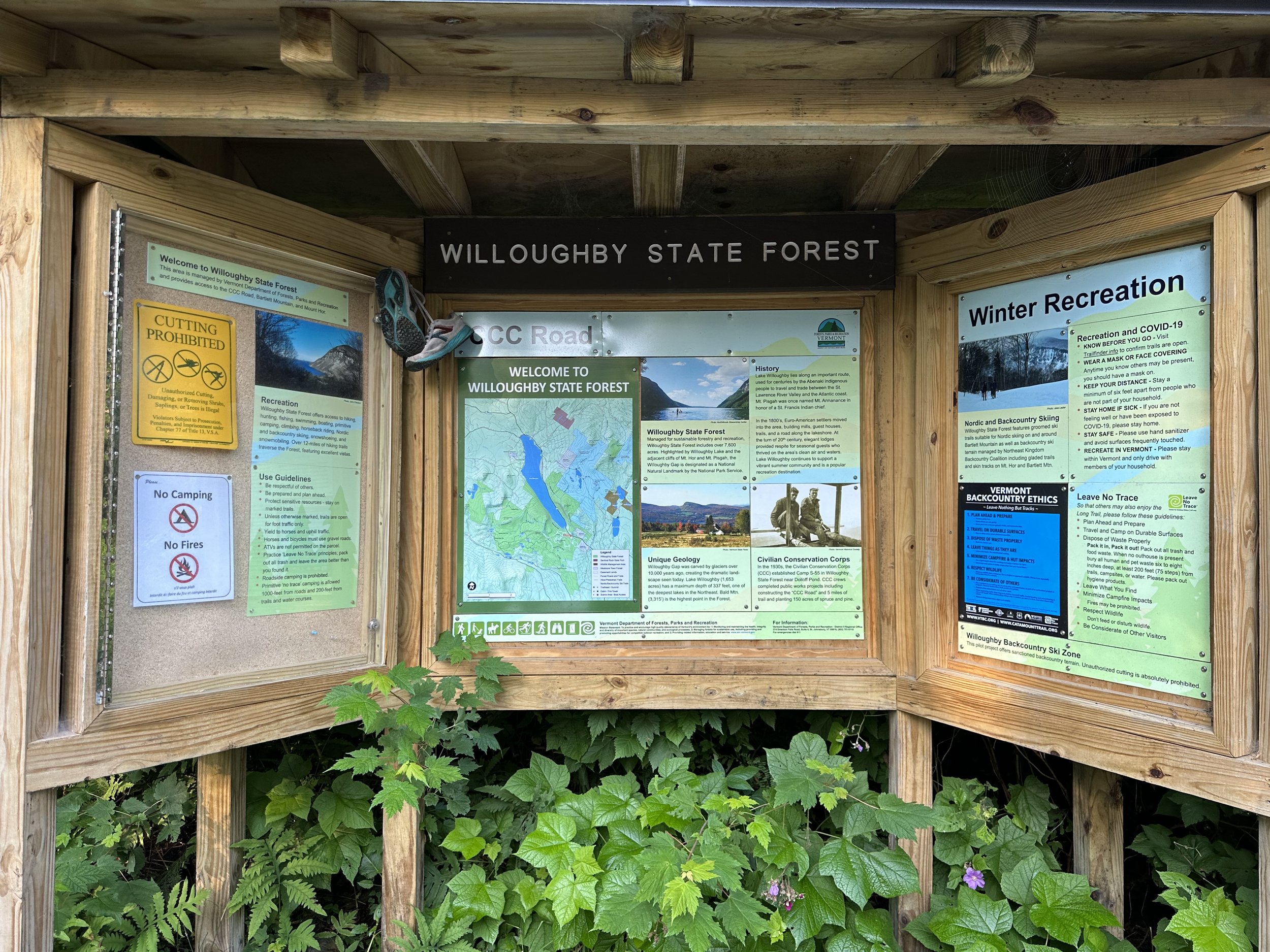
During the summer months the trailhead offers several porta-potties before embarking into the vast network of trails, all which radiate and diverge from the old Civilian Conservation Corps-built road; easy and stable footing comprised of dirt and gravel begin any hike from this trailhead. Before departing the parking area, it is advisable to take one final glimpse at the planned route upon the large topographic map found at the trailhead kiosk. Also located here are the Leave No Trace fundamentals, Vermont hiking ethics, and various historical photos detailing the works of the CCC in the Willoughby State Forest.
Along a gradual 10-15% grade, the old road climbs, making a tight northwesterly swing at 0.3-miles. From roadside, several signed cross-country ski trails can be found diverging, most of which feature color maps to indicate their direction. This morning, while warming up along the 1.7-mile road walk, we passed several dispersed tent campers who were utilizing various gated forest roads and small pull-offs for a quick night of rest, none of which had any fire rings nor amenities.

Hebert Hawkes Trail
While space can be found down the CCC road for several cars to park at the actual Mount Hor-Hebert Hawkes Trailhead, we preferred the gradual ascent for a warm-up on the short hike in, and a gravity induced cool-down jog on the trek back to our car. Before embarking deeper into the forest, the trailhead offers another kiosk with a similar topographic map and more historical factsheets alongside the aforementioned Leave No Trace and Vermont Hiking/Backcountry Ethics placards.
Several rods along the Hebert Hawkes Trail can be found a small trailhead register in which to log the anticipated route and amount of time one intends to spend in the backcountry. Utilizing these forms helps not only with Search and Rescue efforts - should the need arise - but also with advising the State Forest department as to which trails and areas receive higher traffic rates, this helps allocate budgets for maintenance projects and determine the volume of recreationists occupying particular areas.

Along the well-graded Hebert Hawkes Trail
Along an old woods road, the Hebert Hawkes Trail begins very gradually with a wide berth and beautiful dirt footing, occasional rocks emerge from the trail surface, but none become cumbersome nor problematic, this is a delightfully smooth trail at its onset. Various ferns, striped maple, beech, and loads of hobblebush provide a highly lush and dense, viridescent understory as the forest canopy looms high above.
As the trail swings northeastward, the original route of the woods road can be seen continuing straight towards Mount Hor, albeit significantly grown in these days with a dense understory, the current path, however, is unmistakable. At 0.4-miles since departing the CCC road, the Hebert Hawkes Trail begins a short series of switchbacks up the east-facing slope of the mountain atop a slightly more rugged trail bed; stone staircases and intentionally placed boulders aid in ascending while rock and log waterbars help to direct water off the trail, thus preventing soggy conditions which inevitably lead to increased erosion rates.

Nearing the three lookout spots
Several small muddy areas were found today, while nothing terribly slick or tricky, we trekked right through the mud as to not widen the pathway any further - often times steppingstones can be found emerging from the mud to help keep feet mud-free. Needless to say, the trailwork and maintenance on the Willoughby State Forest trails is marvelous and greatly appreciated.

Southwestward lookout
Just shy of 2,500’, the Hebert Hawkes Trail splits; a left turn here will guide hikers to the summit area and southwest-facing lookout, while veering right at this junction will lead toward the North Trail, with the North and East Lookouts just beyond.
While gaining the final elevation of Mount Hor, we trekked southwestward to visit the lookout first; here, we could spot Norris (2,543’) and Granby (2,382’) mountains nearby as the dense Connecticut River Valley fog layer we had driven through earlier in the morning remained blanketing the southern hillsides. As the pathway terminates at the lookout spot, we backtracked ~200’ to the well-tracked herd path we had spotted minutes prior. This unmarked path unmistakably winds toward the true high point of Mount Hor for roughly 250’, which is indicated with a sign and glass register canister, into which we signed and registered our accent of the low mountain.

Mount Hor summit
Following the well-beaten herd path back toward the main trail, we began now in a northeasterly direction for several minutes before reaching the main, three-way junction, a right here would lead back down to the CCC road - we continued straight. Traversing at a near-level contour, the path crossed several soggy sags, all of which were aided by steppingstones, but overall the pathway was relatively free of mud - a fine surface of packed dirt with the occasional root or rock obstacle to step over.
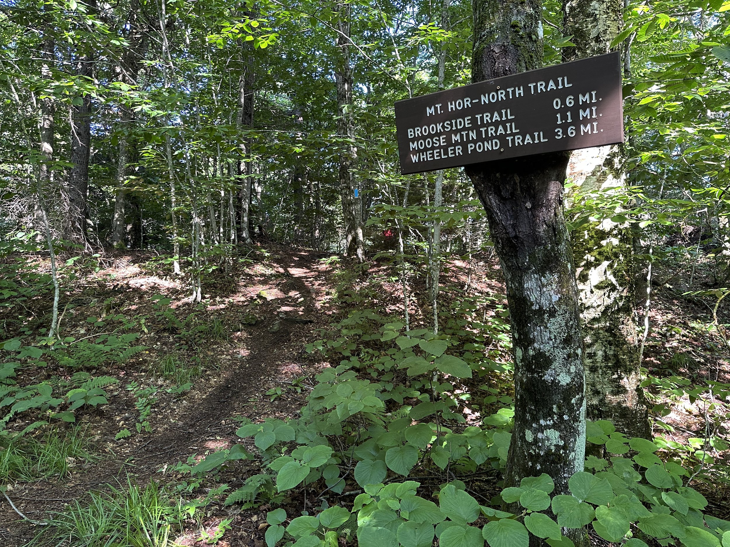
Passing the North Trail
In 0.3-miles beyond, the Hebert Hawkes Trail reaches the southeastern terminus of the North Trail, which we contemplated taking to reach Moose Mountain (2,359’) or the Willoughby Overlook for a slightly longer trek. Saving these further destinations for another day, we continued following the Hebert Hawkes Trail toward the main objectives of the day - the North and East Lookouts.
As the main trail splits, signs denote each scenic destination; with a brief downclimb, the east-facing vista can be reached with relative ease. From here, one can find a beautiful flat spot in which to rest, taking in the sheer cliffs of Mount Pisgah (2,756’) across the lake, the ski slopes of nearby Burke Mountain (3,260’) to the south are unmistakable, a very ghostly scene of hazy, White Mountain peaks rose up like teeth on a sawblade, far in the distance.

Southeastern Vista
Minor elevation is gained in which to reach the junction, veering northward will guide toward the North Lookout. With a slightly further downclimb and trek through the forest, much more space is available for other hikers to pass or take in a brief reprieve from the trekking. Framed by an old birch and several conifers, the striking view looks directly out toward the southwest-facing cliffs of Mount Pisgah, being so forested this time of the year, only the extreme northern end of Lake Willoughby was visible from this vantage point. The low ridge of Hedgehog Mountain (2,195’) and the domes of Goodwin (2,890’) and Bald (3,300’) Mountains were visible just to the left of the beautiful mass of Mount Pisgah.
To the north, beyond the end of Lake Willoughby could be found many peaks of Canada; from high up, at this vantage point, it is easy to assume this must be akin to soaring through the treetops, able to scan far into the horizon as one stands at the precipitous edge of the Northern Lookout. Retracing our steps was smooth sailing as we began passing and greeting other hikers beginning their adventures.

North Overlook spur path
Worth noting as well was the scene encountered at the east-facing Vista, as it went against all Leave No Trace principals and showed a complete disregard and disrespect for the wilderness and other visitors alike. From the junction we could spot a bright red hammock strung up, completely blocking the trail just prior to reaching the scenic outlook.
The occupants had recklessly left vodka bottles, beer cans, a bag of marijuana with a glass bong out on the ledgy rocks with open food still in the cook pot - we observed the scene as we passed by, determined to visit the beautiful lookout. The occupants, who had signed the register with their full addresses (out of state), were both completely passed out in the hammock and briefly stirred as we passed by, not trying to remain quiet for their sake. Beyond the hammock, occupying the entire flat landing area in which to enjoy the vista was their unoccupied tent, a piece of backpacking equipment which I had wanted to set out into the vast open air, to let drift atop the morning breeze, undoubtably an act such as this would hypocritically go against all Leave No Trace principals. We left the site as we found it, wishing the hungover duo a swift recovery and safe descent - needless to say, we were absolutely appalled at what we found this morning occupying the lovely eastern vista.

Mount Pisgah cliffs and northern peaks
A jaunt back down the Hebert Hawkes Trail was followed up with a brief swim in the lake and a self-guided tour along Vermont Route 5A, which traverses the eastern shore of the lake, offering a stunning and unique glimpse southward, back into the Mts Hor-Pisgah Notch.
With such unique geological landmarks and sculpted bedrock formations, the Willoughby State Forest is a decadent area in which to explore, each summit then leads curious minds toward other nearby peaks and old woods roads, a truly remarkable landscape in northern Vermont.
Overall stats for the day:
7-miles
2hr 43 minutes
1,775’ elevation gain
Mount Hor - 2,657’

Mount Hor + Mount Pisgah from Lake Willoughby