
Mount Defiance
After a proper exploration of the Mount Saint Helens National Volcanic Monument, and several fine waterfalls around the Cougar, Washington wilderness area, Alanna and I decided to route our west coast adventure northeastwardly - to visit the northern Cascades for a good, long glimpse at Mount Rainier.
With the Seattle skyline in our rear view, we joined the I-90 morning commute east; we had a layover of several days coming soon in the Enchantments Mountain Range and Alpine Lakes Wilderness region, but first - a hike to stretch the legs, soak in some sunshine, and get a brief taste of the alpine lakes to come.

Beginning along the Ira Spring Trail
Disembarking Interstate 90 for Forest Road 9030. Initially, this thoroughfare was paved, but as the road made a hard switchback toward the east - this paved forest road terminates at, and provides access to the Talapus Lake Trailhead. Our first destination would be found by continuing to the end of Mason Lake Road. Navigating the rugged and rocky (average condition for a west coast forest road) gravel road for 2.9-miles further, we side-hilled lower Bandera, and Little Bandera Mountains before reaching the rather large parking area for the Ira Spring Trailhead.

McCellen Butte (5,162’) rising tall
Several other parties readied massive packs, likely heading out for a multi-night stay in the backcountry. Before ever leaving the parking lot, our jaws were on the ground at the sheer, jagged pinnacle of McCellan Butte, across the I-90 highway. Bathrooms are available (bring toilet paper) at the western edge of the trailhead parking area; just beyond, the Ira Spring Trail #1038 begins into the woods as a wide, sandy tote path.
Graded for equestrian traffic, the wide pathway switchbacks eastwardly at 0.2-miles. Here, the grassy Putrid Pete’s Peak Trail proceeds straight ahead, providing a steep and rugged ascent of Putrid Pete’s Peak, from which some climbers will bushwhack along the knife edge ridgecrest to Mount Defiance, thence descend via the easier grades of the trails we chose to explore.

The beautifully graded Ira Spring Trail
Thanks to several sturdy, log bridges, we easily crossed several drainages, both of our minds pondering how good a dip in those sunny alpine waters would feel on the descent. At 0.9-miles into the trek, we met our first main junction - I had read reports of hikers still ascending the Old Mason Lake Trail, despite it having fallen into “unmaintained” status. Stepping over a log which acted as a barricade from the old footpath, we immediately felt a sense of remoteness as we gave up our wide horse path for a narrow, single track treadway which began immediately scaling a series of nine, tight, steep switchbacks.
With soft footing threatening to slip down the harrowingly steep mountainside, I could understand why the footpath had been closed, but did not know the real cause would be found just ahead. Reaching 2,800’, the Old Mason Lake Trail begins north/northeasterly, toward Mason Creek.
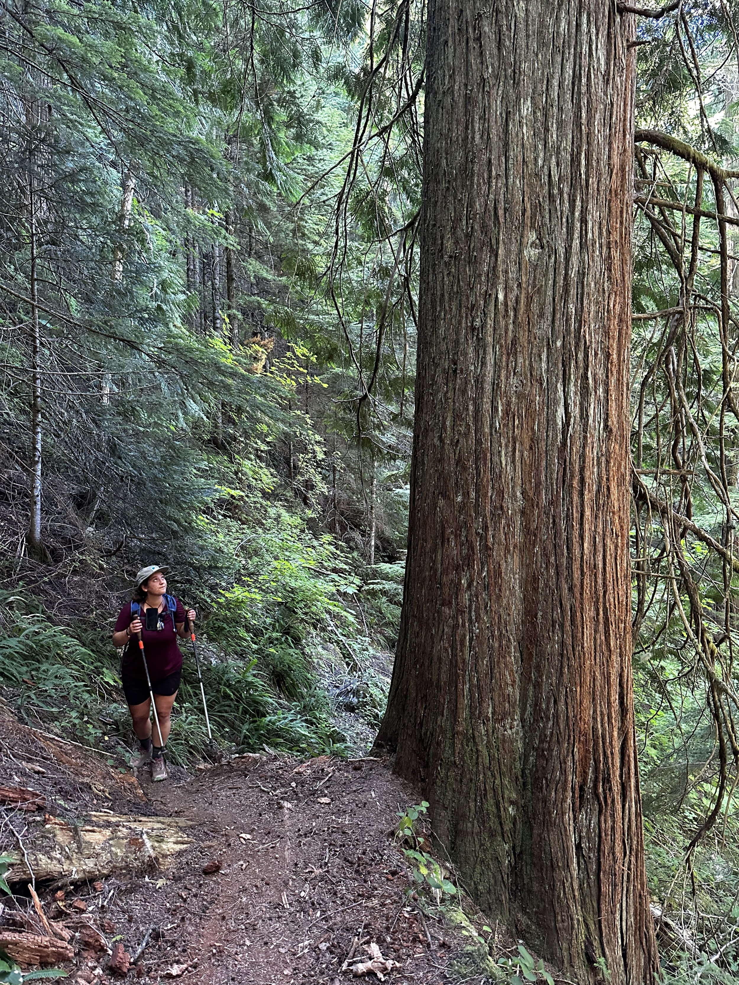
Massive cedars line the Old Mason Lake Trail
The footpath resumes its relatively wide trench as it enters a forest unlike any I had hitherto roamed: larger-than-life cedar stood all about the hillside. Many fine examples also lay toppled, likely downed from a microburst or hurricane in years past. This, I believe, is likely why the Old Mason Lake Trail had been closed, as there had been someone performing reportedly, “impeccable” trail maintenance in years prior to its closure; during our ascent we found magnificently massive trunks toppled and stacked - unlike a blowdown patch of northeast proportions, where young mountain fir works to clog any open space between fallen timber. Here, the forest remained overall tidy around any leaning or completely toppled trees.

Pleasant strolling along the old path
The forestscape had a very rich and moist air about it, perhaps due to the copious amounts of shade, with Mason Creek flowing nearby. Overall, the footpath was easy to follow, although in several instances I would have to look back to spot the trail, and then cast a gaze into the coming hillside to discern where the pine needle treadway led.
After meandering through the evergreens, hikers will encounter a vast swath of old rockslide devastation at 1.75-miles into the trek. Streaking far up the steep slope on climbers right, the Old Mason Lake Trail passes over the lower tail of the boulderfield. Climbing atop the jumble of angled boulders, it is not hard to discern a route made by prior muddy footprints on rock tops. Rejoining the woods for a short, yet rather steep pitch, the path climbs alongside roots and rocks, extra care should be taken when ascending atop any loose, sandy footing.

Navigating through the tailings of an old landslide
Reaching 4,150’ along the hillside, the Ira Spring Trail merges from the south - once back on the maintained pathway, it is not hard to see how this junction can be missed, as the Old Mason Lake Trail dives immediately behind a large boulder, downed logs have also been placed to discourage foot traffic on the old trail corridor.
Now following the Ira Spring Trail northeastwardly, a log-clogged drainage of Mason Lake is encountered; the lower shoulder of Bandera Mountain rises into view with several streaks of old landslide terminating at the water’s edge. Being a popular backcountry camping spot, a spur trail can be found which leads toward the privy. Conveniently, the shoreline of Mason Lake is rather long, offering many enjoyable, secluded spots for hikers to find a reprieve from the heat of mid-day sun.

Gazing toward the Bandera Mountains from Mason Lake
The Ira Spring Trail rolls along the wooded hillside; at 0.15-miles from lakeside, the Mount Defiance Trail #1009 is met, tree-mounted signs direct the way toward the main objective. Beginning with a low, rolling grade, the fine footpath soon begins a long ascent up a southeast ridge. A sense of scaling the ridgecrest becomes obvious as one can observe the terrain fall away on either side.
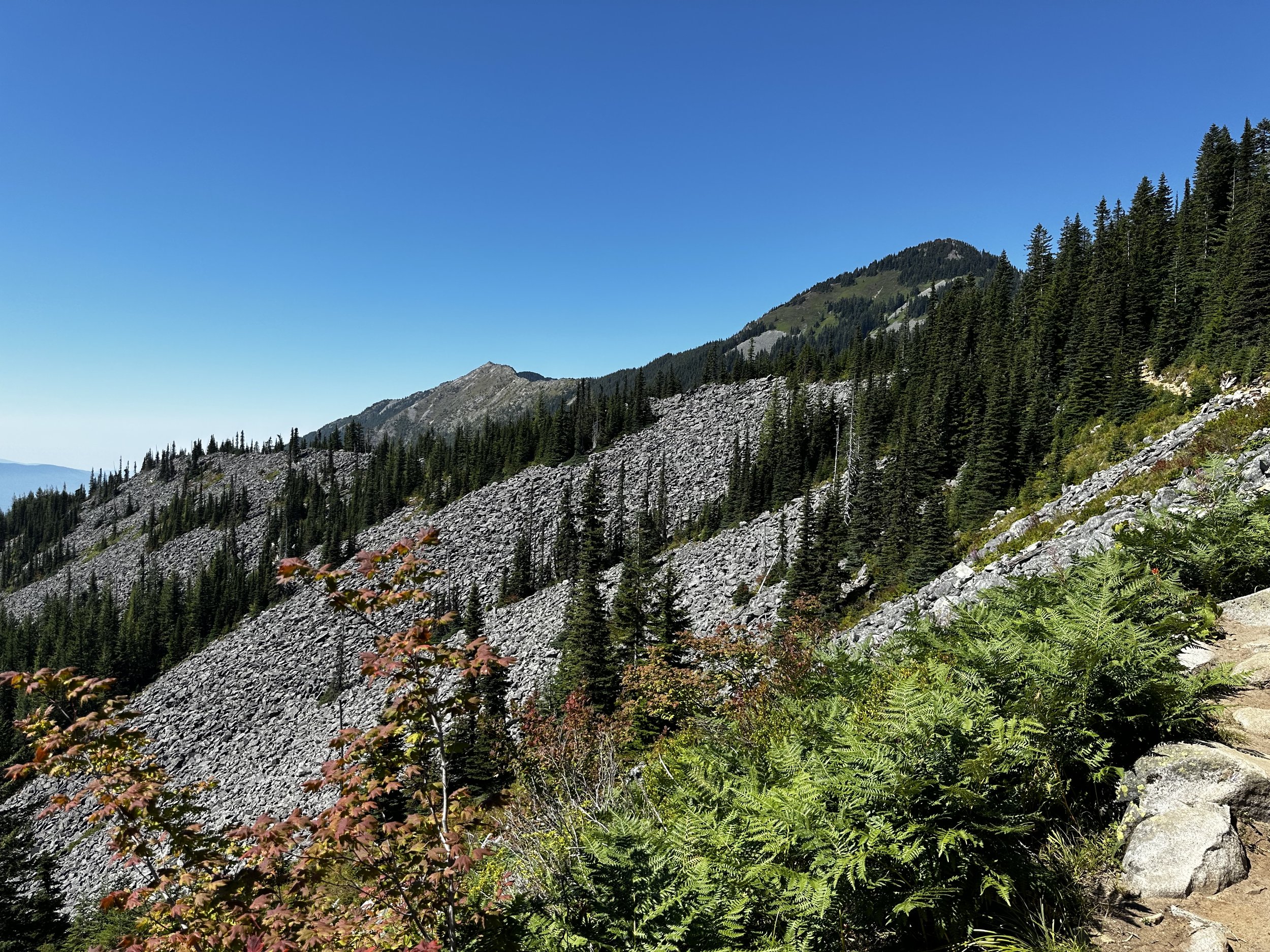
Nearing the steepest of the climbing, the trail begins a series of short switchbacks to ease the pitch; several more old landslides can be seen trailside, now looking like grey streaks of boulderfield along the mountainside. As the steep path begins to crest, it emerges from the dense forest to sidehill near level, westwardly. A myriad of wildflowers add splashes of bright color to the otherwise lush, verdant hillside.

Passing old slides enroute to the summit spur trail
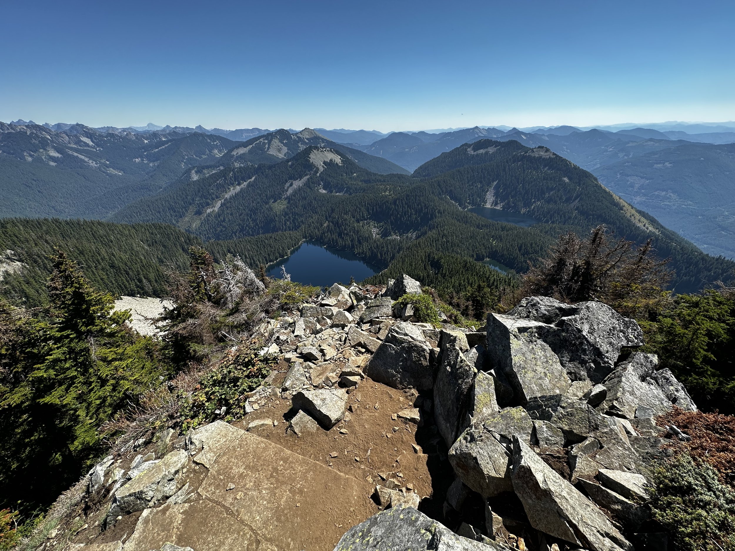
Enroute to the summit spur path, a wide, old landslide is traversed; footing is surprisingly good, appearing graded as one passes across the jumble of boulders. Upon departing the dense canopy, the panoramic view is one of the finest I have ever witnessed: jagged, slide-streaked peaks rise tall all around, Mount Rainier emerges from the earth’s crust to the south as a massive, glacially-streaked, white mound.
An unsigned junction brings hikers to the Mount Defiance Summit Trail, as it is listed on some topographic maps. This brief section of pathway is by far the steepest, and most rugged of the trek: very loose and sandy footing surrounds jagged boulders, which protrude from the mountainside. Zig zagging around vegetation and several angled rocky outcroppings, after a steep, arduous ascent, the trail reaches the ridgecrest, a final trek of several rods brings hikers to the unsigned summit, where views continue to abound.
Eastward views from Mount Defiance
Navigating to the eastern side of the ridgeway, fine views toward the Enchantments and Alpine Lakes Wilderness region can be obtained. More immediately in view, the Pratt (5,099’) and Bandera (5,241’) Mountains encircle the cluster of Mason and Kulla Kulla Lakes (along with their smaller subsidiaries); Island, Blazer, and Rainbow Lakes dot the larger water bodies - all shone a deep blue-green hue amidst the stunning, blue-sky backdrop.
A remote, high-perch summit such as Mount Defiance is a mountaintop where I could remain for a good long spell, observing features and streaks along the harrowingly steep slopes; mountain ranges like bands of saw teeth stack up as they fade into the horizon.

Zoom of Mount Rainier from Mount Defiance
Finding it challenging to tear myself from such a momentous panorama, cautiously I made the trek back downslope atop the sandy surface, angled rocks in the footway provided adequate traction for the precipitous descent back to the main trail. Following the Mount Defiance Trail eastwardly now, I stopped to gawk at the mighty Mount Rainier one final time before dipping back into treeline.

Bandera Mountain (right of center) from Mt Defiance Trail
Back at Mason Lake, time was taken for a quick dip into the alpine lake to cool down from the rapid descent; the overhead sunshine was strong here, at 4,200’. Several other hikers and backpackers dotted the shoreline, all spread apart enough to provide a sense of privacy. Once finished with the cool-off session, we continued descending, opting to follow the well-graded, Ira Spring Trail back to our awaiting car at the trailhead.
Mount Defiance from Ira Spring Trail switchbacks
Initially swinging around the rocky, western shoulder of Mason Lake, before long we were completely exposed, and descending a rocky, sandy series of switchbacks. All throughout the descent, we had stunning views - a 180° panorama, with the mighty, snow-capped Mount Rainier in plain sight. As the day was becoming oppressively hot for hiking in full exposure, we greeted several parties who were still ascending the steep switchbacks, all drenched in sweat and puffing hard to push themselves uphill.
The graded horse path welcomed a bit of haste; into each bermed corner we ran, often letting gravity assist us in a “controlled fall” downslope. Passing several more, smaller waterfalls and drainages, we thought of stopping once again to cool off, but pressed on, knowing a chilled watermelon was waiting back at the trailhead.

One final glimpse before dipping into treeline
Passing again the blocked entrance to the Old Mason Lake Trail, I questioned how one could even recognize the old corridor, but once you know it’s there, the old route is not hard to locate. Back at the trailhead, I immediately began searching for another nearby peak to scale - I craved more of those intoxicating, lofty views. With our GPS set to guide us toward the Enchantment Mountains of central Washington, we would settle for these jagged spires for the coming days of exploration.
Overall stats for the day:
9.48-miles
5hr 9 minutes (+20min alpine lake dip)
3,684’ elevation gain
Mount Defiance - 5,584’