
Mendon + Killington Peaks
A trek to one of Vermont’s highest bushwhacks; I had been putting this mountain climb off for a while, waiting for favorable conditions - would winter prove most efficient woods travel or perhaps in warmer weather when I don’t have to worry as much about exposure or being concerned about crawling through dense spruce cover at a snails pace deep in the cold woods.
Over the course of several years pondering over a route in which to ascend the trailless 3,840’ Mendon Peak, it never occurred to me, until the eve of my planned departure, the option of linking up another Vermont high peak. While there is plenty of information and trail(less) reports of how to ascend Mendon Peak by way of old logging roads and abandoned woods paths, information regarding the nature of the forest between Mendon and Killington Peaks was sparse - I’d have to figure it out in real time.
Old logging road turns herd path
Conveniently, constructing a loop out of these peaks is entirely possible by utilizing the Bucklin Trailhead; located in Brewers Corner, this is the traditional hiker trailhead to ascend the 4,235’ Killington Peak. Beginning the trek at 5:09AM, there was sufficient ambient light to keep my headlamp stowed away while the sun had yet to rise over the surrounding eastern peaks.
Beyond a gate I followed a rugged, old road for 0.5-mile, passing the Catamount Trail before my debilitated old roadbed swung easterly to eventually skirt along the side lawn of a camp; I tried to pass unnoticed as the residence seemed to be occupied yet I saw no Posted signage anywhere along my route.

Sunrising as the trail switchbacks
Knowing that I would need to follow the Eddy Brook closely, I avoided the temptation to follow any side spur paths despite appearing drier than my current trail. At ~1.4-miles, the first crossing of Eddy Brook was made atop slick river rocks; about half-mile after, however, the old logging road re-crossed the brook. Deciding that remaining on the southern edge of the waterway would be safer and prevent repeated wet-rock-hopping, I began bushwhacking while keeping the brook insight all the while.
If the road can be followed, that may prove more efficient - if not more safe, as well. This stretch of bushwhacking rolled along the hillside, through tremendously wet patches, copious amounts of rotten blowdown and hoards of hobblebush which began to form a thick carpet across the forestscape. Numerous overgrown logging roads scattered in various directions while I opted to continue along the brook.

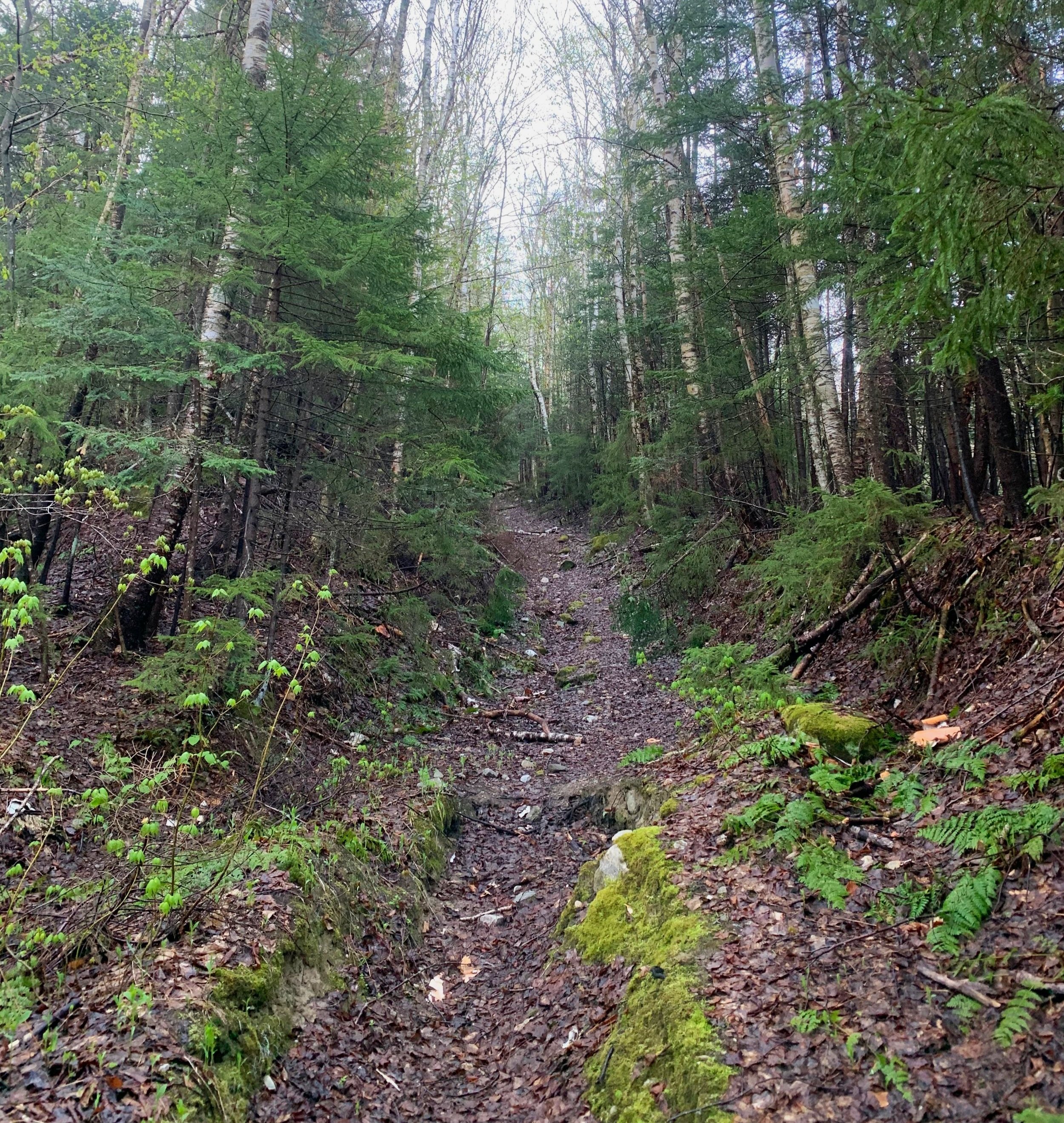
Lush moss carpeted forest bushwhacking
Rejoining the old road at ~2,500’ as it swung over Eddy Brook once again, the herd path began climbing steadily with conifer boughs littering the trailside - evidence of minor trail maintenance from others who had passed by previously. The old woods road was unmistakable - narrow yet well defined; a remarkably soft footway produced by years of fallen leaf litter and rotten duff.
Reaching ~2.9-miles, the “bushwhack” now swings northwest, gaining elevation by a series of well-defined switchbacks; the sun began rising from behind Killington and other peaks off to my east, casting glowing crepuscular rays through the low-hanging morning dew as it rose off the mossy forest floor.
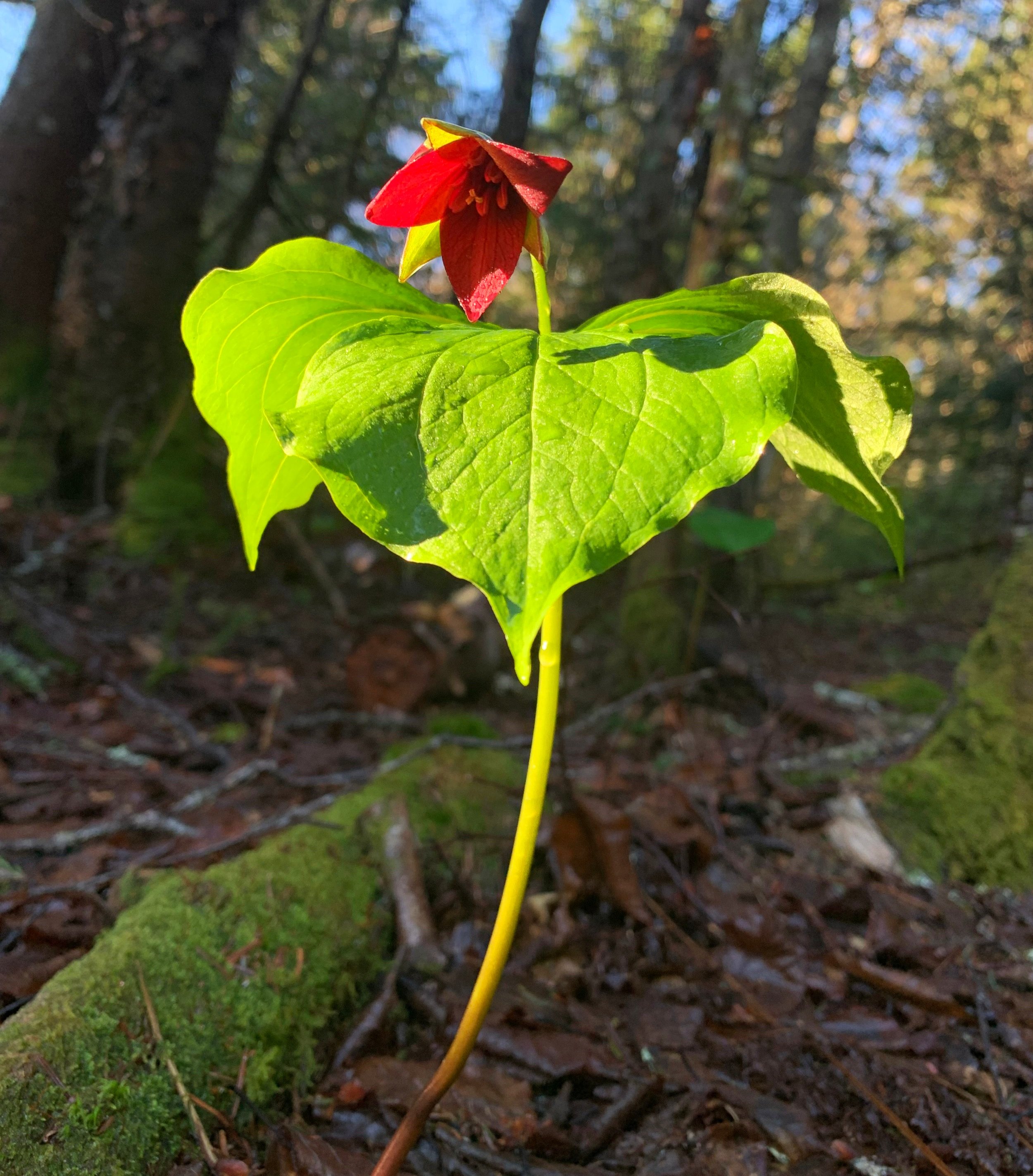
Mid-trail red trillium delights
Nearing the col before the final ascent up Mendon Peak I ran into patches of blowdown forcing me to abandon any inkling of an herd path. Luckily, aside from the blowdown, the conifer cover never became overwhelmingly dense; for just a brief moment I began descending off the far-side of the col, with a quick redirect I was back on track.
Another well-defined herd path helped to meander up the steep hillside, now in a westerly direction. Reaching a short spur path following a minor false summit I found a remarkably picturesque ledgy lookout area with vast panoramic views - the highlight of which cast back toward the east, along the ridge from which I had just ascended and beyond to the towered summit of Killington - where I would be heading momentarily.

Another old corridor cut in a stunning forest
While not wanting to depart my lovely remote perch in the wilderness, I had a summit to attend to; within mere minutes I came upon the canister and quirky, hand-painted sign. What a joy to find a terminus like this at the end of a trailless climb through the Green Mountain wilderness - moments such as these found in the woods, for me, cannot be bought.
While trying to follow my footsteps back down-slope I ended up briefly taking a random herd path while descending the Mendon Peak summit cone, hoping this might skirt along and around the northern slope of the false summit I quickly realized this was descending much too far north. I backtracked to regain my ridge-top herd path toward familiar certainty.
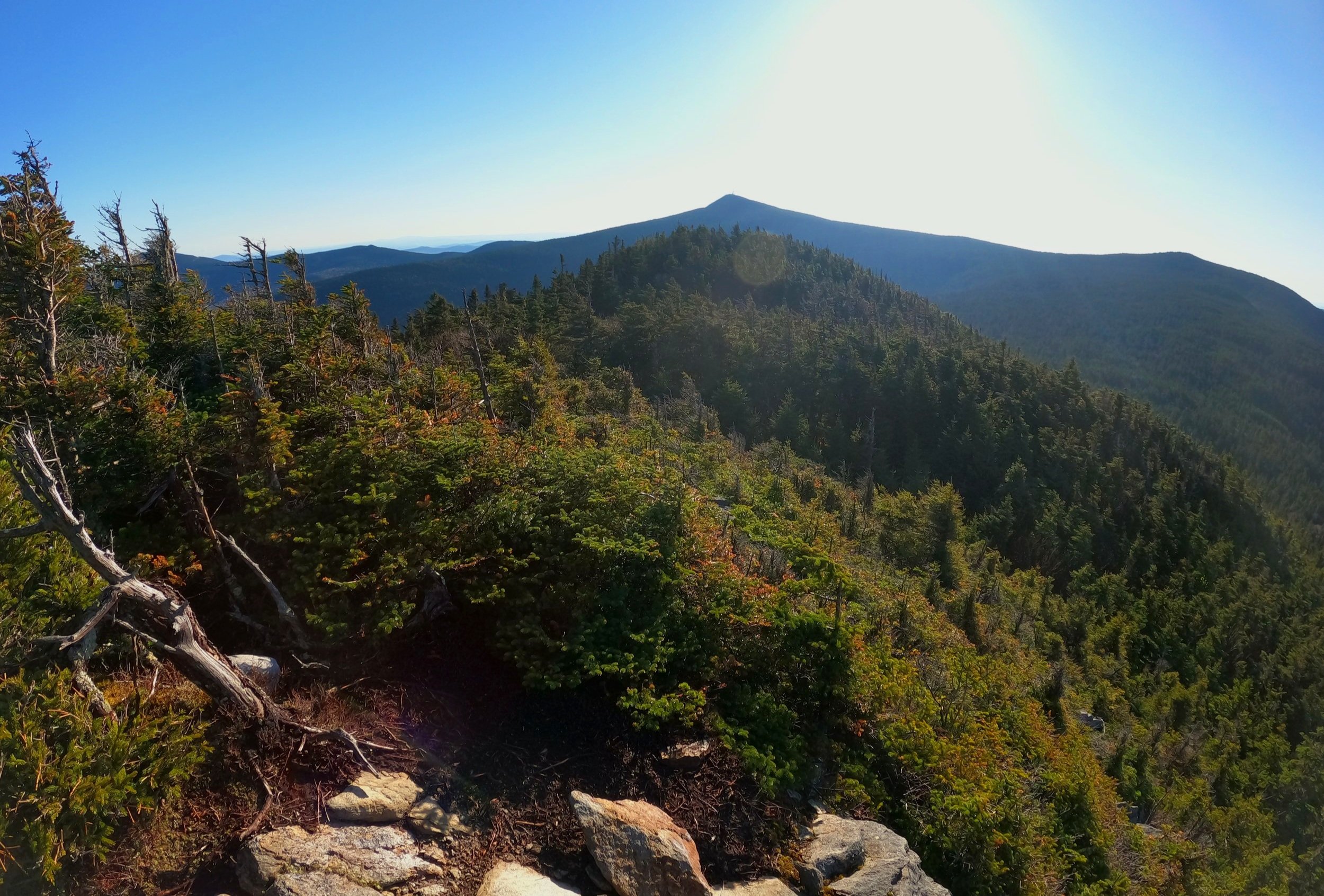
False summit + Killington in the distance
Recalling my wild circular meandering around the swath of blowdown while ascending moments earlier, I clung to the northern edge of the col until returning back to a junction or landing area where an orange emergency sled is stored before diverging yet again into trackless forest.
Initially, I climbed southeasterly up the western ridge of Little Killington until reaching the northeastern col. It would be a task for me to recall a forest as brilliantly green as this - a damp, thick mossy carpet covered all to see while lichen draped from nearby conifers, truly a beautiful stretch of earth that few other trampers had feasted upon.

Mendon Peak summit
Occasional moss-covered blowdown forced me to stray from my bee-line path, directed straight along the Little Killington col, beyond which I would pick up the Long Trail/Appalachian Trail north for the remaining distance to Cooper Lodge.
Not long from now, this stretch of LT/AT would be bustling with thru-hikers heading in either direction, but this morning all was silent on trail, not a single person was encountered during the entire hike - on or off trail.
The white-blazed path cut intimately through the otherwise thick conifer forest atop the graded footway, the late-season snowmelt formed chilly puddles amidst the rocky trail.

Mendon Peak from Killington summit
Surely I expected to awaken someone at the shelter with my bear bell jingling but with no backpackers in the vicinity I began up the steep, rocky 0.1-mile ascent up to the summit of Killington Peak, at 4,235’.
The short spur path has always fascinated me, with its shattered bedrock appearance; as one climbs the jagged rock, conifers become short, scrubby specimens. All along the upper-half, the views begin to open up - my gaze was primarily cast back on Mendon Peak, enjoying the sight from which I had just come.
Still in shock that I had the summit to myself, I roamed briefly to soak in not just the morning sunshine but stunning views as well. With a careful descent down crumbling mountainside I was back at the shelter and ready to continue onward, toward the Bucklin Trail which would guide me back to the trailhead where my car and salad awaited.

Descending Killington Peak
After a short 0.1-mile stretch the Appalachian Trail diverges to the right while the Bucklin Trail veers left. The trail looses elevation rapidly while the higher-elevation conifer canopy transitions to one of hardwoods, ferns and a thicker, greener leafy understory.
The Bucklin Trail begins following the southern edge of Brewers Brook by way of old woods roads which I’ve found to be often soggy in places. If time allows, a short side spur path down to Irene Falls is well worth the several minute diversion; unless in a period of dry weather, there is a narrow falls straight ahead with a wider, more photogenic falls shortly back up-stream, which is visible from the short path.

Falls on Brewers Brook
By way of wooden bridge, the path crosses to trace now the northern edge of Brewers Brook for the remainder of the trek. Meandering along, the Bucklin Trail veers slightly right onto a re-route section of drier land, rolling through a lovely hardwood forest.
Just after crossing the brook for the final time, hikers are greeted with a small information kiosk before making a 0.1-mile trek back to the trailhead parking lot.
While it is certainly enjoyable to hike an out-and-back, with Mendon Peak as the destination, given the proximity to pathways such as the LT/AT and Bucklin Trail - if you’re already on a bushwhacking kick, why not continue the short distance through a lovely stretch of mossy conifer forest and add in a 4000-footer featuring more incredible vistas, a shelter for a tea break and even a waterfall once off the steeper slopes of Killington Peak.
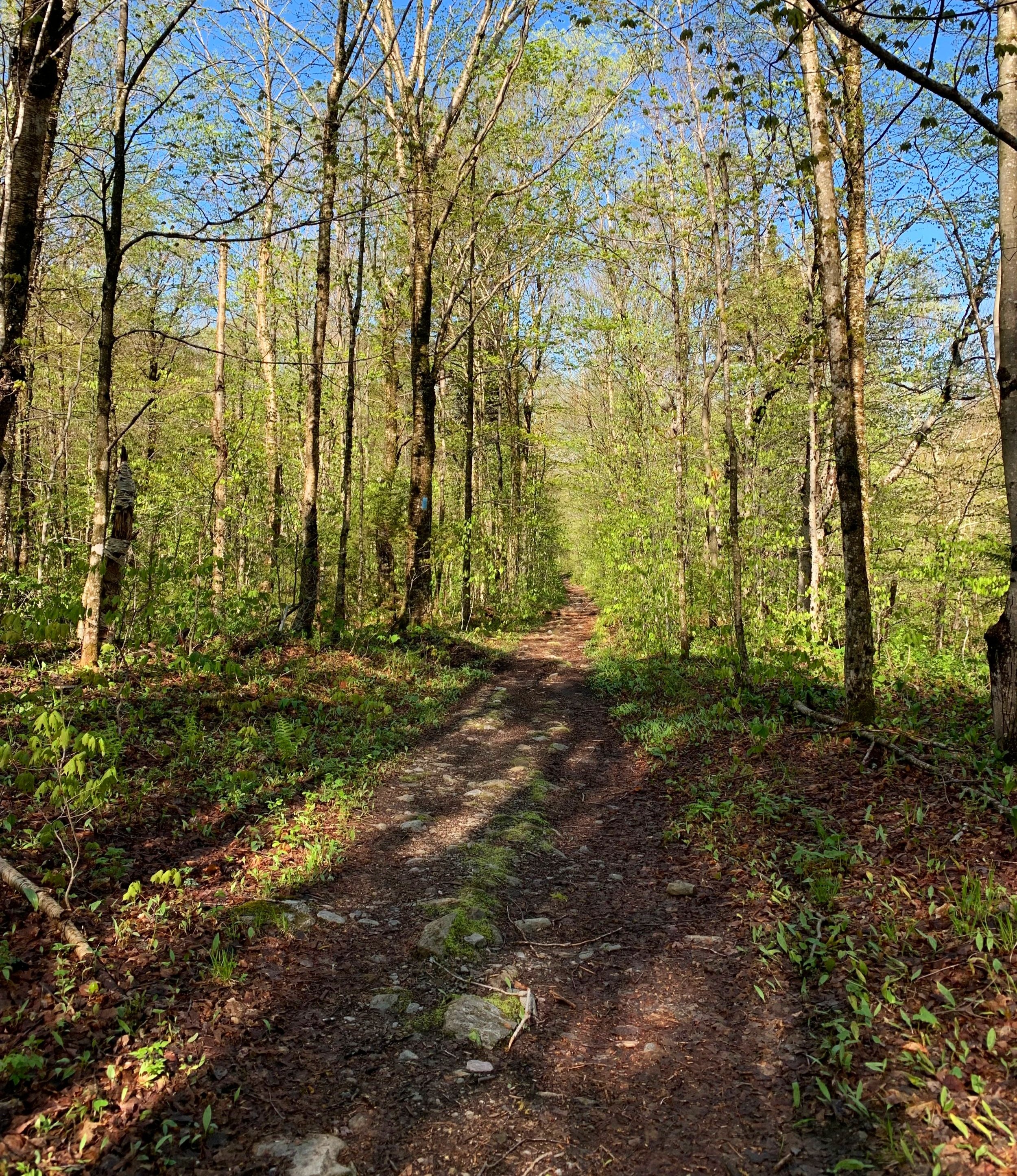
Lower Bucklin Trail
This area of the Green Mountain National Forest stands in complete contrast to the eastern side of the mountains, which are streaked with proliferating ski trails; this forest beckons the hiker to slow down and breathe in deeply, to pause upon its ledges and just be still momentarily - life will always be waiting for you on the other side of the trailhead.
Overall stats for the day:
10.79-miles
4hr 16 minutes
3,389’ elevation gain