
Mount Mansfield
An ascent through an iconic Civilian Conservation Corps-built state park, strolling along historic moss-carpeted forest roads before culminating with a dizzyingly steep scramble up precipitous schistic slabs or perhaps a ramble along a beautiful Green Mountain Club-crafted pathway which winds uphill through a stunning hardwood forest, eventually leading to scrappy coniferous krummholz before finally opening up to a bare summit ridge dotted with dinner plates of diapenzia. I cannot make the arduous decision for which wins most scenic or favorable - my adoration for both sides of the 4,393’ mountain is at a draw.
- Western Approach -
Departing northeast out of Underhill Center, Mountain Road winds its way up the western flank of Mount Mansfield before reaching the Underhill State Park at 1,830’. A modest $5 day fee gains access to the restroom and washhouse facilities near the Park Office; the trailhead begins at the eastern end of Mountain Road.
Beginning at 6:30am along the Eagles Cut Trail, for the initial 0.3-miles the old Civilian Conservation Corps (CCC) road zig-zags back and forth before eventually the two paths merge into one old forest road. Turning right at the hiker kiosk and Laura Cowles Trail junction at 0.7-miles, a nice loop is made by first trekking south along the old CCC forest road; not far down this old road I encountered my first ruffed grouse as it stealthily awaited an unwitting hikers arrival before accosting everything in sight, at which point the terrestrial beast flew a mere 15’ down the forest road before repeating the extravagant stunt several times.

Ascending the Maple Ridge Trail
This road, along with so many others across the United States, were constructed generally between 1933 and 1948 by the CCC. Their tasks primarily consisted of various forestry projects which delt with harvesting, disease management and fire control (fire towers, cabins, telephone line extensions) as well as planning and construction of recreation facilities such as camping, picnic, beach and ski areas - most of which featured CCC-built trails and roads, much like the old stone pathway I now found myself traversing.
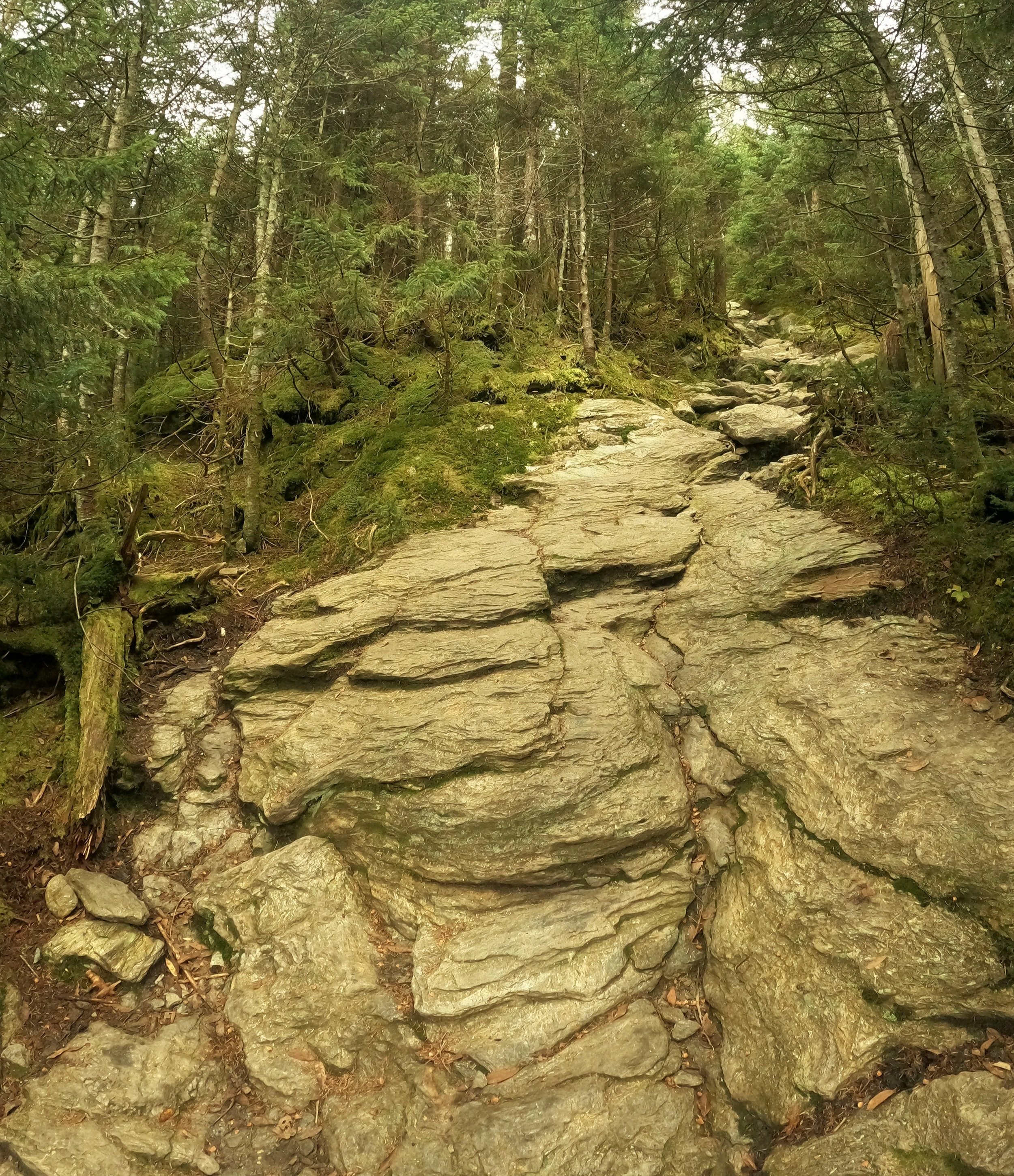
Before long the wide road bed became wet underfoot with lush, green understory grasses and moss-covered boulders and fallen logs trailside. The trail nearly followed the 2,600’ contour along Mt Mansfield’s western slope before hitting the steep mountainside head on and beginning up Maple Ridge.

Southerly views + a mountainside boulder
Departing the old road, the trail gains nearly 1,350’ in its 1.1-miles to reach the open summit of The Forehead. A pathway along Maple Ridge was originally blazed in 1856 and then “restored” nearly a century later. Today, the Maple Ridge Trail begins steep and does not let up until reaching the ridgecrest. Initially atop wet and heavily eroded rock slabs while under the shade of the forest canopy, some steeper grades offer hikers drilled divots cut in the bedrock for foot placement while ascending the vertiginous slope. Over-the-shoulder views toward the Adirondacks in the west and even glimpses of the rocky precipices northward, toward The Chin, begin to appear as conifer growth becomes increasingly short and scrappy with climbing. Many steep, rocky scrambles and a quick leap from ledge to ledge is made while enroute to the first 3,900’ peak.
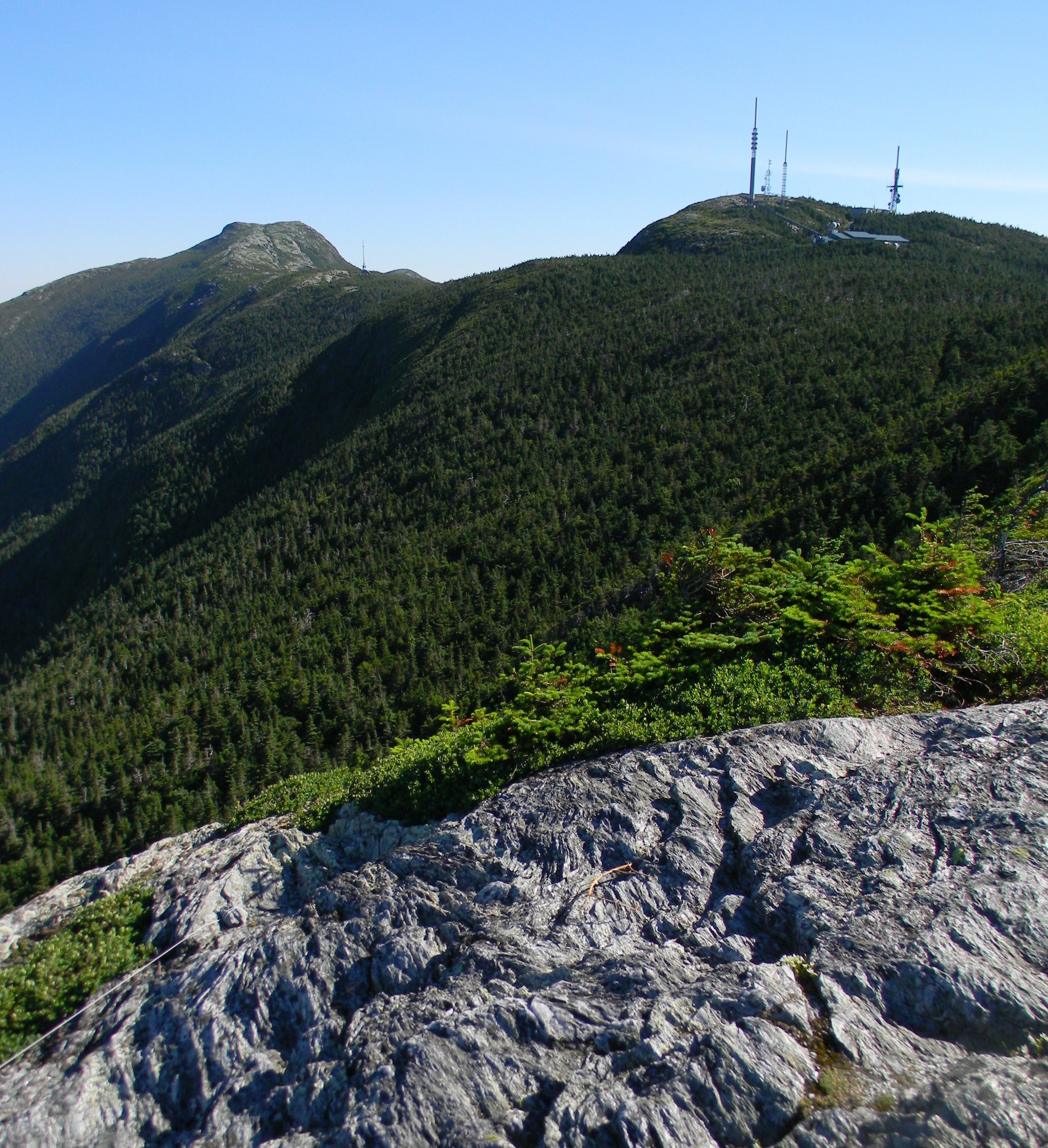
The Chin + The Nose
Once the treeline is surpassed a rocky area is reached which is the resting place of several moderate-sized glacially-dropped erratics; nearby, bluets, sandwort and diapenzia produce petite flowers while Bigelow’s sedge waves gently in the mountainous breeze. What remains for conifer growth is now bushy, twisted and hardened by years of exposure - harsh, artic winds of the high altitude environment. The fine knit of krummholz roots work relentlessly to hold the remaining soil in place.
Even blueberries can often be found amongst the alpine tundra atop the Mount Mansfield ridgeline; many plant species are encountered which take a tremendously long stretch of time to grow and are only found atop the highest summits of the northeast. While minor alpine regions can be found elsewhere above 4000-feet, Mounts Marcy, Mansfield, Lafayette, Washington and Katahdin all preserve the majority of 13-square miles of remaining flora and fauna to be found in the true northeast alpine.
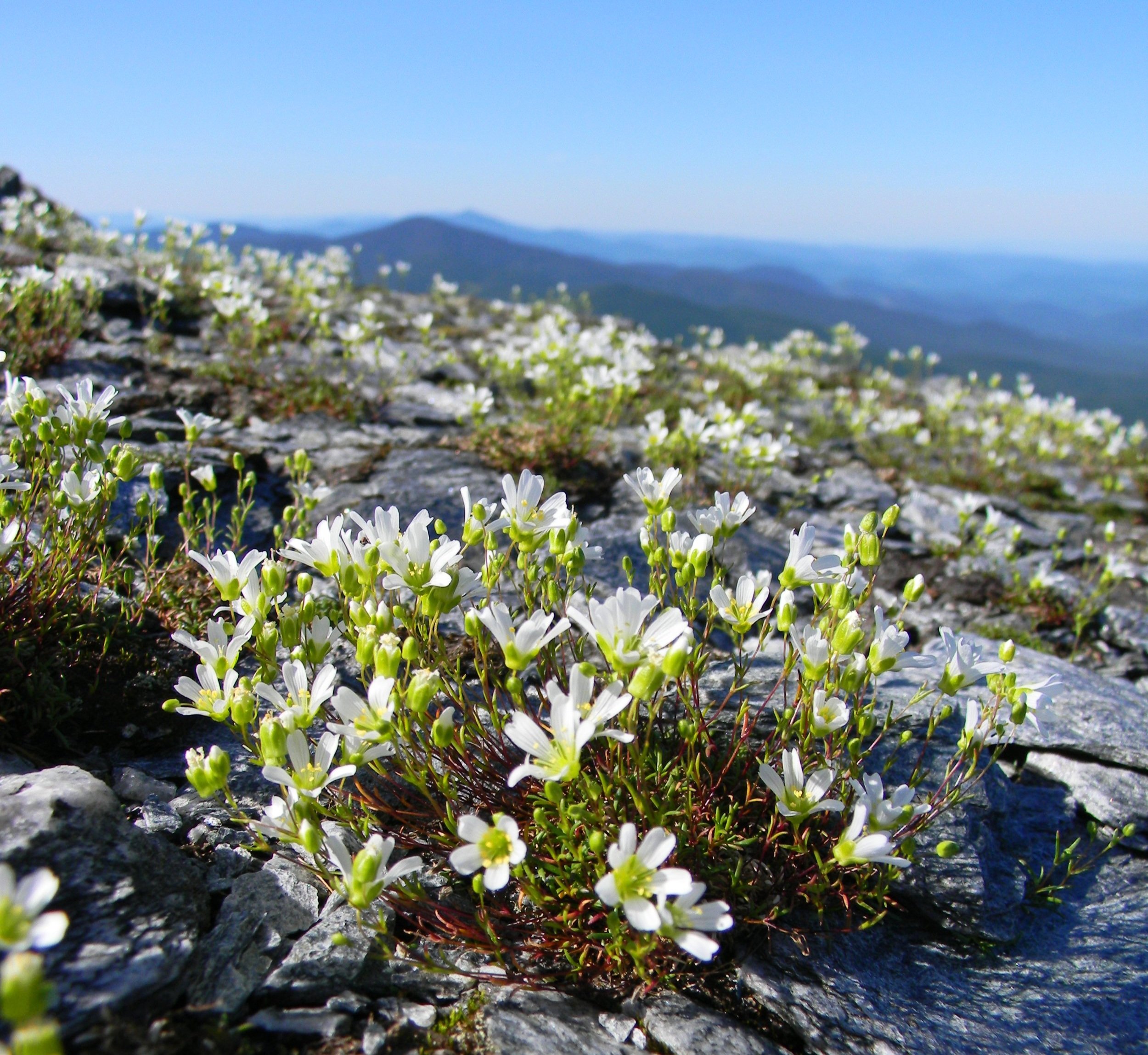
Alpine sandwort nearing 3,900’
Descending back into tree cover, the path now becomes a part of the 272-mile Long Trail; completed in 1931, the path stretches north to south across the entire state of Vermont. The white-blazed Long Trail emerges from dense forest along the radio tower access road, which becomes the Toll Road further down the eastern side of the mountain. Following along the Long Trail, the narrow path winds through scrappy spruce and fir atop stretches of boardwalk before opening back up to bare rock along the ridge.
Green Mountain Club’s signage and carefully placed, trailside white-cordage reminds hikers to remain on the designated trail and bare rock to preserve the fragile mountaintop ecosystem. Rolling along the ridgeline, enroute to the highest summit, several mountain bogs are passed which affords glimpses at even more rare plant varieties.

The Forehead summit
For 1.7-miles the trail traverses the ridgetop before finally ascending to 4,393’, the highest point in the state of Vermont: Mount Mansfield. All around the bare summit, places to stop for a snack and to bask in the ceaseless views can be found - the summit of The Chin has the best easterly views, downward toward Stowe and boundlessly onward across Vermont, many high peaks of the White Mountains can even be appreciated from the summit ledges.
Descending and swinging southeasterly, around a large band of craggy rocks, brings hikers to the Laura Cowles Trail and henceforth the Sunset Ridge Trail. This popular route was originally cut by Clarence Cowles, the gentleman who personally cut the original Long Trail from Mount Mansfield to Camels Hump (today, lays 25-miles apart), who simply desired a more direct route from his home in Burlington, VT.

South from the summit of Mount Mansfield (The Chin)
A stunning panoramic view westward accompanies the steep, slabby descent off the west-facing ridge. Footing becomes increasingly loose as one descends and plummets back into the forest canopy nearing ~3,300’, the pathway showing years of wear from heavy foot traffic; log staircases and wooden waterbars aid in erosion control as the trail becomes increasingly rocky.
While the Sunset Ridge Trail is never nearly as steep as the Maple Ridge Trail, which was ascended upon, I would enjoy a winter ascent along this ridge, however, Underhill State Park is closed (assuming the gate is locked as well) from October until Memorial Day each year, which would prove to become a logistical nightmare in which to gain access to its trails.

Departing along the Sunset Ridge Trail
Following a series of switchbacks down the Sunset Ridge Trail, several small brooks are bridged as the old CCC forest road of earlier this morning is soon reached and followed back to the hiker parking lot and camping area; thus wrapping up a highly rewarding hike with stunning views in all directions, steep scrambles and lots of quality trail to roam - and a very cacophonous run-in with my first ruffed grouse in the wild.
Overall stats for the day:
8.1-miles
3hr 56 minutes
2,887’ elevation gain
- Eastern ascent -
Having also hiked the eastern approach of Mount Mansfield in winter conditions, I recalled a significant hardwood presence on the lower slopes of the mountain - thus encouraging an early morning, fall foliage ascent. While not truly peak foliage per se, the luminous yellows, oranges, lingering reds, and array of umber hues all provided an intoxicating warmth to the mountainous canopy unlike any I had hitherto trekked through.
Utilizing the Long Trail for the ascent up the mountain, I parked at the Stowe Ski Resort which had copious amounts of available parking as it was then autumn. Thankfully, the resort also did not appear to be charging a parking fee to patronize their lot in the warmer months.

Ascending the glowing Long Trail south
A quick 0.3-mile roadside warm-up brings hikers to the Smugglers Notch crossing for the Long Trail; the pathway on the east proceeds northerly toward Canada, while the white-blazed Long Trail on the west side of Route 108 will guide hikers eventually the Massachussets’s border, with my objective along the route: Mount Mansfield.
Departing the road along the Long Trail south, the trail switchbacks up the mountainside in the trench of a well-worn footway, initially tracking just northeast of a tributary to the West Branch Little River to the east. Soon ascending by both stone and log staircases, the footpath quickly becomes rockier underfoot as it climbs ~760’ in the initial 0.75-miles prior to crossing the drainage.
Ascending a slabby sidewalk, ~3,300’
Climbing higher, the Long Trail begins to reward with fine northeasterly views back over the shoulder and beyond the tree tops; the trail soon becomes increasingly rugged, a bare rock slab sidewalk comprises much of the final ascent up to the Taft Lodge at 3,630’. Originally constructed in 1920, this cabin has undergone several restorations throughout its life along the western flank of Vermont’s highest, the most recent of which being in 2016.
Following the Long Trail south toward The Chin, a narrow trail corridor cuts through scrappy evergreen and eventually opens up, displaying a stunning glimpse of the rugged and seemingly untraversably steep crags of Mount Mansfield’s western summit wall. The trail proceeds northwesterly, diverting around these cliffs and entering the Chin-Adam’s Apple col at 4,020’.

Clouds above and clouds below; from the Adam’s Apple
A short out-and-back to stand atop the Adam’s Apple is highly recommended; the views from atop this 4,120’ sub-peak more than reward for the additional energy spent during the quick ascent. Looking south along the chain of rocky summits which comprise the Mount Mansfield ridgeline is very unique and should not be overlooked.
The final ascent up The Chin of Mount Mansfield is by far the steepest yet, and a source of great bottle-necking along the busy trail. One short pitch requiring the use of well-placed feet and handholds in which to hoist oneself up the mountainside chute appears intimidating but the rock is stable and consists of very coarse aggregate; however, I would much prefer to ascend than descend this narrow chimney of rock.

Clouds overtaking the Adam’s Apple from The Chin
The grade decreases dramatically despite continuing to scramble along bare rock toward the summit cone. Glancing down at the schist underfoot displays waves and folds captured in the once plastic and flowing bedrock, flecks of mica and quartz speckle the otherwise dull-grey slab.
Many trails convene at the summit of Mount Mansfield, making for a Times Square of summit resting areas; a small, golden survey bench mark disc can be located near the high point. Following along the summit ridge, white cordage denotes the intended path and works to keep traffic atop fragile alpine plants to a minimum.

Undercast atop Stowe
The standard 2x6” white blaze of the Long Trail (and conveniently the Appalachian Trail) indicate the path along the ridge crest as short, scrappy conifers and high altitude bogs can be found trailside. A plethora of side trails diverge as one traverses the summit, before departing the ridge I took a quick trek up to visit The Nose at 4,064’.

The Chin from The Nose (looking north)
The climb up this sub-peak is mostly accomplished by way of gravel access road, several radio towers and outbuildings are passed enroute. Nearing the end of the roadway I departed onto bare rock which would guide me by way of “bushwhacking” up the open summit for another unique glimpse northward toward Mount Mansfield, a shattered US Coastal Survey benchmark disc remains partially embedded, appearing as if a greedy visitor had tried to relinquish it from its robust concrete base.
While completely unexpected, a soft, moss-lined pathway awaited along the Forehead Bypass and South Link trails; through a dense forest of mature balsam fir, aging ferns and moss, the paths veered easterly, eventually emerging from the lush forest along the Toll Road.

Descending the Forehead Bypass
Continuing on a northeastward trajectory downslope, the Haselton Trail coincides with the Upper Nose Dive ski trail for the initial 0.2-miles before diverging over a low stone embankment and into the sweeping forest. For it being one of the oldest trails on Mount Mansfield, it certainly demonstrates a wealth of judicious trail building and craftsmanship. Atop several stone staircases the path modestly looses elevation as it bisects an access road (Lower Cliff Trail) and begins following along a small babbling brook for a short distance.
The most memorable instance of this trail, for me, is tramping along the well-pronounced ridgecrest which one finds along the lower portion of the Haselton Trail. Even through a dense, mixed understory of both hard and soft woods, the hillside visually slopes away from the narrow path on either side. On this autumnal hike, fallen leaves and dry conifer needles lay mid-trail, creating a radiating glow from both the tree canopy above and the treadway below, as the low sun shone through.
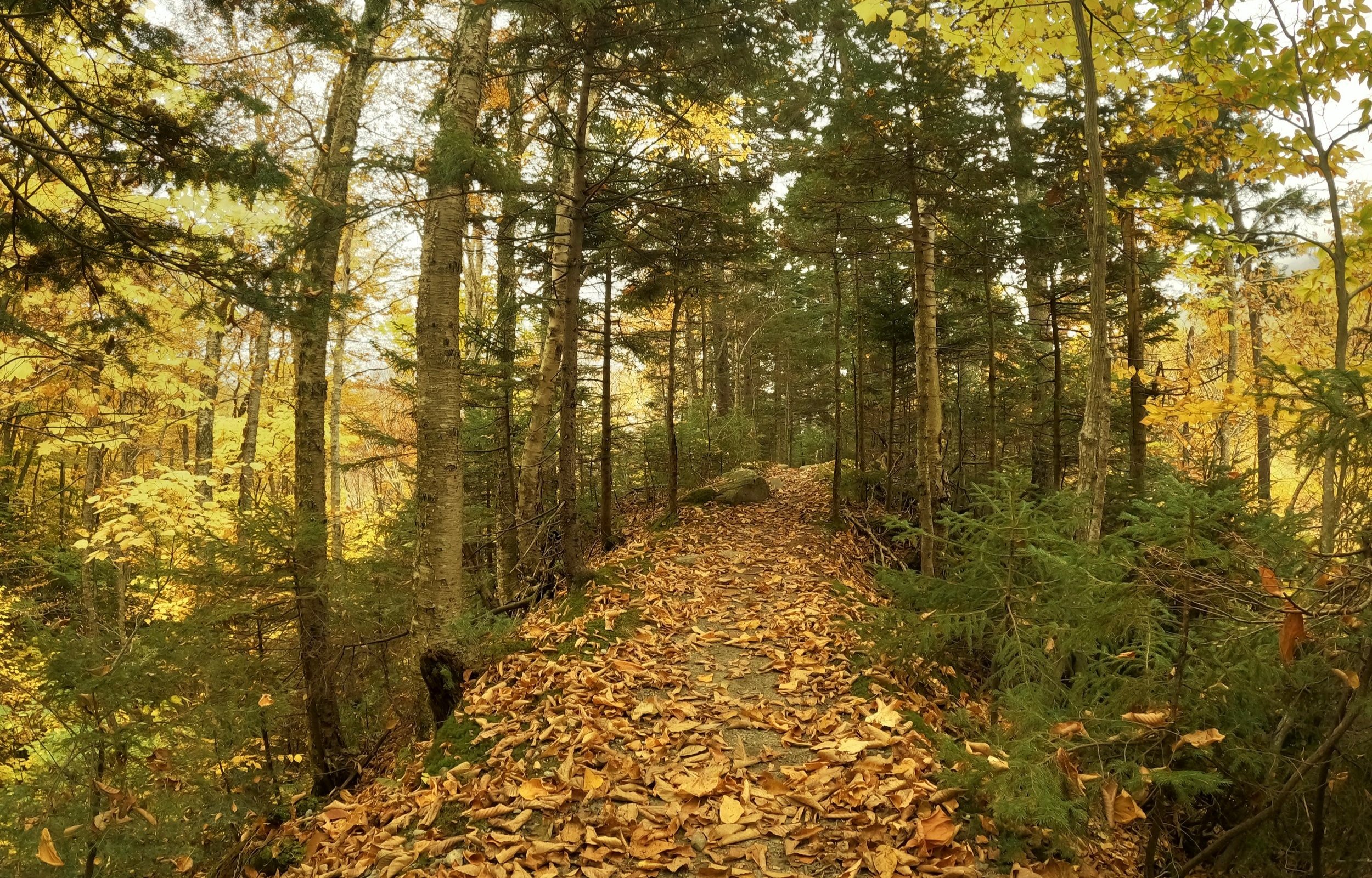
Lower Haselton Trail
A true sense of accomplishment overcomes oneself as the trail terminates at the base of the ski resort; scurrying all around are visitors who also came to glimpse the vibrant foliage. The gondola squeaks and hums as it whisks non-hikers up the mountainside to capture their coveted snapshots of the fiery hillscape.
Overall stats for the day:
7.67-miles
2hr 59 minutes
3,297’ elevation gain