
Island Line (Rail)Trail
A cycling friend once showed me photographs of a narrow, crushed-stone path, either side adorned with refrigerator-sized blocks of brilliant white marble; a trailway seemingly floating atop a dark blue Lake Champlain which mirrored an equally blue sky overhead. He knew of my passion for running moss-carpeted mountain trails and suggested I look into this path, if ever in Burlington, VT.
Several times I tried to make the drive from the White Mountains of New Hampshire to western Vermont but always seemed to get sidetracked with the higher peaks of the Adirondacks just beyond.
It’s been a few years since running distance competitively (50K’s and timed endurance events mostly); now, long days were spent in the mountains with some local rail trail jaunts sprinkled in for mileage on muddy spring days.
While still rehabbing a pesky knee injury from early summer 2022, I figured this was finally the right time to see what the Island Line Rail Trail had to offer - end-to-end.

Island Line Trail
In its former life, the rail line - now bike and foot path - was owned and operated by the Rutland Railroad, opening the stretch of mixed freight and passenger line in 1899 from Burlington to Rutland. Unfortunately for the railroad (fortunate for foot-travelers!), the final train passed through September, 1961, following several rounds of strikes.
My journey began at the southern terminus of the path - at Oakledge Park where a spacious parking lot is found. The restrooms were closed for nearby construction but several porta-potties were available near the main entrance.
The initial 7-miles of the rail trail is paved and is maintained by the city of Burlington as the Burlington Bike Path. Fortunately, for the entirety of the path out to the causeway I was able to jog along on the edge of the path as needed, which consisted of finely crushed gravel - a much softer surface for the bones and joints than asphalt the whole way!
Immediately, the path began following the Burlington waterfront along Blanchard Beach but took a quick detour down several residential side roads, thankfully these were not busy roads and did provide sidewalks to avoid running down the middle of the road.
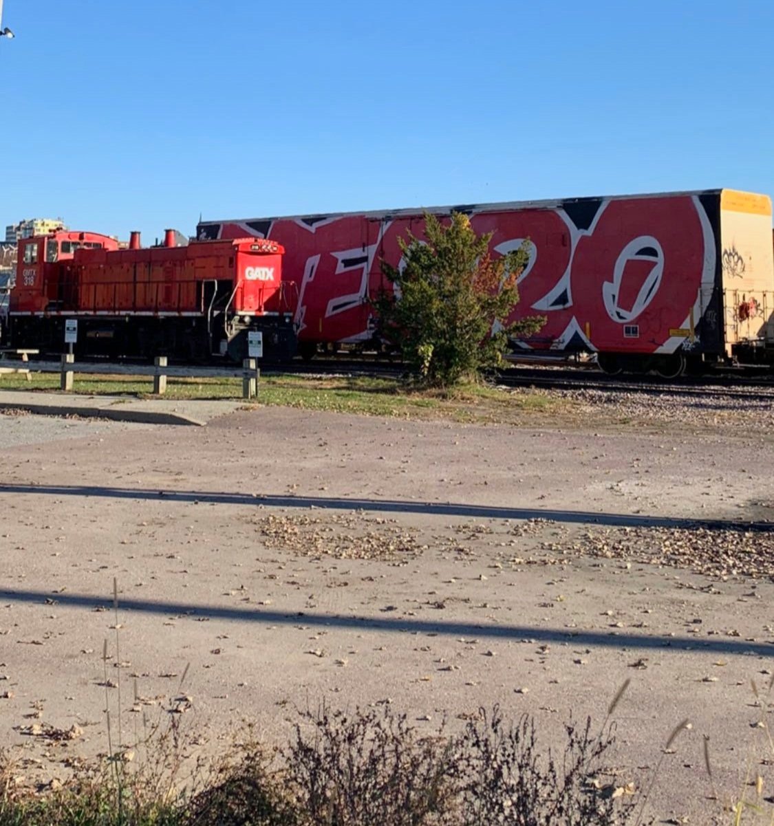
Vermont Railway; Burlington Yard
Swinging left off Harrison Avenue the path traces a tight corridor along an active Vermont Railway yard (chain-link fence separates the active line from retired rail trail) on the right and several backyards and various businesses on the left.
Roundhouse Park and Perkins Pier Parks of the Burlington Greenway is passed, both making good resting places as needed, several interesting sculptures abound with a picturesque Lake Champlain backdrop just beyond.
The trail becomes somewhat obscure as one makes their way through the downtown setting but several cues and paint on the ground help guide the way.

Amtrak’s Ethan Allen Express boards for NYC
At Burlington Union Station, the morning Amtrak train was taking on passengers for the Ethan Allen Express, a commute from Burlington, VT to Penn Station in New York City, NY.
Passing Waterfront Park I stayed on the Island Line path, passing beneath rows of beautiful trees and shrubs while on the return trek venturing down the boardwalk side, nearing the waters edge on a concrete sidewalk - this was interesting to run in minimalist sandals.
Quite a few other recreationists were out on the path as well this early Thursday morning, a mother rooted on her nervous son as he took on the big concrete ramps at the newer Andy A-Dog Williams Skatepark - just beyond must have been the old, retired skatepark which was coated in a fine layer of spray paint and now housed dozens of dilapidated tents. Actually, both sides of the path contained a tent-city for the local homeless.
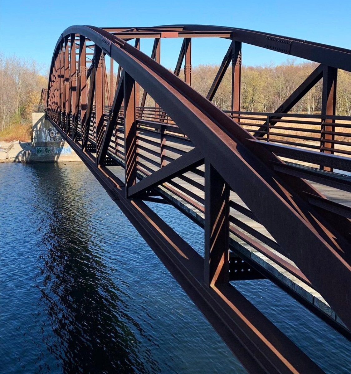
Winooski River bridge
Looking at my running stats, it’s no surprise to me that this was the fastest mile of the day.
Luckily the cleanliness improved and I soon did not find myself needing to keep peering over my shoulder constantly; the path tightened in through a rocky cut, dipping beneath an overpass which contained an interesting abstract art piece of seemingly everyday items superglued to the concrete abutments. All along this stretch of trail, breaks can be taken at any of the mini-parks which contain work-out and stretching instructions.
Nearing 4.0-miles into the trail, private residences are reached which increased traffic a bit, however, everyone I met on any section of the Island Line Trail was very polite and courteous, some eager to strike up a conversation while others simply offered a greeting and continued silently amidst the autumnal forest.

Soft paths on the Island Line
At 6.8-miles the path crosses the Winooski River along a beautiful 600’ arcing bridge which was erected in 2004 to replace a weather-dependent ferry service; also at this time, the stretch of trail which bisects Delta Park was raised several feet above the boggy surface of surrounding land; quite a feat and such a marvelous sight on either side of trail. Here, I certainly felt miles away from the downtown Burlington section of earlier that morning.
The Delta Park trailhead is passed on the left as the trail eases onto residential streets once again, becoming the Colchester Bike Path & Causeway. With an occasional sidewalk the trail now travels along parked cars for the duration of Windemere Way and Biscayne Heights. Cutting across Colchester Point Road the trail becomes railroad bed and unmistakable once again.
For as long as the eye can see the trail remains a straight cut, right through Colchester Bog Natural Area for 0.7-miles until crossing Mills Point Road, where the most northerly trailhead (on this side of Lake Champlain) can be found. From here its a short 0.5-mile trek through Porter Natural Area where one finally reaches Causeway Park - end of land!

Whiteface Mountain in the Adirondacks
The remaining 2.7-miles cut right across Lake Champlain, passing several islands along the way. To the west, the Adirondacks rise tall - the most obvious being Whiteface Mountain at 4,865’ - which boasts the “greatest vertical east of the Rockies”.
Trekking westerly, away from Vermont, Mount Mansfield (4,393’) and Camel’s Hump (4,078’) with many other VT peaks rise high, tracing the northern Long Trail skyline.
As this final section of causeway, overseen by the Vermont Department of Fish & Wildlife, is ultimately exposed to everything nature throws at it, the trail did close several times to receive much needed repairs; once in 2012 and again more recently from 2019-2020, the rail trail received a $1.8-million rebuild consisting of various sized rocks and boulders to deflect high winds and waves as well as a fresh surface of crushed stone.
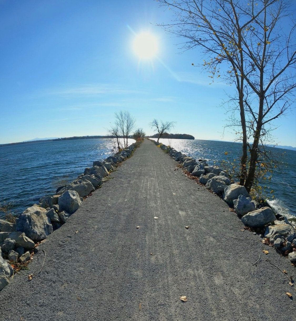
Cutting through Lake Champlain
The views are so immensely vast once out on the Causeway path, its easy to see cyclists speeding up yet remote enough for its users to spread out. Over winter 2023 I even spent some time idle, just listening to the ice popping and crackling on a sunny day, surely reassuring to look down and see solid stone beneath my feet.
Reaching the end of the line, there is a 200’ break in the trail which allows small boats to come and go. Local Motion offers a donation-based ferry to bring bike and foot-traffic to the South Hero, VT side of the Island Line, where they can continue along exploring beautiful countryside or stop in at any of the farms, orchards, wineries or deli’s on the island before returning back south - unless they spot a car and traverse the rail trail in one direction only.
I, however, did not have anyone to spot cars with today, so I took a pause at the end of the path, as the ferry was done operating for the season, before continuing on my way, retracing my steps in a casual stride, stopping to check out the old rail car wheel set which lays just off trail.

Causeway in winter
Beginning my northerly run at 9:30am, the trail was becoming lively with walkers tracing either side while cyclists occupied the center lane. I always like to believe that, wherever I find myself, whether ascending a steep precipice or on a moss-carpeted old spruce forest in the mountains, I can always find a reason to be appreciative of the abounding beauty - finding myself on the right path at just the right time.
Today was no different, albeit a mix of asphalt and gravel path, it was stunningly beautiful (for the most part); certainly an exceptional way to see a side of busy Burlington which cannot be viewed by the car window. The Island Line Trail was full of the unexpected - early morning railroads, trail-side artwork, architecture, bogs, forests, beaches and many, many places to find quiet and solitude - just what we all need a little more of in our days.
Overall stats for the day:
23.9-miles (out & back)
4hr 42 minutes