
Goose Eye via Carlo Col
There is nothing much more pleasing than a sunny stroll through a 3,670’ high-alpine meadow; tall grasses softly rippling in the unobstructed southeasterly wind, butterflies lob lazily from blossom to blossom; today, only yourself and a handful of Appalachian Trail thru-hikers roam the paths which transition near-instantaneously from one of soft, deeply rich soil bordered by a brilliantly green, mossy carpet to stacked and jumbled boulders - hands often necessary for safe passage.
We are in Mahoosuc territory.
Finding the entrance to Success Pond Road took several back and forth passes; the sun had yet to rise as I hoped to get an early jump on the trek up to Goose Eye Mountain. I’d be making a loop out of the journey, visiting Mount Success (3,565’) along the way as it was on the 52 With A View list (if lucky the morning clouds would burn off) and could be reached with a quick out-and-back spur. Then I’d follow the Appalachian Trail, or Mahoosuc Range Trail to crest over Mount Carlo (3,565’) while enroute to the primary objective of my hike - Goose Eye Mountain, thus descending by way of its namesake trail.
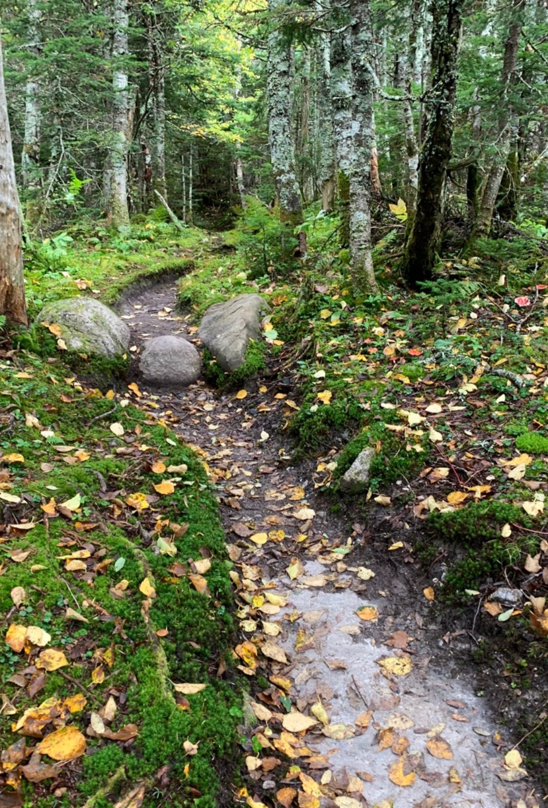
Soft paths of the Mahoosucs
Once I had located the proper entrance to Success Pond Road, off of Hutchins Street (look for the sign indicating: OHRV Parking: 1 Mile), it was fairly easy to navigate the diffuse network of old logging roads. With fear for slashing a tire sidewall, I crept slowly and carefully down the initial mile, beyond which the larger rocks become somewhat scarce and easier to navigate around.
At 5.4-miles down Success Pond Road, the Success Trail parking lot is reached, which is really nothing more than a pull-off accommodating perhaps three vehicles, as the roadway is now blocked by a massive boulder - perhaps so drivers don’t attempt to drive over the failing drainage culvert just off the main road.

52 With(out) a View: Mount Success summit
AMC signs are passed shortly down the pathway, which is initially an old gravel logging road. Grown-in logging clearings are passed as well; this morning, there was a steaming-fresh pile of moose dung mid-trail as I passed - the forest was certainly alive and bustling with activity in the cool autumn air. From the clearings, the 1915-cut Success Trail veers right and begins into the forest.
Up to this point, the trail has gently meandered along an old forest road, heading generally in a northeasterly direction; at 0.8-miles, the path makes a southeasterly swing to join and begin ascending the long, west-facing ridgeline-shoulder of Mount Success.
Footing becomes rough and loose as one climbs higher up the mountainside; at 1.5-miles from the trailhead a side-spur loop trail is reached which guides hikers to a reportedly beautiful lookout - aptly named, The Outlook. From the ledges at ~3,000’, views toward the Presidentials can be had. I did not venture down this side path as I was clearly still in a low-hanging morning fog at 2,900’ - I simply continued on toward Mt Success.
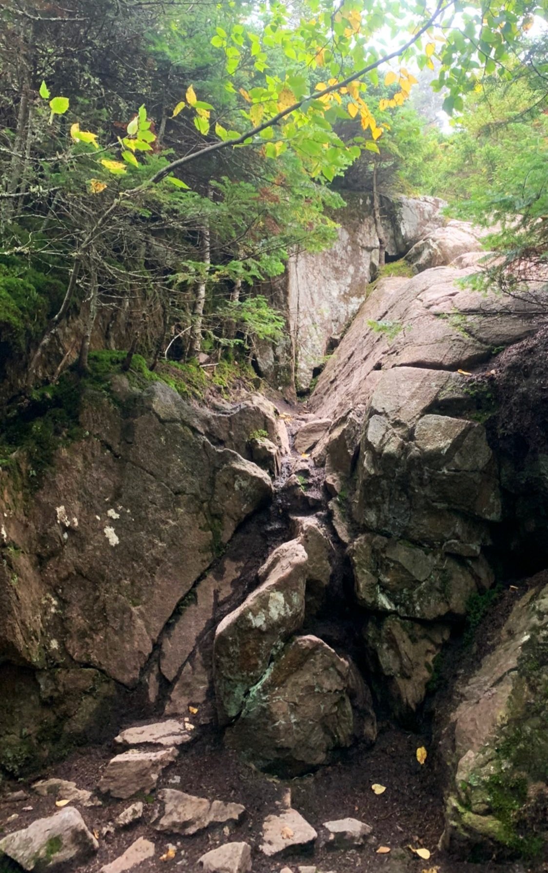
Chimney ascent
Beyond the horseshoe-shaped Outlook side loop, the Success Trail begins to contour around the 3,335’, northern sub-peak of Mount Success, a series of boardwalks and bog bridges elevate hikers above the wetland. Dense forest to either side of the pathway had me on alert for any slight rustle in the forest, a moose out for a sip of morning bog water and breakfast, perhaps.
From the ridgecrest, the trail climbs once again, now to intersect the Mahoosuc Trail (AT) at 2.2-miles. New wooden signs denote destinations in either direction; from the junction the trail dips briefly to a col. A short but steep and somewhat technical, rock-ledged chimney is passed before the path lessens its grade and gradually begins ascending up the northern shoulder of Mount Success. The well-worn AT path travels over bare rock and exposed roots while heading up to the 3,565’ summit.
Once referred to as Mount Ingalls on maps, the open-top Mount Success was renamed in honor of the township in which it is located; as I continued to be socked in by a low-hanging cloud, I joked with myself during the ascent that I had Success-fully ascended another peak known for its vast views on a day it would provide no such views.
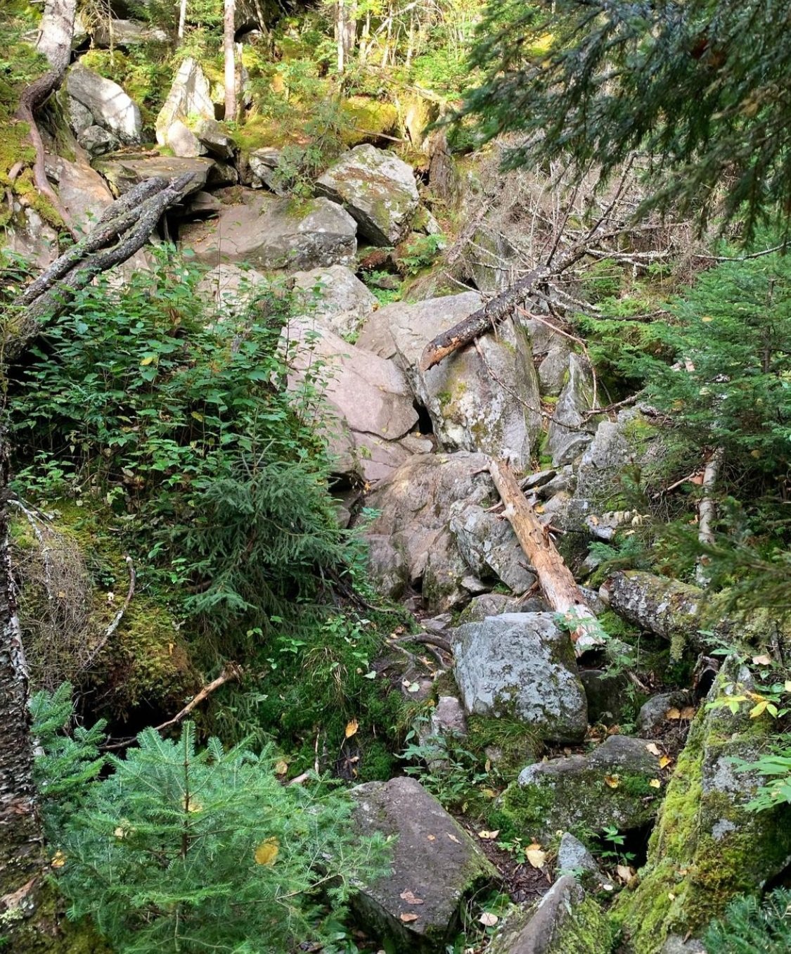
Jumbled rocks of a ravine crossing
Reaching the high point of the mountain I could, however, see just far enough about the surrounding mountaintop to take in a glorious sight of knee-high alpine meadow grasses waving in the morning breeze - perhaps this was the immediate view I had been intended to enjoy this morning.
Turning to retrace my steps back down the 0.5-mile stretch of Appalachian Trail, I could fully enjoy where I now found myself; from shorter, scrappy conifers, the forest quickly transitioned into tall, mature evergreen, filling the cool mountain air with sweet-scented conifer resin as I made the trek back to the low col and steeply back up to rejoin the ridge and Mahoosuc Trail north.

Soft paths of the Mahoosucs
Quickly descending off the southern shoulder of Mount Success’s northern peak, the trail begins tapering downhill gradually at first but quickly looses elevation while scrambling over jumbled boulders - appearing as if a rocky hillside became suddenly scaled up to 100-times its normal size. Luckily, patches of slick mosses have been worn to bare rock from heavy AT traffic in many places, but given the lingering dampness within the box ravine, the massive boulders remain a treacherous scramble.
To the east I could begin to see blue sky on the horizon, perhaps the pesky, lingering cloud layer would burn off after all, allowing views on some of the coming summits. Despite the slowed pace of navigating the jumbled-rock ravines, great satisfaction is gained once able to safely gaze back across the steep valley, upon the boulderfield which was just climbed.

Southerly views from Mt Carlo
Shortly down the pathway, it becomes widened slightly surrounding the tree-mounted Maine/New Hampshire state boundary sign. Here, a thru-hiker was resting and making a phone call (apparently they had service in the forest!). With a wave and warm greetings I continued on down the AT north.
Ascending 240’ in 0.4-miles from the state border, the trail now climbs up a low bump known as Carlo Col; while descending into another narrow box ravine by way of rocky clefts, jagged boulders and slabby ledges - this path is certainly a good introductory taste of Mahoosuc Notch as one hikes northerly toward it.

Goose Eye views while descending Mt Carlo
Passing the junction for the Carlo Col Trail, the next stop is Mount Carlo at 3,565’; Carlo was named for the dog of early trail builder and Mahoosuc explorer, Eugene B. Cook. Meandering gradually up the mountainside, the forest becomes lush and damp; mosses layer over the surrounding mountainside while brightly colored, miniature mushrooms rise from decaying root balls. The path is now a classic well-worn AT trench, dirt underfoot with various shades of greens to either side.
Low scrubby bushes line the trail as it breaks out to the open summit of Mount Carlo; from here, stunningly wide panoramic views are found: east into Maine, along the AT south to Mount Success and northerly toward the rocky-topped Goose Eye Mountain. Beyond the low-laying scrub, the trail descends over open slabs which are often wet and made precariously slick with a layer of fallen leaves.

Nearing Goose Eye Mountain
Reaching the Carlo-Goose Eye col, the trail swings left to ascend the steep, southern ridge by way of several switchbacks up the slope. I had heard of iron rungs located on the ascent up Goose Eye and had actually expected to find them embedded in the rock to aid in climbing this early section, but would run into those later, up the final climb to the summit.
Nearing the aforementioned final ascent, a stunning high-alpine meadow is reached, water trickled nearby as the craggy rock-face of the mountain rose determinedly out of the forested mountainside, sheer ledges streaked the southern face of the wedge-shaped peak, insinuating an intimidating climb looming just ahead.

Ascension aids
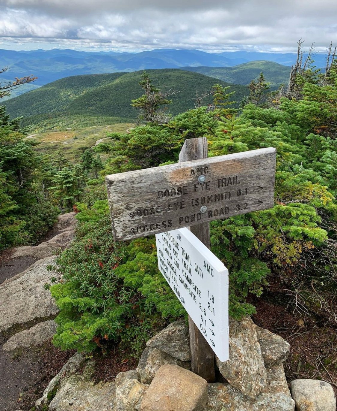
Briefly back into forest, the ominous ledges are reached which offered metal rebar-like rungs drilled and secured into the rock, in which to aid ascent (or descent); upon topping out on the short, steep climb, the Appalachian Trail follows the ridgeline toward the east as the Goose Eye Trail begins and veers left (west) for a short ascent before passing over the summit and continuing down the western-face.
Stunning views can be had from the open summit ledges, looking northeasterly toward Goose Eye Mountain’s north and east peaks is particularly fantastic, harking back to the low-domed, bald summits of the Presidential Range down south. Descending now toward the west, immediately trailside becomes densely lined with low scrubby conifer. Scrambling steeply down several ledgy rockfaces the trail re-enters the boreal forest and descends a narrow corridor of wet, mossy slabs.
Departing Mahoosuc/AT for the Goose Eye Trail
As the Goose Eye Trail gently zig-zags down the mountainside, it briefly cuts through patches of new growth evergreen amongst a mature surrounding canopy. Occasional restricted views open up to briefly obtain glimpses of Success Pond far below.
For a pathway which had been cut 1914 by a Randolph Mountain Club crew before eventually becoming adopted by the Appalachian Mountain Club in 1921, it is impressive how soft the treadway remains after so many years; in many places the trail narrows and grows softer underfoot from a fine bedding of fallen conifer needles.
Eventually, the trail looses enough elevation for the coniferous forest to begin intermixing with hardwood. At 1.6-miles from the summit, the trail once again crosses the Maine-New Hampshire state line, which is well-marked with a surveyors disc embedded in a large trailside rock and tree-mounted signs along the borderline.

Maine-New Hampshire state borderline
Beyond this dividing line, the old forest road continues to gradually descend in a relatively straight, northwesterly direction before entering an area of logging and skid roads. Turning abruptly left at 2.1-miles from the summit, the trail proceeds southwest briefly before merging with a grassy logging road, which it follows for 0.2-miles before diverging (right) back into the woods as the logging road continues left. When I hiked this trail in the fall of 2022, all turns of the Goose Eye Trail were well-marked with arrows made of sticks or cairns when proper white and green AMC signage was unavailable.
Back in the woods, on a near-level stretch, several small tributaries of South Branch Stearns Brook are crossed atop rocks in times of average water levels. Climbing out of an embankment to an old logging road, a left here will head back uphill to the Carlo Col Trail or a turn to the right will return hikers to Success Pond Road and the trailhead parking lot. Once on the old logging lane, a fine view of Goose Eye’s rocky summit can be had which is beautifully framed by nearby trees.
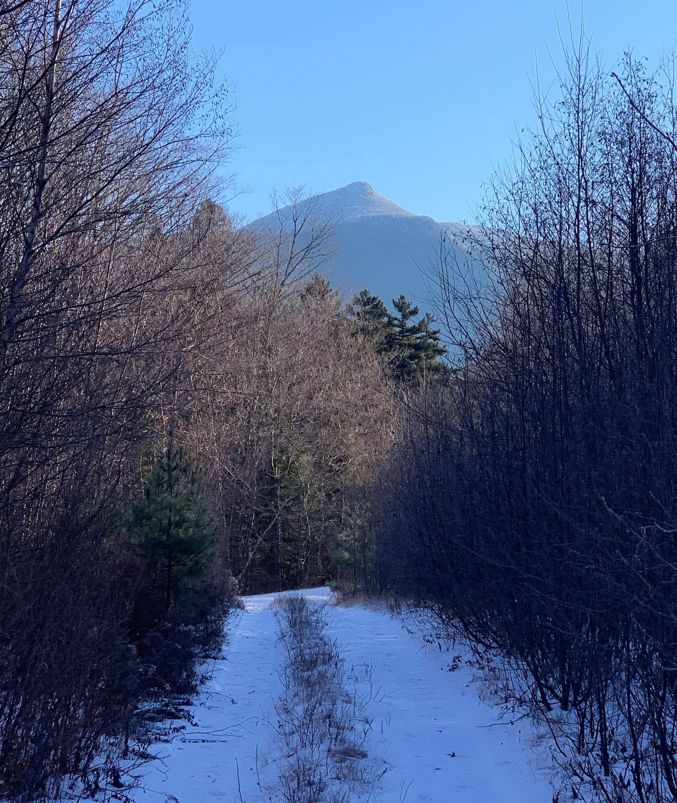
Goose Eye from Carlo Col Trail junction (Nov ‘22 ascent)
Once at the trailhead parking lot, since I was not spotting cars for this hike, there remained a fairly easy, 2.7-mile jog over the softly packed surface of Success Pond Road. This was a very scenic jaunt while following fresh moose tracks for a stretch - to the southeast, the north peak of Mount Success rose up from the rolling landscape, just west of the road I watched birds fly through the canopy while a low bog stretched out far into the distance.
With no real need to get anywhere at a particular time, I alternated between a quick walk and slow jog to absorb the scenery; now that the low-hanging cloud had blown away, all I wanted to do was bask in the warm rays and dry off before making the long drive home. While I was certainly happy to spot my car around the final bend in the road, this loop through the rugged and scenic Mahoosucs was a great way to experience a different side of the White Mountains.
Overall stats for the day:
12.94-miles
6hr 8 minutes
4,629’ elevation gain
Mount Success - 3,565’
Mount Carlo - 3,565’
Goose Eye Mountain - 3,860’