
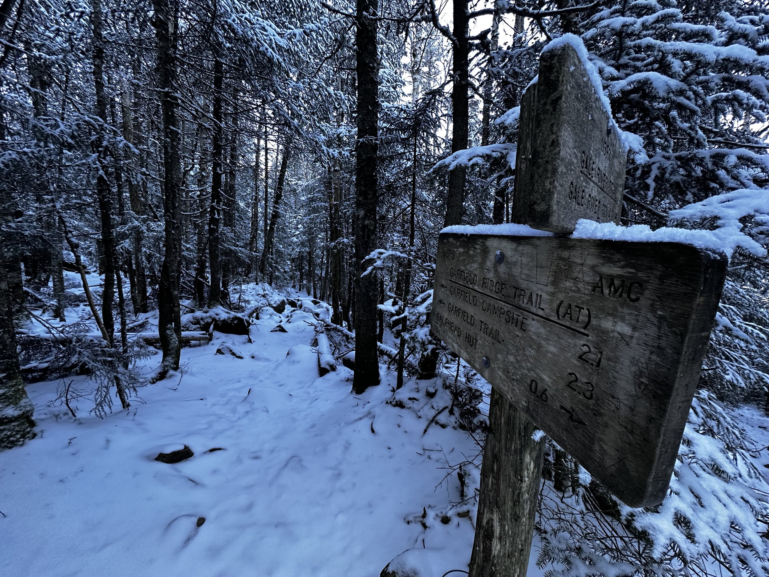
Garfield Ridge - East + West Peaks
After returning from bushwhacking to the summit of Pliny Mountain and discovering that the US Forest Service had already begun readying forest road gates for their closure, it is interesting how the mind enters a certain “scramble-mode”, searching to organize the mental list of hikes and bushwhacks into columns of “inaccessible” until spring, and others which can still be accessed under northeastern winter conditions.

Beginning along the Gale River Trail
With this in mind, several adventures remaining on the New Hampshire Hundred Highest list may be deferred until post springtime thaw, however, one may also find joy in navigating the logistical puzzle which is access to lesser-known peaks, including the dizzying array of directional options for climbing to a trailless mountaintop. While it is understandable that some may simply like to throw a trailhead into their GPS app, slip comfortably into a state of “auto-pilot” until arriving at a well-groomed AMC parking lot; oftentimes, some of the most exciting climbs take a bit more research and ingenuity: plotting and planning access possibilities, in which to approach and access a trailless peak.
With reports (confirmed by USFS/WMNF road closures listed on their website) of Zealand Road vehicular travel being shut down, I noticed there were hitherto no reports on the status of Forest Road 25 (Gale River North); knowing if the gate was closed for the season, I could continue about a mile further along US Rt 3, to embark on the journey from the Beaver Brook cross-country ski trails. This is oftentimes an alternate route in which to access Galehead Mountain and the surrounding forest area in winter months, when the gates are locked.

Surrounding hills dot the horizon
Luckily, the gate for Gale River Loop Road was still fully open at 7am, when I arrived on scene; thankfully, I would not have to leave my vehicle in a parking lot/trailhead which has become prone to so many break-ins. The forest road appeared to have received loads of traffic since any recent snowfall - in fact, sections even appeared to have received a light coating of sand for tire traction; even Forest Road 92 was open and also displayed signs of recent traffic. Into the Gale River Trailhead I pulled, first car in the large parking lot for the day, there would be one other when I departed around 1:30pm - quiet day in this neck of the Whites!

Log bridge along the Gale River Trail
At 7:23am I stepped out of warm Subaru and into 8° morning air, eager to cover distance and get the viscous blood moving again. Stepping foot in a familiar forest once again, however, now devoid of all foliage, surrounding humps of mountain rose up - most of which I had never witnessed from this vantage. The Gale River Trail begins with a mellow, old logging road grade, soon crossing a small tributary waterway to the North Branch Gale River; rock tops were frozen over, much of the exposed river water had solidified as well - its air droplets now locked in time as they once tried to flow downstream.

Becoming rocky nearing the Ridge Trail
Following old logging corridors, the path is highly visible and nearly unmistakable as it slowly gains elevation along the westside of the North Branch Gale River. Despite a healthy blanket of hardwood leaves covering most of the forest floor, the rocks which comprise the trail bed were visible, poking through and ready to snag a boot. Water bars and other admirable trail work toiled to route drainage off the trail surface. Evidently, the arctic air of early November had caused most of the surface mud and soggy patches to completely freeze over - while I had become accustomed to staying alert for snowy postholes in winter, it was interesting to be trekking atop deep, muddy postholes which were now completely solid and frozen in shape.

Current trail (left), old trail (right)
Nearing 1.6-miles into the trek along the Gale River Trail, one finds a sharp bend as the current trail swings up and away from the waters edge; here, a very brushed-in trail can be found, the original route of the Gale River Trail, abandoned for likely many reasons, the most noticeable of which being the removal of several stream crossings, which were likely menacing in times of high water, or winter travel.
Well into the 2011 reroute, the trail surface remained frozen mud tracks, some exposed roots which became simply obstacles to navigate over, rocks were minimally problematic through the reroute section. The forest varied from pencil-like conifers, which I was terribly pleased to traipse through at such a low elevation - to a well-rounded mixed forest, as the trail continues to slice upslope. Occasional stepping stones help aid crossing several low-volume drainages as they flow downslope, toward the main waterway.
Fresh powder along the Garfield Ridge Trail (AT)
Thankfully, despite rocks and boulders being lightly dusted in fresh powder, there was nominal ice to contend with until reaching the Garfield Ridge Trail, higher up. The final mile or so of the Gale River Trail becomes agonizingly steep, with uphill progress slowly made atop a long boulder staircase which extends, oftentimes, as far as one can see up the trail.
Upon reaching the Garfield Ridge Trail at 3,385’, I watched footprints all lead toward Galehead Mountain and the AMC hut (closed in winter). I would now trek westwardly, along the Garfield Ridge Trail, with no visible foot traffic - lots of birds and small mammals had scurried hither and thither, perhaps searching for a morning snack.

A freshly dusted South Twin
This eastern ridge of Mount Garfield has been described rather eloquently and accurately by former writers of the AMC White Mountain Guide when they said the ridge was, “sort of an endless up and down.”
With no traffic and zero noise pollution, I found a sense of absolute peace while strolling along the Garfield Ridge Trail; its dense coniferous canopy shaded the corridor, casting a cool blue hue across the brightly glistening snowfall; despite 5 to 10-mph winds forecasted for the higher summits, winds of much greater voracity thrashed through the scrappy spruce, as if working to create the next generation of wind-twisted krummholz along this alpinic delineation.

Garfield Ridge East Peak summit
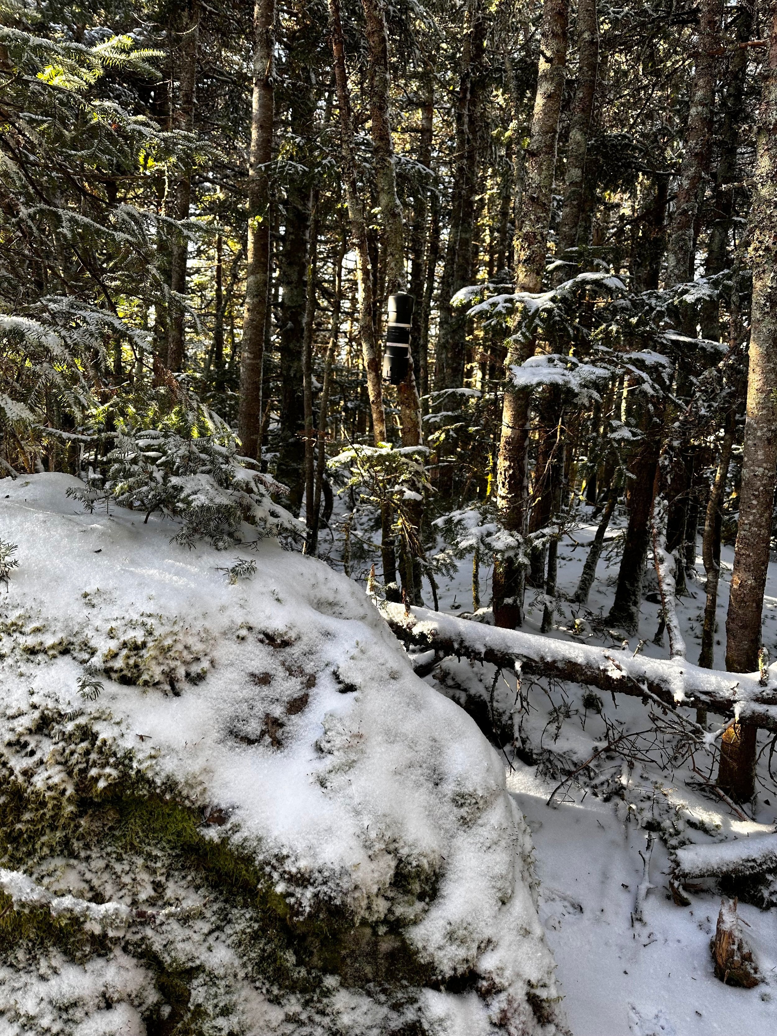
Fighting the notion of saving the shorter spur path to the summit of Garfield Ridge East Peak until the trek out, I could not resist the urge to go find the matte black PVC canister and have a sweet taste of what morning views would accompany this summit celebration. With great determination, I gently pressed on the cap, snapping gently the thread sealant which came in the form of rime ice and snow. After thumbing through the previous several entries and studying the traffic pattern based solely on summit register entries, I saw some familiar names, authored my own entry and restowed all of the contents back into the slender plastic canister.

Soft footing along the Garfield Ridge Trail
Feeling like a kid who had just opened half of their Christmas presents and was now on a mission to locate the remaining gifts, there was a certain cheerful ambling which took place, as I navigated and shimmied between boulders to move over the “endless up and down”, of Mt Garfield’s eastern ridge. I took great pleasure observing the subtle bumps and knobs which had hitherto not caught my minds attention; generally, while traversing this section of Garfield Ridge Trail, it would be with another lofty destination in sight. Today, I was constantly where I needed to be and as the morning unfolded around, I practiced the patient art of ticking off footsteps; one by one, I would eventually arrive at my next destination.
Remembering the coming section in warmer weather, I cast my gaze down the rock slabs which adorned the Ridge Trail; now a flume of thick ice streaked in every rusty shade of eggshell, pumpkin and umber hues. Glad to have brought my older Hillsound spikes, I added the spiked chains onto each trail runner and suddenly felt nearly unstoppable - I had the power to (delicately) walk right across this slick ice flow. Still, with cautious steps to start, I hesitantly tested out my new traction, finding that the solid ice underfoot had formed more resiliently than the dull spikes wanted to purchase, I made it work.

Freshly glazed mountainside
Rolling all the while, I kept expecting to double-check the map and find myself passing the West Peak, with countless other bumps along the ridgecrest now skewing the topographical image I had formed in my mind. Several beautiful lookouts along the ridge trail can be found (especially in winter), which offer glimpses of the West Peak or the eastern crest of Franconia Ridge, or back the opposite direction, the massive bulk of South Twin rises up like a wooly mammoth following a dust bath.
After descending what felt like much too far down a glazed slab of earthen sidewalk, I reentered a patch of shaded spruce which rose high toward the south (climbers left). Passing a thin area of forest, I thought to myself about whether that could have been the notorious herd path. I knew on the map where I would personally choose to enter the pathless woods, had there been no preexisting pathway wore into the hillside.
Garfield Ridge West Peak summit
About 30’ beyond the first questionable herd path, I found a faint secondary route diverging into the wilderness and took it. A narrow trail, made wider and inevitably visible by a corridor of broken conifer branches, what I followed stood out thanks to a fine dusting of fresh powder atop the trampled moss. With soft steps, as to not tear out fragile, frozen mosses with each footfall, I switchbacked around tree trucks, picking a route of least resistance up the trailless mountainside.
Reaching one area of bouldery pedestal, I glanced around quickly as this location could have served appropriately as a summit platform or gathering spot at 3,667’. Recognizing the nearby hillside rose even higher still, through a thick patch of stickly fir boughs, I performed my patented “fir-swim”, where arms and legs are both employed to propel oneself through thick, tangled conifer boughs with minimal vegetative destruction.

West Peak summit register
After several instances of restricted movement and trying to keep branch ends out of eye sockets (forgot the typical eye protection at home today), I emerged at a continuation of herd path, now, with minimal navigational efforts, I simply followed the trampled vegetation to the recognized high point of the Garfield Ridge West Peak. Minimal to negligible views are to be reported from atop this minor peak, but I suspect that if one pokes around, perhaps a miniscule lookout could be gathered through restricted openings in the summit canopy.
After reading more summit register entries and penning one of my own, I returned the notebook, pencils and sharpener to the double layer Ziplock bag, rolled it all up tight and replaced the bundle to the canister; cautiously threading the cap back on; again, I left the cap somewhat loose (but not floppy) while recalling the struggles of prying and twisting frozen caps in wintertime.
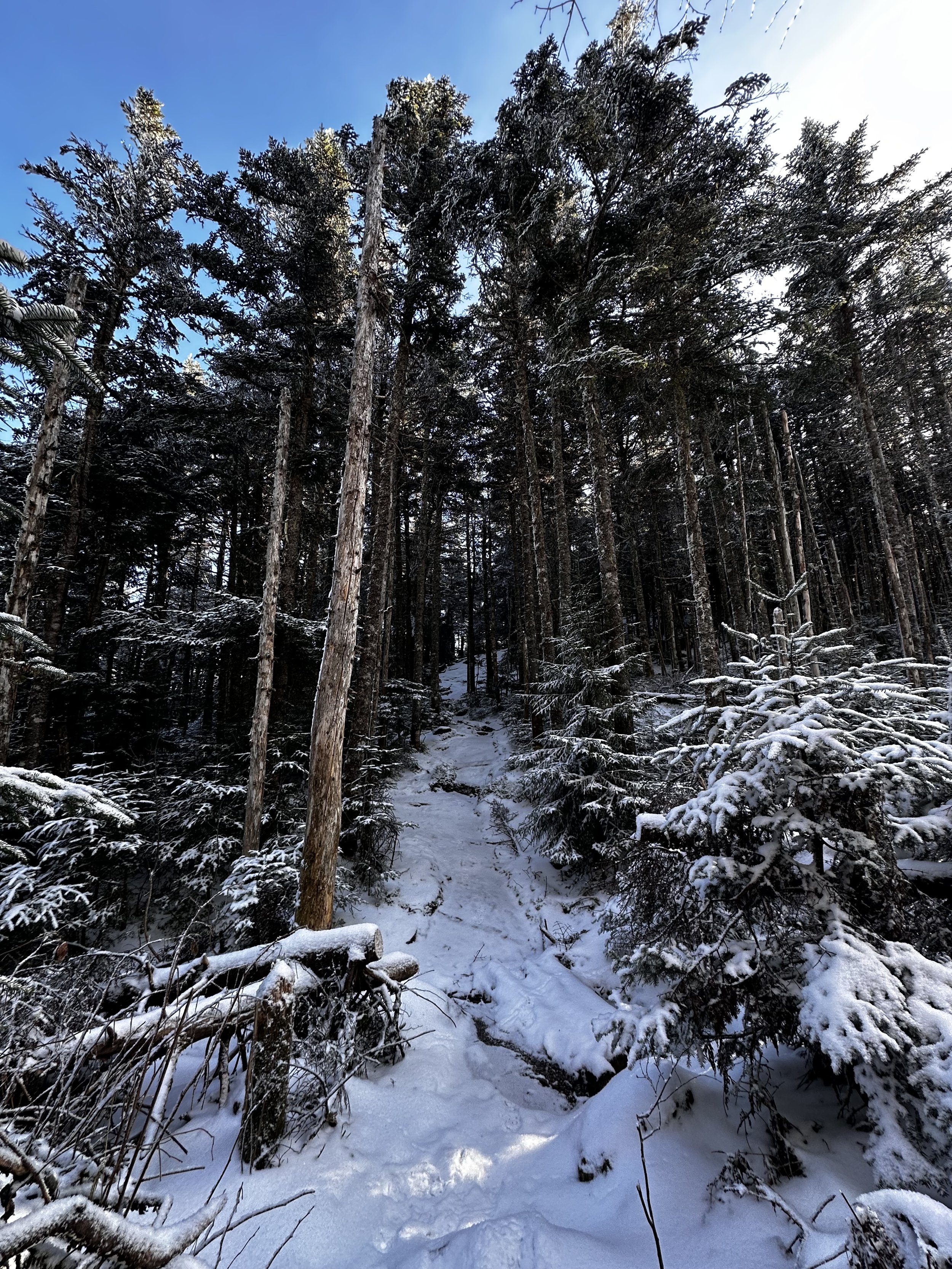
Garfield Ridge Trail ascending the East Peak
Opting to not simply backtrack via ascending tracks, I set off from the highest slope of the summit cone in a more north-northeasterly direction, before striking due north, to bisect and rejoin the Garfield Ridge Trail a bit more toward the east, this time. Overall, the woods were enjoyably open, only stepping over one cluster of toppled tree trunks, I worked to stay alert for both unstable footing and any large animals who may be bedding down in tranquility found on the West Peak.
Upon reaching the furthest objective of my hike, I was pleased to now be following my ascending tracks back downslope. The satisfaction of trekking an out-and-back route as opposed to a loop trail: aside from roaming wildlife or hunters, I now knew all obstacles (trail conditions, water crossings, etc.) which lay between me, in the forest, and my Subaru. Hillsound spikes remained on trail runners for traction until all of the rocky staircase sections of Gale River Trail had been descended - beyond that, the trail system welcomed a hastened trot, with no icy surprises. Recognizing one extra set of tracks in the snow, I visually tracked them veering eastwardly along the Garfield Ridge Trail, the hiker trekked toward Galehead at some point while I was meandering along the Garfield-side of the ridge; otherwise, I never saw any other hikers during the entire morning out exploring.

Galehead Mountain from Garfield Ridge
Arriving back at the trailhead, I sat momentarily, contemplating and mindlessly observing the immediate silence of a forest settling down for another winter, become broken by the clanking, clamorous clatter which has become the busy universe playing out one instant at a time.
As the gate for Gale River Road remained untouched at 1:30pm, when driving by, I could not help but become inquisitively curious if the road might remain open for several more days. Upon arriving home that evening, and checking the USFS/WMNF road closure update, it came as little surprise when I now found the Gale River Road status listed in all capital letters: CLOSED
Cordially, I welcome the arrival of winter, with its hefty overnight dumpings of towering snowfall, to the logistical game which has become the art of accessing trailless peaks in winter. There is a different world out there to find and explore in the northeastern mountains; a beautiful scene where snowflakes can be heard landing atop one another, and winter wildlife disclose their secret hiding spots to only those to invest the time to visit their special residences.
Overall stats for the day:
10.55-miles
4hr 11 minutes
3,402’ elevation gain
Garfield Ridge East Peak - 3,590’
Garfield Ridge West Peak - 3,667’

Close-up of South Twin’s snowy texture