
Cobble Hill + Moody Ledge + Green Mtn
Over the mountains and through the woods, past old orchards and various farming community relics; with snow continuing to melt in the higher elevations, today was a great day for bushwhacking more lower peaks and roaming old farm and logging roads.
While looking over topographic maps of an area of the White Mountains which I had yet to survey, I had a few smaller peaks on my mind in which to explore, off-trail. The 2,306’ Cobble Hill would be the first on my list; Moody Ledge at 2,326’ would be next, possibly followed up with Green Mountain, the lowest of the day, at 2,183’, if time and conditions permitted.

Beginning along the Cobble Hill Trail
Beginning at the southern terminus of the Cobble Hill Trail along US Rt 112, I was happy to find space for several vehicles to the western edge of the pull-off. The road (FR 310) is gated shortly from the highway with signs nearby stating this is an active logging area, although I’d suspect they might be waiting for soggy roads to dry out a bit; regardless, I was parked well out of their path.
At 6:40am I began up the wide Cobble Hill Trail, which, at this point, was a full-on logging road. Several lines hung low from telephone poles while nearby several large conifers had been freshly cut and cleared from the roadway, probably damage from the recent wind storms.

Nearing the height-of-land on the Cobble Hill Trail
Immediately, upon departing the trailhead parking area, the road follows slightly west of Dearth Brook, with beautiful cascades trailside. Various spur roads depart while the main road gently makes its ascent to the 1,750’ height-of-land; it appeared most logging traffic had turned at South Landoff Road and began heading westerly, for the Cobble Hill Trail grew increasingly eroded and washed out in areas. Several minor waterways were crossed atop small rocks and boulders, most made even more slick from a fine coating of moss and leaf litter.

Bushwhacking toward Cobble Hill
In better sections of the old road I found it easiest and driest to trek directly between the deep, waterlogged tire tracks. The low domes of Cobble Hill and Moody Ledge rose abruptly on either side; the forest to my east and first objective appeared to be decently open hardwood with hints of fir beginning near the trail. Fearing I’d hit more conifer with low-hanging, dripping branches I began my bushwhack at 2.0-miles, veering off-trail at just under 1,800’.

Ascending Cobble Hill
The understory had yet to grow in and with the mixed forest well spread apart, travel was quick and efficient - even having no issues meandering around small patches of blowdown. All the while, straight ahead I could see the steep western-face of Cobble Hill rising up. By my ascending route I ended up hitting a steep wall of mossy rocks and boulders for the final 300’ push; all of this precariousness would be avoided by descending straight off the summit due west (south of my ascending tracks).
Once I had scrambled up the steep face of the mountain I still had to track back south over a more gentle ridgetop grade; along the way to the high point I passed several red White Mountain National Forest boundary markers, which I would again see many of throughout my morning hike.

Summit of Cobble Hill
Reaching the high point of Cobble Hill I found the recycled peanut butter jar canister which had at least an inch of discolored water inside, I dumped out the liquid but with the summit register notebook sopping wet, I kindly replaced everything as dry as I could muster up and continued along my way. Descending due west off the summit area was much easier than my ascending tracks, here I found more conifer needles and fallen leaves with far fewer exposed rocks and boulders to contend with - turns out those were all waiting patiently with hoards of fallen birch trees further down along the gentler grade which would guide me back to the Cobble Hill Trail.

Moody Ledge through the birch grove
Apparently I’d crossed my ascending tracks down near the forest road but never recognized anything familiar; assuming the sight of fairly decent woods which lay ahead might be the best I’d get for Moody Ledge, I veered straight in and began finding remnants of old logging or forest roads - all around were loads of recent moose and deer activity but I wasn’t certain they could craft the 2’-wide paths which I was finding.
Along the lowest, flattest area of the col was a very boggy patch which I crossed atop moss-covered logs; at the far side of the wetland I was pleasantly surprised to find a very peculiar cut through the dense balsam fir, a hobbit trail of sorts. While never needing to push through any dense branches, this side of the forest was nothing like what I had been imagining I would find.
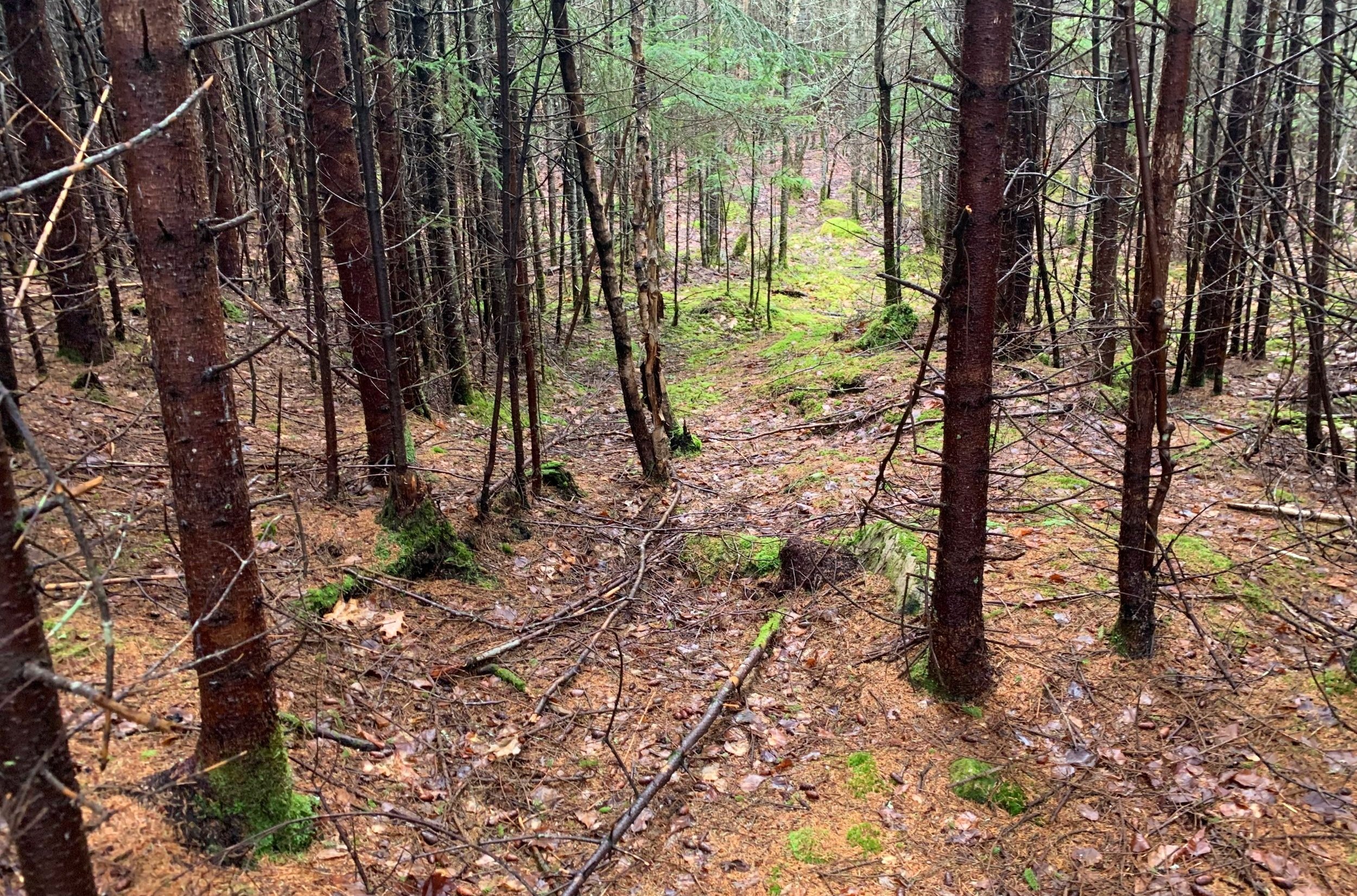
Conifer corridor enroute to Moody Ledge
Beyond the conifers, the forest opened up to many low evergreens and moss-covered blowdown. Small boulders had been covered over with a thick layer of leaf duff, with a bit of care the trekking was remarkably soft underfoot and actually rather enjoyable.
As I gained elevation, moss grew deeper and began overtaking the leaf-covered forest floor until all around - in any direction I’d glance - was a sea of 4 to 6”-deep, vibrantly brilliant green moss; while this was a sight unlike anything I’d seen prior, this was certainly a cushy mountainside carpet unlike anything I had ever trekked atop.

Mossy carpet nearing the Moody Ledge summit
After a long, gradual ascent, the high point of Moody Ledge was not hard to find, the orange-wrapped glass canister stood out amongst the dark, wet spruce bark and green forest floor. Thankfully the contents of this summit register had remained dry and could log my ascent onto the small, handmade notebook contained within.
I glanced briefly around the summit area - if there was a ledge on Moody Ledge I certainly wanted to find it, not today, however. Knowing from looking at topographic maps last night that I could meet up with the north-south running Orr Hill Trail and use that as my exit route, I was aiming at Green Mountain which lay just beyond this trail; I’d depart the summit of Moody Ledge and follow the northwest ridge, that was the plan at least.
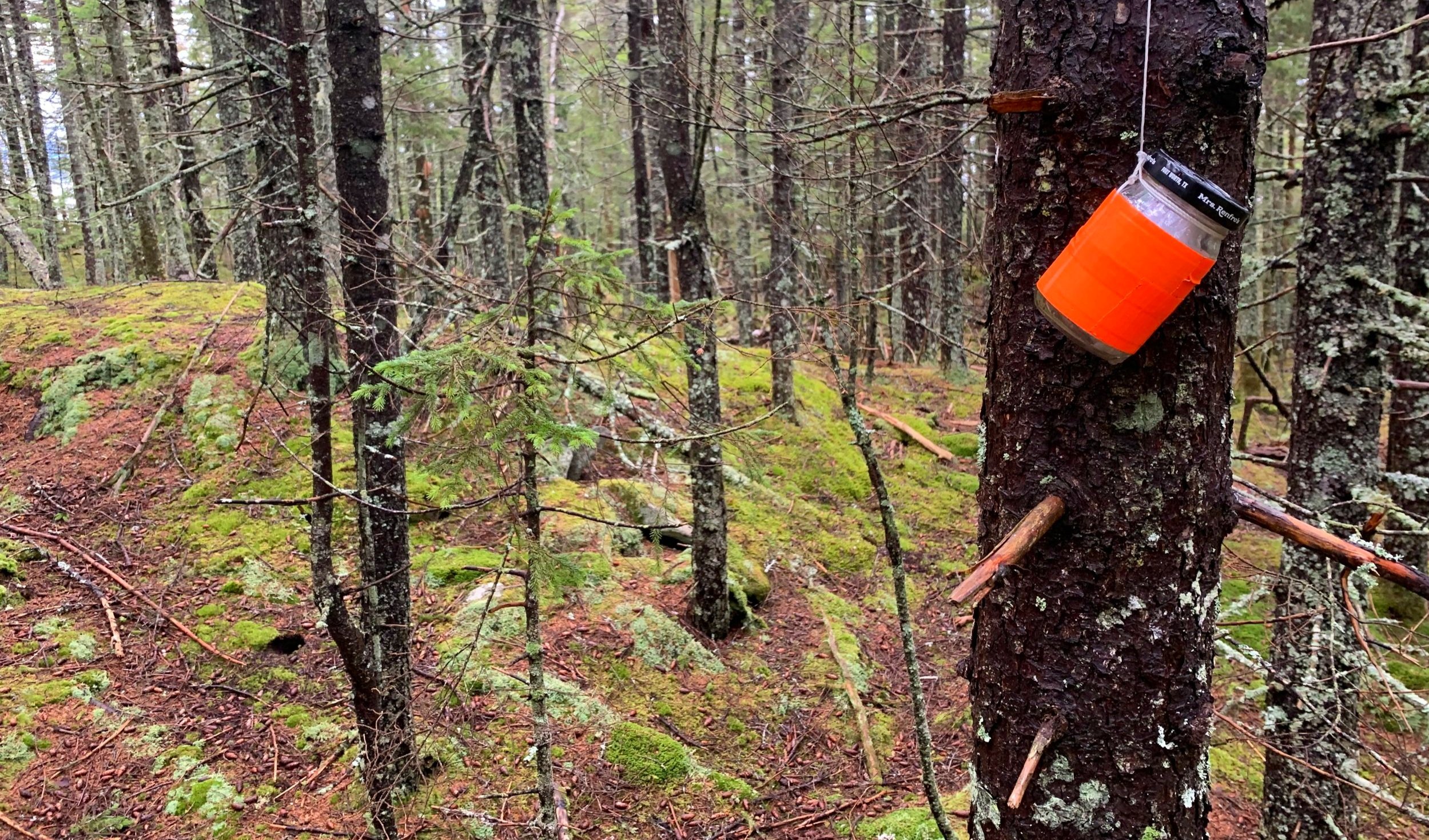
Moody Ledge summit
Initially, upon departing the summit, I found more pillowy, deep moss, but once I had reached ~2,150’ I had plunged into a wall of 6 to 10’-tall evergreen, which was dripping with rainwater from the previous day of near-constant showers. Knowing I had a full change of clothes and had yet to get as wet as I thought I could have, I pushed through this wall of conifer, simply hoping it would be a brief patch and soon give way to more hardwood forest.
Thankfully my intuition proved correct, this was a brief 15-20’ fir wave of young growth, beyond which was open forest, again littered with meandering tracks of animals and forest vehicles, making the northwesterly sidehill traverse much easier than it could have been.

Along the crest of the 2,115’ ridge
I was reaching a 2,115’ bump on the map which stood between Moody Ledge and my next stop; initially I thought to trek northerly around the elongated hump but upon second glance began climbing directly up its slope - ascending straight up the hill was much easier for me than continuing to traverse off-chamber along the edge of the hillside.
At the height of this low ridge I reached even more beautiful moss and lichen carpets, bare rock rose through in several areas. Beginning a descent off the northern tip of the ridgeline I began to find hints of a well-traveled herd path; this path guided me directly into a sea of logging cuts with lots of recent moose activity.

Green Mtn in a cloud beyond the logging cut
Picking a grown in pathway which seemed to head in the westerly direction that I needed to trek, I fought my way through head-height saplings which were interspersed with blackberry brambles; underfoot was dense grasses which had toppled, hiding the wet ground beneath; I knew Orr Hill Road lay several hundred feet directly ahead, but what I did not know was if it too was going to be a mess of logging re-growth.
Thankfully the old forest road was in fine condition, as fine as any I had traipsed across up to that point in the morning. As the time was just before 9:00am and the two prior bushwhacks had not been completely atrocious, I made the call to continue back into the trailless forest, to ascend the southeast-facing ridge of Green Mountain.

Ascending Green Mountain
After passing through a brief dip into a wet patch I began the gradual 250’ climb through a pleasant forestscape. At ~2,090’ my northwesterly trajectory brought me right onto a tremendously eroded forest/ATV path; figuring this may guide me somewhat faster to the summit than my current off-trail travel I followed the path right up to the peak where I found a small unoccupied cabin. Despite seeing no one home (from a distance) in the open windows I did not want to stick around and look for a peanut butter jar strung up in a tree, I wasn’t even sure an occupied summit would host a summit register canister anyhow.
Following my tracks back down, I avoided the bushwhack descent and simply followed the road, which was labelled as “Private” at its base - whoops! Knowing my exit path, Orr Hill Trail, was just beyond a short patch of forest I made my final bushwhack of the day. All I had now was about 4-miles of logging and forest road to traverse.

Beaver wetland taking over Orr Hill Trail
Down a gradual decline I jogged a decent pace, dodging small soggy sections along the way until reaching the beaver swamp area and outlet of Petty Brook. I hung along trailside and bushwhacked briefly around the waterlogged stretch of road until the flow trickled off the road and continued downslope, then I picked up the soggy roadway once again, following deep moose tracks which proceeded straight up the center of the path.
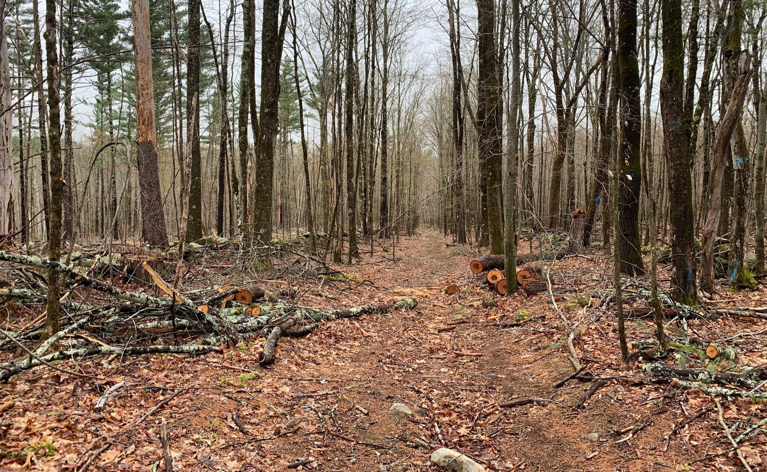
Once I had begun following old stone walls again I found the source of all the recent logging - if the term “devastation” were to be found in a dictionary, I believe there would have been a picture of this exact area. Modern logging at its worst. The old rock wall lay toppled where heavy machinery entered, trees were knocked over and splintered, plucked clean from the landscape, only unusable scraps remained - it looked like a bomb went off in the logging cut; and to make the issue even more ugly - the new waterflow had tore mud and soil from the bedrock in many places, leaving new wetlands in others.

Logging along the Orr Hill Trail
Seeing this utter destruction of otherwise beautiful forest land left me feeling broken-hearted and with a tremendously gross feeling within for so-called “progress”. As I tried to continue down the soggy roadbed, feeling like The Lorax himself, I inadvertently passed several other older cuts where generally a single tree standing abnormally alone on the mountainous hillside could be seen.
Eventually I departed the logged hillside and regained a more enjoyable forest landscape along the South Landoff Road; here I passed ancient orchards which appeared like old, twisted branches of fairy tale apple trees, rock walls lined either side of the roadway as far as I could see into the distance.
Soft footing of South Landoff Road
Even with a few wet patches of dirt road, it was a lovely stretch of old farm road, which was beginning to burst back to life with green hues of springtime - even a porcupine waddled across my path before disappearing into the northerly woods. I found an old foundation complete with piping and plumbing - I tried to imagine what their lives must have been like while living on a farm road such as this.
A final, short stretch of rocky roadbed led me back to the Cobble Hill Trail which I had ascended upon and at whose southern terminus could find my car parked with several sliced apples waiting. Three summits with three very distinct forested mountainsides; hardwood, softwood, mosses and lichens, moose, deer, porcupine - to name a few. There are endless corners of forest and history to explore in these woods while I wait for the logging cuts to regrow.
Overall stats for the day:
9.79-miles
3hr 39 minutes
2,740’ elevation gain

Old foundation along South Landoff Road