
Cascade + Porter Mtns (via Cascade Mtn Trail)
For a couple of mountain climbers, a trip to the Adirondack Mountains is not complete without a trek through the wilderness; specifically, the High Peak Region of the Adirondacks. Listed as the most frequently used trail in the 6.1-million acre State Park, the trail has long been a popular stopping point for hikers and climbers of all ability levels due to its ease of accessibility from US Route 73, and its relatively short (yet steep) route up the southwestern ridge of Cascade Mountain from the roadside.

Sunrise from the Cascade/Pitchoff Mountain Trailhead
The current Cascade Mountain Trail, cut by the Algonquin Chapter of the ADK (Adirondack Mountain Club) and opened in 1974, this 2.1-mile ascent from US Route 73 was essentially a massive reroute to avoid the older, highly used and abused trail which ascended by a more westerly approach than today’s southwesterly swing to the 4,098’ bald-topped mountain. I had hiked this trail several times in various seasons back in 2015-2017, when working on my own round of ADK 46 4000-Footers, but in no way do I recall the sheer damage and widening of this footpath to the degree which can be found more on recent online videos and trail reports.

A plethora of information welcomes hikers to the Adirondacks
Generally, in warmer months, a volunteer Summit Steward can be found with a small table set up at the Cascade Mountain trailhead, with information for the public on how to enjoy the High Peak mountains while working to conserve and protect the trails and wilderness for others to also enjoy at a later time. Despite warmer temperatures, Alanna and I arrived to claim the title as second vehicle at the trailhead for this Thursday morning ascent. The low sun angle graced the underside of any clouds high above as we readied gear and packs, the skyline was aglow with orange and pink hues directly above Upper Cascade Lake - as if a notch had been formed from our vantage by Cascade and Pitchoff Mountains.
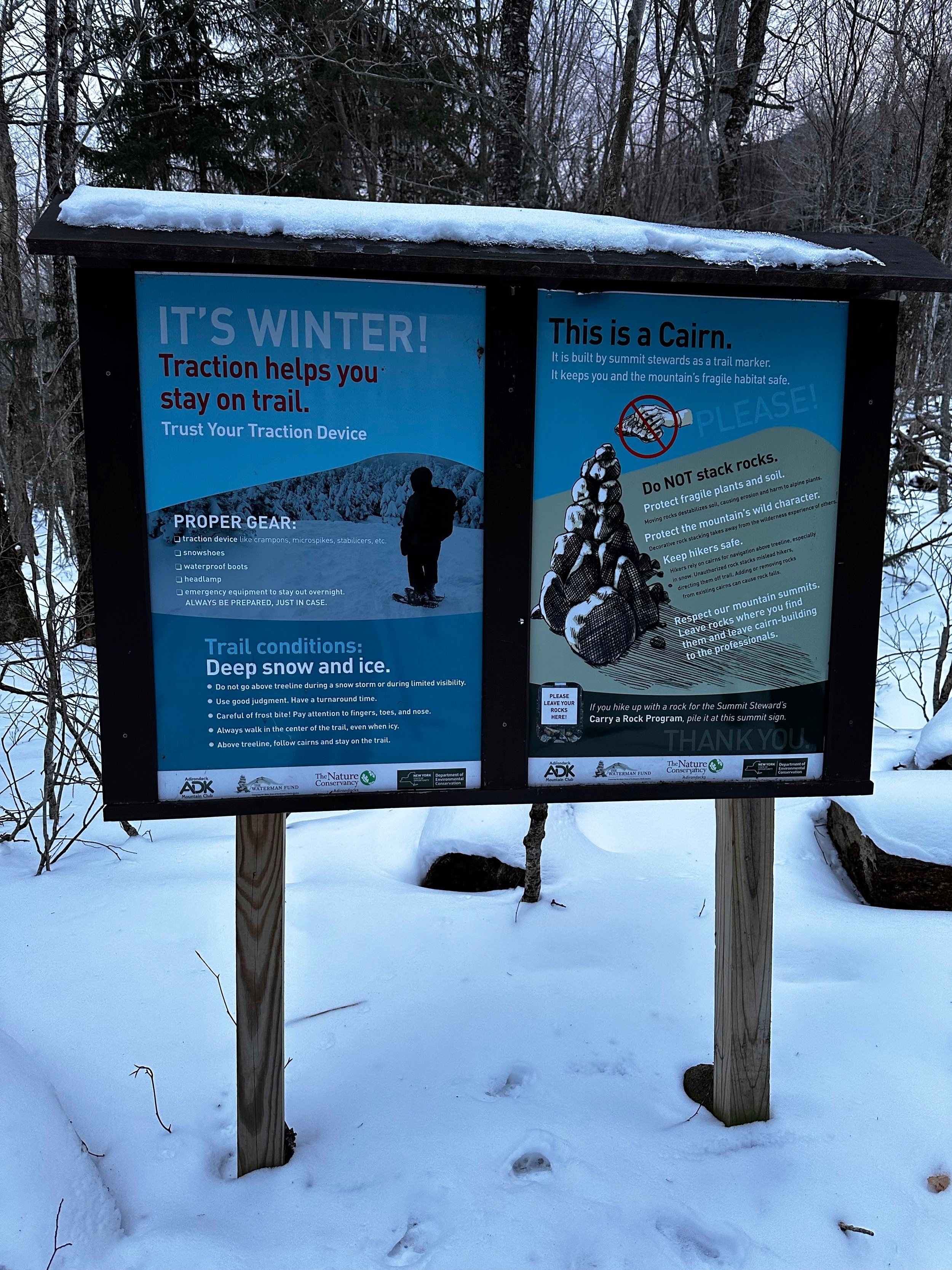
Multi-agency displays encourage proper winter recreation
The current route up this 4000-Footer is plagued with a plethora of reasons why the DEC (Department of Environmental Conservation) and ADK have been working diligently to relocate the highly worn trail once again; during warmer months, vehicles can be found haphazardly parked, lining both sides of the winding 55-mph roadway. The option for a re-route has been in the works for many years at this point, working with private landowners for trail layout and accessibility. The new route will feature a more resilient trail with rock stairs and stepping stones bridging any soggy or steep pitches; over a much lengthier, albeit gradual approach, beginning from the Mount Van Hoevenburg Winter Recreation Complex, thus removing roadside vehicular traffic from US Route 73.

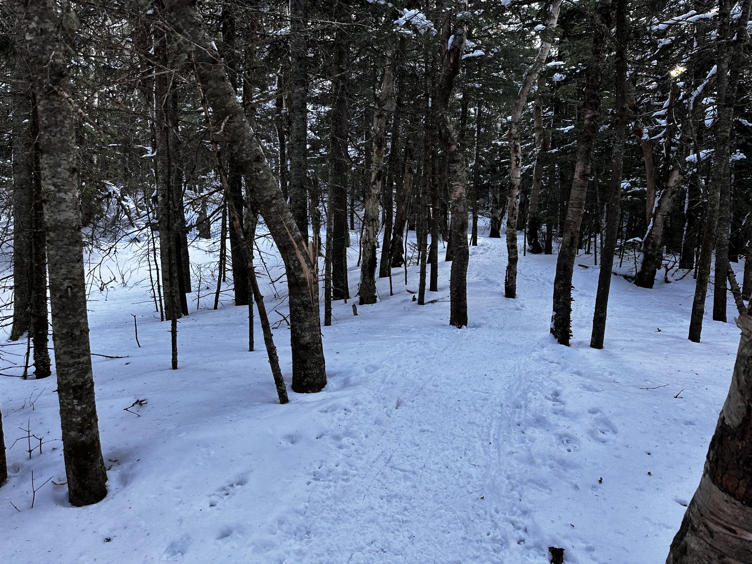
The Cascade Mountain Trail in winter-mode
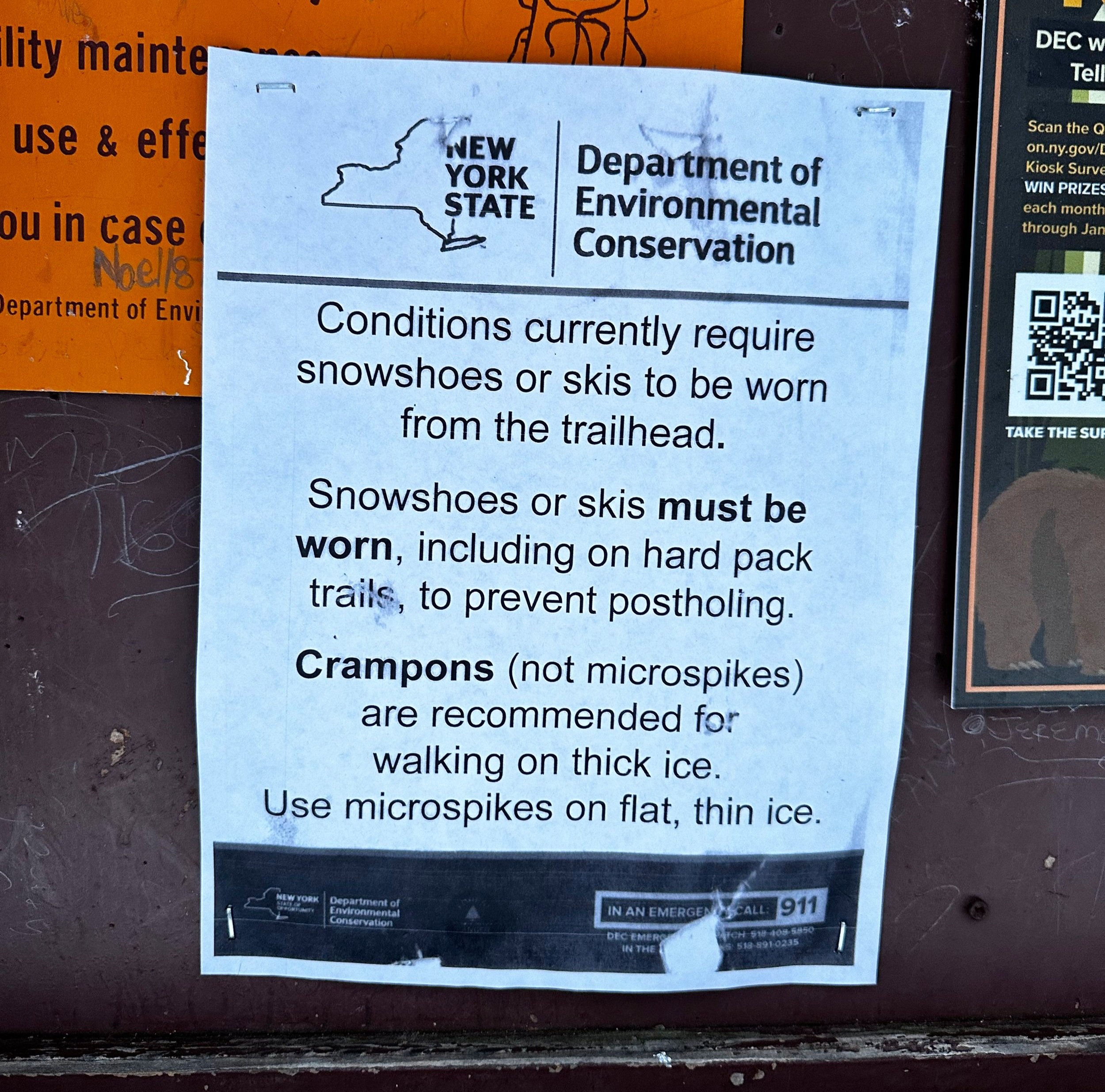
With snowshoes on mountaineering boots, a small, wooden kiosk soon welcomes hikers to the Cascade Mountain Trail. This kiosk contains a register log book where NYS DEC and the ADK encourage trail users to sign-in: listing members of their climbing party, intended destination, duration of stay, brief contact information, as well as a column for hikers to “check-out”, therefore signifying to Conservation Officers or Search and Rescue members which climbing parties may still be out on the trails, whether hiking or backpacking - this is a great system which I was very surprised to see not continue into the White Mountains of New Hampshire. This “check-in/check-out” system not only assists in rescue efforts, but also provides pertinent information regarding trail usage trends (over holidays or seasonally) to the DEC and ADK.
Stunning woods adorn the SW ridgecrest
Once signed in to the Cascade Mountain Trail register, we also took a moment to peruse the newer signs which had appeared since my previous, 2017 sunset ascent - most signboards asked hikers if they had essential gear, adequate time in the day to safely summit and return, as well as information on dogs, and basic Leave No Trace principles - similar to what the AMC offer at White Mountain trailheads, but much more thorough, graphic, colorful, and eye catching than NH educational offerings.
Immediately, we both glanced at the trail and saw not a single posthole lining the most popular trail in the Adirondacks - this was a beautiful sight after the abomination which have become many White Mountain trails this winter - certainly owed to a certain “lawlessness” on New Hampshire trails. The Adirondacks, being a State Park, has legislature in place to effectively enforce snowshoe use on trails which have accumulated 8-inches of snow or more; oftentimes, trailheads may have less than the depth required for required snowshoe use, while greater snow depths can be found at elevation - in these cases, snowshoes must be carried in the Adirondacks, the hiker must be ready to use proper equipment on the fly, or otherwise face a fine - which I can affirm, is enforced in the Adirondacks Mountains.

Early views along the upper Cascade Mtn Trail
What would generally be a rocky and rugged (highly eroded) trench up the southwestern ridge, was a streamlined, snowy route which was completely devoid of any postholes (aside for the occasional trailside, off trail sunk foot), such a stunning sight to behold. Initially, crossing several drainages, most were rendered a simple step-over thanks to the remaining snowpack. As we gradually ascended the Cascade Mountain Trail, the terminal bump of the southwest ridge became clearly visible through the open hardwoods.

Junction for Cascade - Porter Mountain Trails
Swinging to approach the ridgelet from a more eastwardly direction, spruce and fir began to appear alongside massive, wind-sculpted birches, whose bare branches towered overhead. After a moderately steep ascent over and around exposed ice flows, the trail emerges onto the ridgecrest proper for a stunning stroll through mature northern boreal forest. The airy canopy often appearing to disclose old, snowy woods roads or abandoned trail corridors. For 0.9-miles, the trail meanders steadily upslope along the southwest ridgecrest - despite the lofty, trailside snowpack, I could recall the image well of ascending during warmer months, when the verdant forest floor would seemingly be glowing with brilliant, green mosses and lichens.

Approaching the summit of Cascade Mountain
Encountering a rocky shoulder, we found ease in ascending the ledgy vista by following in the existing snowshoe trench as it arced around the bulbous bedrock. From our lofty perch, many snowcapped peaks were visible - the slides of Mount Colden (4,715’) appeared as a beacon from which to gain ones panoramic bearings. Mounts Marcy (5,344’) and Haystack (4,961’) were shroud in a brilliant rime ice, while the remaining Great Range began to appear as a massive, jagged wolf jaw just beyond the forested wave of Big Slide Mountain (4,199’).
Eager to capture even more glorious views from the baren summit of Cascade Mountain, we continued the brief ascent to the first junction through crusty, snow laden evergreen boughs. A packed out plateau area welcomed us to a junction for the Porter Mountain Trail spur, which we would thence take to Porter Mountain; as we could see a hazy blanket of cloud quickly approaching from the northwest, we opted to attempt Cascade Mountain first.

Summit of Cascade Mountain
Following brown and yellow DEC signage, we continued through a brief, wooded section to a clearing where I had found stacks of lumber during my previous ascent seven years prior - having been helicoptered in for bog bridges and other trail maintenance projects. Today, we found no pressure treated lumber stacks, but a group of three climbers enjoying a warm cup of coffee following their alpine start and sunrise atop Cascade Mountain.
Once out of treeline, we followed a brief snowshoe track to the east of the exposed summit until the lingering snow petered out to bare rock. Finding a convenient location between two boulders, we stashed our snowshoes and trekking poles for the remaining, rocky ascent. As most mountaintop snow had melted during the previous days of warm afternoon temperatures and daytime sun, we worked to trek atop either compacted snow or bare rock, as to not trample the fragile summit vegetation - the summit of Cascade Mountain had been scorched by wildfire back in 1903, a fire so hot it was said to melt any patches of soil, rendering the mountaintop baren and rocky - as we currently find, with scrappy conifers and low alpine vegetation working to re-establish its foothold around the open summit.

The broad-topped Porter Mountain as viewed from Cascade Mtn
Overall, following yellow paint blazes on bare rock, rock cairns (built by trail maintenance specialists), or trailside scree walls, we navigated around localized patches of ice, opting for bare rock to place mountaineering boot tread. Once at the 4,098’ summit of Cascade Mountain, we were greeted by substantial winds (forecasted 30mph sustained, 40mph gusts); as the ambient air temperature remained overall tolerable in the morning sun, we stayed for several minutes to soak in the monumental views, and peruse the baren mountaintop for old relics - several US Geological Survey benchmark discs, as well as old eyelet hooks from the USGS triangulation station, remnants from the early land survey days.

Smooth sailing along the Porter Mountain Trail
With careful steps, we avoided any ice sheets in favor of bare rock to descend back to our awaiting gear. We enjoyed a rock-solid, snowy foot path back to the junction. With another greeting as we passed the trio of our new mountain friends, Alanna and I now descended rather steeply atop bulges and flumes of exposed ice; thankful for the sharp crampon points of the Tubbs Flex Alp snowshoes, the descent felt overall solid as the ice was becoming soft from the morning sunshine.
A brief, yet steep, 150’ descent brings trampers to the Cascade-Porter col; ahead, the wooded ridgecrest of Porter Mountain can be discerned through the coniferous canopy. Through more open softwoods, the Porter Mountain Trail now begins to climb, emerging at a significant boulder, around which the trail swings southward for perhaps two rods, passing a short spur which leads to a ledgy panorama - a glimpse of the stunning Great Range vista to come.

Big Slide Mtn with The Great Range rising behind
While similar, the views toward the Dix and Great Ranges are much better, in the authors opinion, than those from Cascade Mountain - as the wooded mass of Porter Mountain is no longer occupying the vista. For several minutes, I traced white streaks along precipitous mountain slopes, as if using snowy rockslide routes as a descriptive fingerprint to pick out and name familiar peaks. Continuing along the Porter Ridge Trail, I quickly encountered a trail unbroken - that was an obvious sign that we had arrived atop the 4,068’ mountaintop.
After a brief stay atop Porter Mountain, and absorbing as much of the stunning panorama as physically possible, we turned to follow the streamlined snowshoe path back downslope. As the south-facing trail was more exposed here to daytime sun, we noticed a mild slushy quality developing underfoot, in our morning snowpack. While snowshoes are required, we saw many morning climbers simply ascending in Hillsound spikes, with snowshoes strapped to hiking packs, their smaller, narrower footprints clearly leaving divots in the softening snow.

Marcy, Colden, and Algonquin Mtns clearly visible from Porter Mtn
While happy to have snowshoes on our feet, quick work was made descending the packed out trail, back down the long southwestern ridge of Cascade Mountain. Upon reaching the location atop the ridge, where we would soon make the final descent through open hardwoods back to our awaiting car, I inquisitively stepped off trail to find what might be waiting atop the wooded bump at the far southwestern terminus of this ridgelet. The snowpack was perhaps 4-inches of soft, slushy snow; picking a route through spruce and fir, I worked to bob and weave around eye-level branches or occasional forest floor debris.

Minor lookout from atop the wooded SW ridge knob
Reaching the wooded pinnacle of the knob, I was pleased to locate a small, restricted view southward, more-or-less a window which offered a glimpse of wooded ridge of Porter Mountain. Satisfied with a brief bushwhack around the Adirondack High Peak region, I followed my ascending snowshoe track back to packed trail, where a downward snowshoe trail run would unite Alanna and I once again, as she opted to forego the brief ‘whack. Had the trek been any further, we obviously would not split our two-person group in winter, but knowing my side-excursion would likely only take mere minutes, we concluded this to be a relatively safe option, as we were now encountering lots of uphill hikers.

Cascade Mountain from Porter Mountain
During the final stroll back to US Route 73, we talked about our findings - differences and similarities of trekking in the Adirondacks of New York versus the White Mountains of New Hampshire. It is not hard to find aspects of both mountain ranges to draw us to seek either out. The most pressing subject of our downward stroll revolved around how we can encourage hikers of our new home mountains to tramp with more care, respect, and thoughtfulness of others - to want to protect winter hiking trails from pesky barebooters - who will turn a beautiful, streamlined, snowy trail corridor into Swiss cheese during one warm afternoon; which is honestly much more important than hiking one’s own hike - frozen postholes produce a treacherous, dangerous route once refrozen, therefore negatively impacting the experience of the next to stroll through.
NYS DEC dropping knowledge - evidently it works!
This worked out to be a stunning climb with glorious views; a fine way to enjoy the old, beat up Cascade Mountain Trail, before this too is decommissioned due to overuse, erosional, and safety concerns. Next up: the new Cascade Mountain Trail from the Van Hoevenburg Ski Complex, once open and available for foot traffic!
Overall stats for the day:
6.17-miles
4hr 22 minutes
2,936’ elevation gain
Cascade Mountain - 4,098’
Porter Mountain - 4,068’