
Guadalupe Peak (Texas HP)
Finding ourselves camped directly atop the Central-Mountain Time Zone delineation, we were unsure if the real time was 1:15, 2:15, or 3:15, when our 2:15AM alarm rang. Outside the tent, the mountain air was calm, aside from the occasional road noise of vehicular traffic along US Route 62, to our east, all was silent. We arrived from New Mexico the previous evening, pulling into the Pine Springs Campground just as a dark tempest finished passing overhead.

Twilight start at Pine Springs Campground
Over a mug of warm, black coffee, we readied light packs with extra clothes, snacks, and water bladders; I had anticipated an ascent of Guadalupe Peak, the highest point in Texas, since camping here nearly a decade earlier, only to be shut down due to dogs. This round, it was only Alanna and I, along with 45-minutes of tales spun by two gracious campground hosts who stopped by to welcome us the first night.
We had scouted the lower section of trail during a sunset ramble the night prior, now knowing exactly where to point our headlamps, and which rocky trail corridors to venture along. A large map can be found at the hiker information kiosk before setting off. Restrooms, potable (and non-potable for camper dishes) water can be found near the flush toilets - it is worth noting how clean the campground hosts had upkept the facilities around the campground and trailhead area.

Early sunrise color along the Guadalupe Peak Trail
Nearby, a US Forest Service Visitor’s Welcome Center can be found on the right, just prior to passing the campground access road; beyond the campground area, a large, asphalt parking lot is the trailhead for several trails through the canyon, the Guadalupe Peak Trail being just one of such trails. Since we were camping, our kind hosts welcomed us to keep our tent set up, to allow it to dry in the morning sun, as this was not their busy season, the Welcome Center was not even open when we visited, but that also may have been a wildfire related closure.

Ascending the Guadalupe Peak Trail
My watch read 3:50AM when we departed the campsite; however, my phone read 4:50AM, while Alanna’s read yet another time - we hoped to catch sunrise from atop the state high point, but would appreciate standing atop the summit with, or without a sunrise. As we walked to the trailhead, surrounding hills, still blackened shadows in the nighttime sky, were only discernable by blotches of missing stars from the skyline - the stars we did see seemed to shine a bit brighter in this corner of Texas.

Cloud-covered El Cap (left) with the low Patterson Hills
Prickly pear, and other low cacti grow in localized clumps around the trail, the sight of such pointy, colorful plants is something we were certainly not yet accustomed to. Headlights drifted side to side, searching for any wildlife as we made progress along the trail. The Guadalupe Peak Trail was very dry when we visited in August; a compact, graded yet rocky treadway, some sections appeared to have received some degree of maintenance, with river rocks filling areas of past erosion.
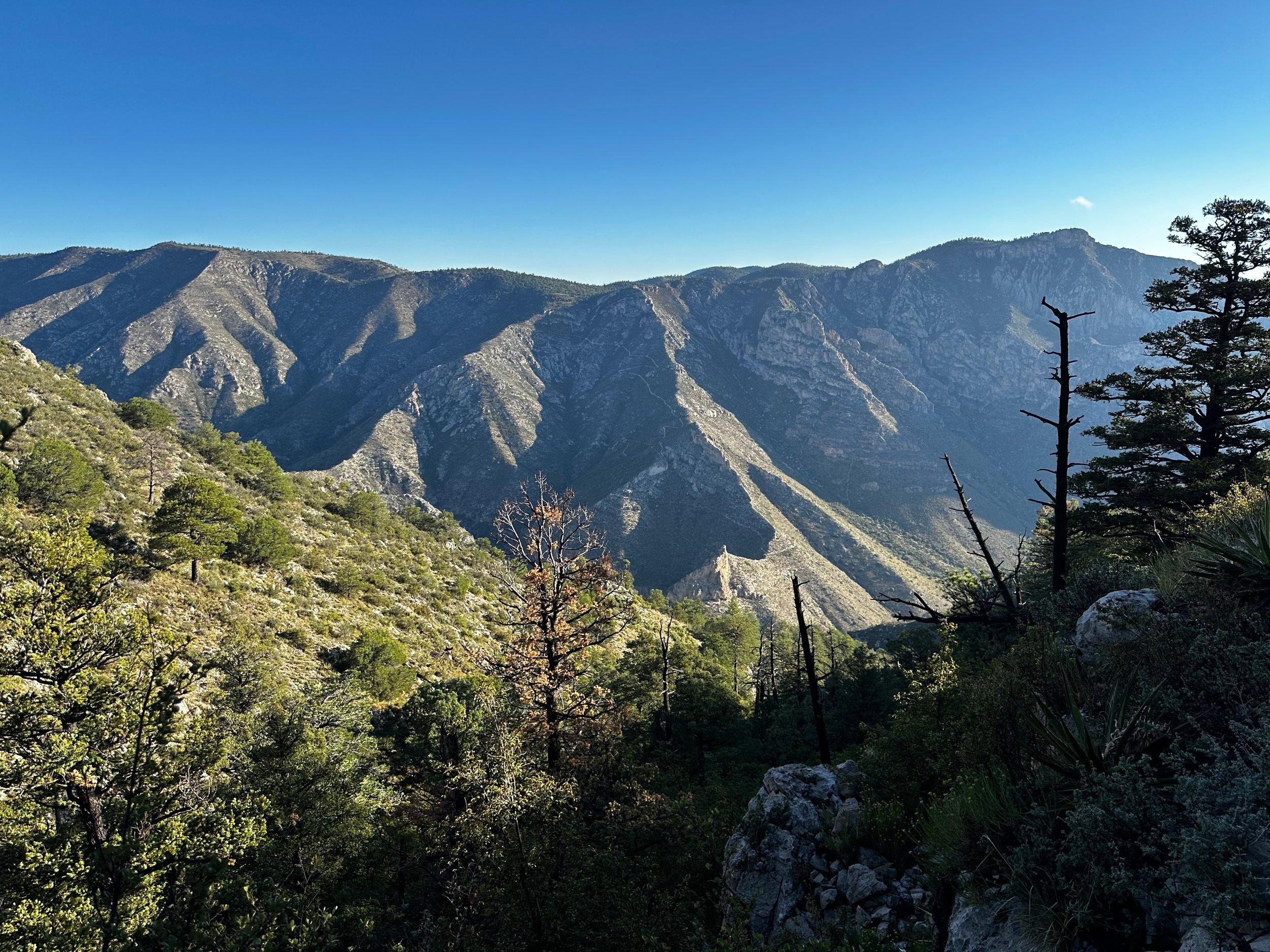
Following waist-height metal trail direction signs, we made a series of zigzags to remain on the Guadalupe Peak Trail; a horse path diverges right, and the El Capitan Trail departs left, contouring a long route around the southeastern base of Guadalupe Peak, and eventually the El Capitan massif itself.
Nearing the high point of Texas
As the trail becomes steeper, it ascends atop rock slabs and steps, at points where the trail switchbacks, it is easy to spot grossly eroded streaks, nearly straight downslope as the trail zigzags. While it may be tempting to cut distance off from either direction, this only creates unnecessary extra trails - sources of confusion around where the real trail is located, as well as a precipitously steep, wet, hazardous rock slab.

Hunter Peak from Guadalupe Peak
Only 0.5-mile into the ascent and we could gaze eastward toward city lights far in the distance; to the north, we began to see stars flickering over the summit of Hunter Peak (8,368’). As we climbed out of Pine Spring Canyon by headlamp, the narrow, ledgy footpath appeared to drop-off incredibly steeply into the canyon; this was later proved during our daylight descent, several hours later. The lack of views in the morning hours allowed us to keep an eye on the ground in areas of loose, tricky footing.
El Capitan (left), Patterson Hills (right)
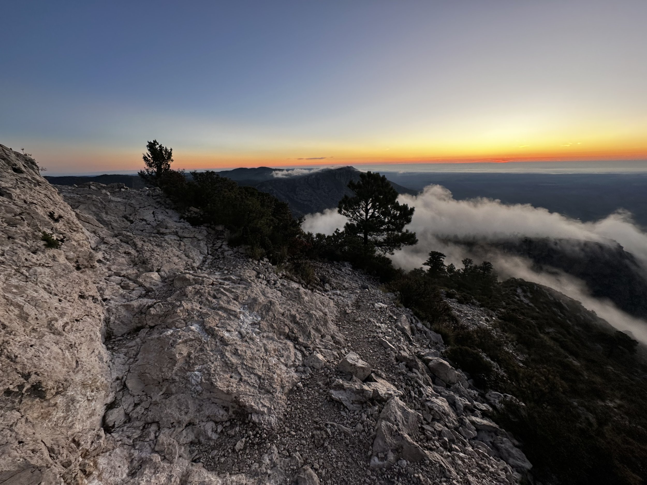
As the morning sky began to glow, surrounding ridges and hills became touched with alpenglow - their rocky crags and mountainous features seeming to radiate the warmest hues. Up ahead, we could faintly make out a shadow of trail, as it meandered up a steep, 8,116’ knob. By now, we could see low, undulating clouds rolling our way from the south of the mountain mass - glancing at each other, we still did not believe we would catch the sunrise from the true high point, but we certainly wanted to try.
As we passed a low, metal sign indicating the path to Guadalupe Peak Campground, I glanced across the low ridge and saw nothing indicative of a stealthy camping area, perhaps it was tucked out of sight, on the northern side of the mound. Swinging around another knob, the Guadalupe Peak Trail reaches a stunning lookout across an 8,120’ col: the steep, final climb with baren desert thousands of feet below as the backdrop.

NW views, toward Shumard Peak (8,615’)
Crossing the col on a narrow, wooden bridge, the bedrock below had nearly completely crumbled away. Across the col, the path re-enters treeline briefly before emerging for the final occurrence. From a distance, a white streak of trail can be seen slicing up the hillside. The aid of switchbacks may tack on extra mileage, but the pleasant grade, and solid footing of such a wide path are a welcome trade-off to a straight shot upslope, which would no doubt be plagued with worse erosion issues - the Guadalupe Peak Trail might have occasional rugged footing, but overall, the footpath is in stunning condition, showing evidence of frequent upkeep.

Summit monument atop the High Point of Texas
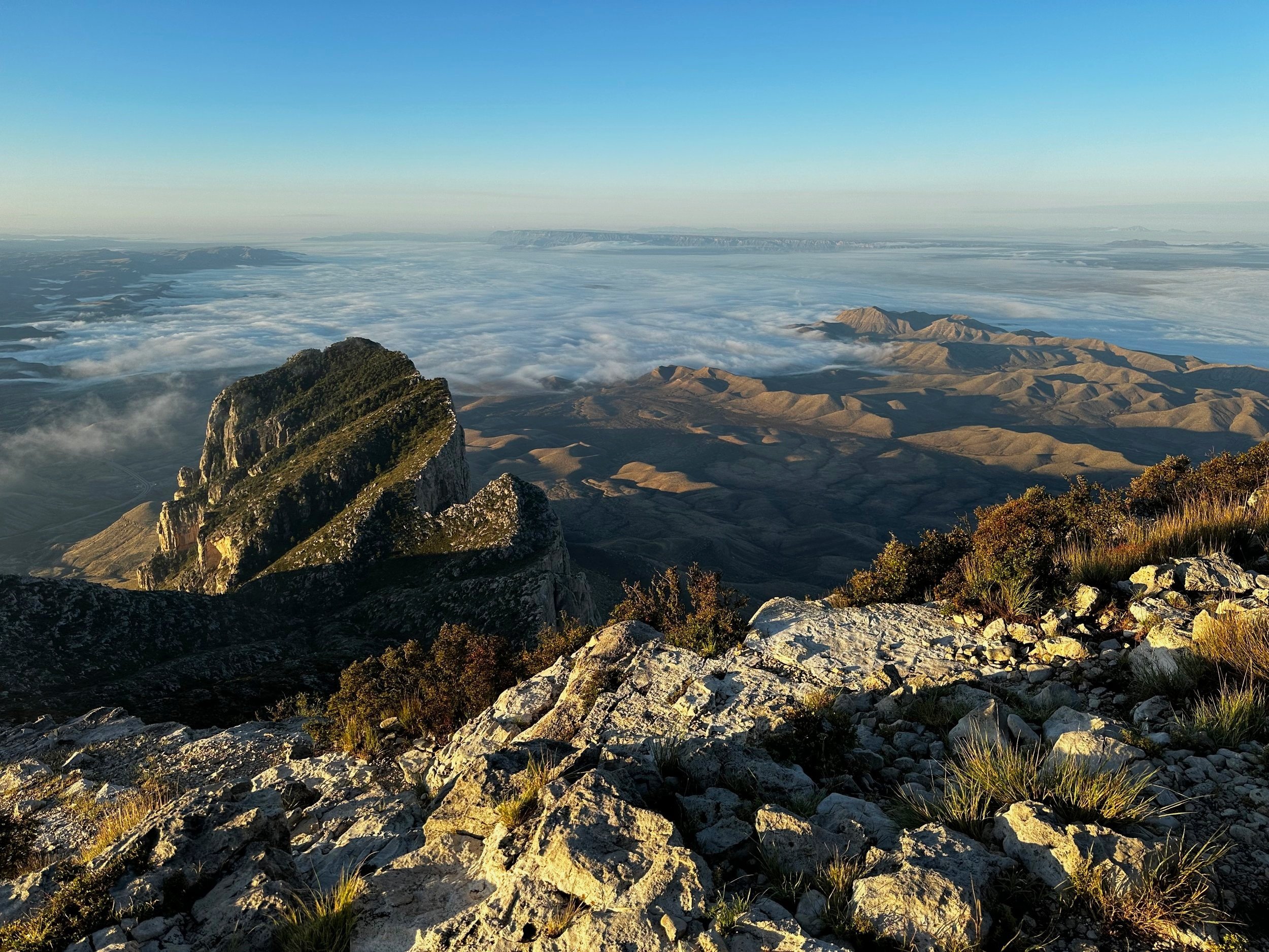
Reaching the final switchback, the high point was nearly in sight. We began treading on brilliant, white - quartz-like rock - much more crystalline in appearance than typical mountainous rock matrices. Waves of cotton candy cloud plumes floated by, hardly stalling on the ridgetops while swirling by. Luckily, a blanket of cloud remained far south, retaining a fine view out to the Chihuahuan Desert, three-thousand-feet below.
With one final climb along a rocky sidehill section, we scampered onto the summit area plateau just as the red-orange ball of sun crested above the horizon - with immaculate timing, we were welcomed by a warming, pink-orange glow. Taking several quiet moments to ourselves, eyes were shut to lessen the senses, and simply let the glow warm skin.

Alanna navigating the switchbacks
Thankfully, the clouds gave us a large berth, swinging far southward, around Guadalupe Peak, affording us excellent panoramas in all directions: due south, we feasted upon the 8th-highest peak in Texas: El Capitan, which rises like a cylinder of rock from the desert floor; southwesterly, the Patterson Hills crested about 5,000’ into the sky - their highest peak leaving over 3,500’ of thin air between it and where we stood. To the north, we observed the shoulder of Hunter Peak falling away thousands of feet, as it meets the plateau of desert landscape in the east.

A narrow bridge spans the precipitous col
Spinning around the summit, to absorb as many stunning vistas as possible during our brief stay, I followed a short spur path westward several rods before it terminated at a sheer drop off. A short, rugged descent brings hikers off the high point, to stand as if on a mighty ships prow, observing the mountainside drop away, to the tableland nearly 5,000’ below.
Back at the high point, I took a moment before departing to glance at the unique summit monument; it is an elongated pyramid. Placed in 1958, this stainless steel prism was erected and installed by American Airlines to commemorate the 100th anniversary of Butterfield Overland Mail, a stagecoach line which once passed due south of the Guadalupe Mountains.
Descending into Pine Spring Canyon
As others began summiting the state high point as well, we wished them a pleasant stay, and began back down the rugged, quartz-like pathway. Now, hiking in daylight, we could catch views in directions which were pitch black during our twilight ascent. As the morning sun began warming the surrounding rock, a memory from the previous evenings’ tale regarding the notorious “green rattlesnake” came to mind - this highly toxic creature is apparently unique to those hills, according to our hosts - we remained present, diligently checking trailside for any rustling, or movement.
The Texas mountain air warmed rather quickly while loosing altitude, yet we still encountered determined (very sweaty) hikers still ascending the steep pitch well into the mid-day heat. Letting gravity hasten our pace ever so slightly, we cruised as if on auto-pilot back downslope; leaning into the switchbacks, bouncing from boulder to rock slab - back to jagged boulders; thankfully the arid mountainscape accepted the grip from our trail runners very nicely.

Alanna, bringing some fancy footwork to Texas trails
Once back at the trailhead, to our surprise, the campground host duo could be seen - the couple sitting together on a park bench chatting with a Forest Ranger who had arrived to open several trail corridors which had been closed due to wildfire weeks prior; we never saw nor smelled smoke while in Texas, although the warnings were posted all over the National Park website - this is why the Welcome Center was not open, many facilities and trails in the area had been closed for well over a month.
We greeted our hosts, thanking them for the amicable accommodations, clean restroom facilities, as well as the accuracy of weather and trail reports, which were shared during their welcome spiel the night prior. Confirming that we did not encounter their eminent Green Rattler, to this, the duo chuckled, glancing our way to confess, “We forgot to tell you, it only comes out at night!” Assuming their claims to be bogus, we all laughed until it hurt, then they showed us how to peer down Pine Spring Canyon, spotting a face in the outline of a distant ridgecrest. The captivating duo twisted a fantastic tale of love and tragedy around the ridgeline depiction before it was eventually time to bid them farewell.

Eastward views from the lower Guadalupe Peak Trail
Wishing our campground hosts a lovely autumn, we returned to pack up the tentsite, before getting my first flat tire ever - on the side of an 80-mph highway with oil rig and pipeline pieces, as well as oil/gas-drilling equipment whizzing by, rocking me and the Subaru at each pass. Had we known our day had such additional adventure in store, we would have spent longer atop the highest point in the great state of Texas: Guadalupe Peak.
Overall stats for the day:
8.84-miles
5hr 21 minutes
3,100’ elevation gain
Guadalupe Peak - 8,749’

Summit monument with El Cap below