
The Long Trail: Jay + Big Jay Peaks
Year after year and one season to the next, commercials and radio ads try convince you that your season will not be complete until you ski their black diamond runs or mountain bike their wicked switchbacks and berms.
No doubt I find myself in northeast ski country but today the only attachments you’ll find on my feet are Tubbs snowshoes; I am here to romp along The Long Trail!
Located via a mere twenty minute drive from Journey’s End (the northern Long Trail terminus) this long distance hiking trail cuts directly over the high point of Jay Peak and continues through the state reaching its southern endpoint 274-miles later in the quaint village of North Adams, Massachusetts.
Anytime I step foot onto any section of the Vermont Long Trail I often find my mind cataloguing any signage, waterways or remarkable landmarks I might want to recall for when I get around to an actual end-to-end thru hike.
With two primary options of where a hiker could begin hiking the Jay Peaks I chose the more popular trail head located on Route 242. Arriving from the east, I dropped down onto the main road, passing the official parking areas for the ski resort and several windy miles later found the hiker lots located on the left bank of the road (south LT side).
Finding two lots plowed this morning, I chose the second for it appeared more hiker-friendly with a kiosk of maps and info. Beginning my hike at 8am on a weekend I found plenty of available space in their parking lots - when I arrived back from my hike later in the morning the lots were full of skiers and snowboarders, hikers only making up a small fraction of traffic.

Starting out on the Long Trail north; 2,220’
From where I parked, I could see the Long Trail across the road with a small hiker shelter just off into the woods where I stepped into a pair of Tubbs Flex Alp snowshoes which remained in place for the remainder of the trek out and back.
The trail departs Route 242 and instantly begins to side-step steeply up the shoulder of Jay and its surrounding mountainous bumps. Not far into the hike I had to check out the hut. Remaining just out of sight of any cars on the main road the hut was large enough to fit 6-10 hikers with backpacks if needed. Finding no signs indicating whether overnight camping was permitted or not, I would bet this wooden platform shelter gave refuge to many distance hikers over the years.
I tried to imagine this corridor of trail: green moss adorning either side, perhaps some old mans beard swaying in the gentle breeze, a few white, yellow and pink flowers popping up - all with a dark brown beaten path down the center; my slice of heaven.
Streaking the glades all around my ascent were trails from snowshoe bushwhackers and backcountry skiers plowing through fresh powder as they created their own lines down to the base of Jay.
Cutting through a beautiful forest dotted with gnarly old white birch the trail meanders through several small open cuts, probably unrecognizable once springtime ferns and shrubs pop-up, filling in the landscape with stalks, stems and buds of all shapes, sizes, colors and scents. No doubt a favorite resting place for birds and butterflies alike.
What began as a mild ascent up the side of the mountain turned into a gradually steeper grade until climbing nearly 1,500’ and topping out by bisecting the ski trails 1.5mi later.
First mistake was made by forgetting that the LT crosses the groomed ski trail and continued ascending along the broad rocks, however, the resort had yet to open due to low snow volumes; I simply snowshoed easily up a packed trail dodging boulders which peeked up through the snow - even long grasses poked through the thin cover and swayed in the gusts.
I always find roaming an empty ski resort rather eerie, especially at the summit, today I found the unoccupied restaurant vacant with chairs neatly turned up and stacked on the tables – very reminiscent of the then closed Saddleback ski resort in Sandy River, Maine recently.
Wind, wind and even more wind still. I ducked between buildings to fiddle with gear and batten down my GoreTex shell a bit better to protect from such high gusts. Any loose snow was instantly whipped into whirlwinds, encircling anytime I stepped into the open mountain air.
Glancing down the ridge it was not hard to spot my next objective, Big Jay Peak at 3,786’ - I had not even summited Jay Peak yet but was ready to exit the winds. Having read reports which instructed to “look for the repaired fence”, I checked maps over multiple sources and knew the spur trail for the bushwhack over the connecting ridge was just a slight distance down a ski trail. I pressed on into the wind as it screamed and slammed all around.

3,786’ Big Jay Peak
Bushwhacking Big Jay
Having descended southwest about 0.3mi I located what I thought was the famed fence. Perhaps this barrier had been broken in the past but it was in well working order (for a fence) today. Finding a sort of cattle-routing dual-fence allowing skiers and hikers to slip through and not have to go over or around, there was even a dual language (very close to the Canadian border) sign at the barrier indicating we would be departing the ski resort by trekking beyond.
Assuming I’d be following a bushwhack-type herd path across the ridge, I was pleasantly surprised to find a very easy to follow cut through the forest. Skiers had skinned over, packing a neat trail 6’ wide. Occasionally, drifted snow covered their tracks but with any sense of direction or idea of where this trail was supposed to go, it was plainly obvious, and if connecting ski tracks grew difficult there was a rainbow of surveyors tape to follow.
In just minutes I could glance back and see how far I had come, breaks in the tree canopy afforded views of the unmistakable pointy, bare rocks of Jay Peak in the distance.
Reaching the col the climbing resumed; at first gradual, the steep sections helped test the traction of the new snowshoes. I was having fun roaming on the Tubbs, feeling secure on packed powder while still in control as I neared the summit and stepped into multiple feet of powder.
Noticing several questionable spur trails swinging east I continued straight toward the behemoth reaching skyward in front of me; in the back of my mind recalled news articles read of skiers who decided to slash their own (illegal) ski trail down one of Big Jay’s faces – perhaps these were the illegal trails I had read about.
And like that my path just terminated.
Glancing around, I thought I saw where skiers had continued down the mountainside, I was certainly not here to follow their descent to wherever it led. Assuming that I had reached the summit I moseyed through the powder for a bit, looking for a high point in the snow.
Summit of Jay Peak; 3,862’
In some areas the branches had been snapped and small twigs broken off, to my intuition that indicated others had slammed their way through these trees. Wanting to find their destination, I followed, and glad that I had!
I found one glass jar hanging by a yellow cord which contained a yellowed pad of paper.
I began my day with the understanding this canister no longer existed, but here was the glass jar hanging from a green summit sign which eloquently read BIG JAY. I was now thrilled to have driven so far north and lugged myself all the way up these hills, what a joy!
10:18AM, January 25th, 2020 – I signed the summit register.
I sat there, kneeling in the snow, guarded momentarily from the gusting winds just overhead. I did it. Glancing through the register, I noticed it had been several weeks since anyone had signed in.
The return trek showed the strength of the wind by completely covering my recent snowshoe tracks but with a general idea of direction I bounced down those hills, up and over rolling topography, back through the col and (almost literally) ran into the first folks I saw all day.
Three skiers grunted their way up the bushwhack path toward me. We exchanged greetings as they inquired as to the state of trails ahead, the final skier in line exclaimed that this was her first day on skies and they were all skinning their way over to Big Jay, what an awesome first adventure.
Back at the ski trails I was properly greeted by winds once again as I climbed back to 3,800’. Riders were mere specks zooming around a minor peak within the resort. I was still alone on Jay, except for the one guy hunkered down under a flight of wooden stairs trying to get a cell signal on his phone, I don’t think he saw me waving.

3,862’ Jay Peak
The stairs leading to the actual summit of Jay were roped off so thus began another bushwhack - a 25’ light scramble up some boulders, some ice and snow and in short time I found myself standing atop the pinnacle.
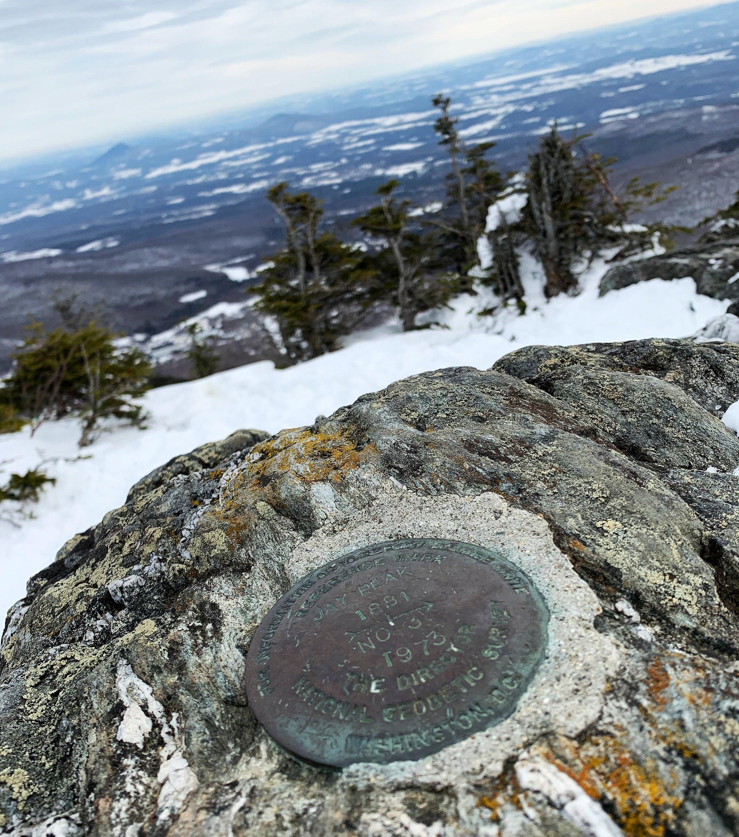
There were elegant stone benches and signs scribed with the names of both hikers and locals, complete with historical bits regarding the Long Trail. I stayed long enough to track down the USGS survey marker near the summit but due to the gusting winds my departure was hastened.
With a packed snow trail and no rocks or roots to contend with, the descent flew by and felt nearly effortless, performing a sort of ‘controlled fall’ down the mountainside until I inevitably began trail running, greeting dog walkers and other friendly forest go-ers near the trailhead.
Those without snowshoes left a sad trail of heel prints plunged into the softening afternoon snow, with snowshoes I did my best to disguise their imprints.
The sound of traffic grew louder and before long I saw the wooden structure once again.
My day was done, my mountain had been climbed.
Overall stats for the day:
6.15 miles
2hr 57 minutes
2,890′ elevation gain
Jay Peak - 3,858’
Big Jay Peak - 3,786’