
Stairway to Heaven via AT
Having hiked sections of the Appalachian Trail in each state it passes through, except the one in which we are visiting, of course I was excited to experience a section of NJ AT; as a New Jersey-native, Alanna had wanted to climb the Stairway to Heaven for years - now the opportunity had finally presented itself.
We opted for the extended version of the hike - beginning at County Route 517 or McAfee-Glenwood Road. Parking along the eastern side of the road we found a small kiosk offering local historical details of the Appalachian Trail including information on native flora and fauna which could be found during various times of the year.

Boardwalk through wetlands
Immediately, the footway departs the roadside and begins on a newer stretch of boardwalk; meandering through tall reeds and grasses, the flat wooden trail makes gentle switchbacks through a boggy wetland before making landfall temporarily. While an overall easy trek, the path is packed dirt with, at times, a moderate amount of large roots and rocks sticking through the earthen surface.
At 0.5-miles, the boardwalk resumes, quickly making a southerly swing which affords a wide-angle easterly view toward open water whence forth flows into the Pochuck Creek. Today, we observed Canadian geese with two of their young basking in the lazily flowing bog water.

Painted turtles sunbathing along the Pochuck Creek
Several paces beyond we came upon a bridge, under which scores of painted turtles of all sizes sunbathed on rocks and swam from here to there; trailside, we could see yellow dots streaking the open-forest understory - trout lilies mixed with tiny pink and white Spring Beauties.
From afar, hikers can get a glimpse of the 110’ Pochuck Suspension Bridge, which is reached at 0.7-miles from the trailhead and crosses the wide Pochuck Creek. The boardwalk continues for 0.2-miles further before the trail switches back to a relatively tidy surface of packed earth - which is surprisingly relatively devoid of roots and rocks - and begins meandering through the wooded hillside. Shortly into the woodland, several well-trampled, unmarked paths diverge - just be sure to continue following the white paint-blazes which denote the Appalachian Trail.

Pochuck Suspension Bridge
After a brief 0.4-mile roll through the wooded hillside, the pathway emerges onto the wide Canal Road, which is now primarily a bicycle path; our trail continues to the right for a short stretch before crossing another creek atop a foot bridge and veering back into the forest in a southeasterly direction.
Nearing the end of the woodland, the trail becomes a long boardwalk through a boggy section before terminating rail-side, along the Lehigh and Hudson River Railway tracks. The path crosses the tracks and enters active farmland on the far side; the accompanying signs asking hikers to please not approach the cows has become synonymous with thru-hikers along this length of New Jersey Appalachian Trail.

Soft treadway of the Appalachian Trail
While hiking along the boardwalk which spans the farmland, be sure to glance up ahead at the long ridge which is Wawayanda Mountain, the escarpment ledges of Pinwheel Vista can be seen from here as well. Reaching the edge of the pasture, a stepped stile is climbed which aids hikers over the wire fence; beyond which is a generally busy highway - Vernon Warwick Road.

Entering Heaven Hill Farmland with Wawayanda beyond
Crossing Vernon Warwick Road (Route 94), the pathway now cuts through a small parking area which is an appropriate trailhead for those who want a shorter hike, up to the lookout and back. A kiosk can be found with news and local agency contact information.
Beyond the powerlines the trail now passes through an impressive area of young white cedar, several minor herd paths diverge and meander in various directions. Reentering the woods along a wide old forest road, the path soon veers south/southwest to contour the base of Wawayanda Mountain and pass a low-angle boulderfield - a mass of tumbled rock and talus which once comprised the mountain-slope itself.

Approaching Wawayanda Mountain
Several massive boulders are passed, one of which resembles a small ships prow and is often a popular location for photographs as hikers scale the steep slab to sit atop its pinnacle. After following along the base of the mountain for 0.4-miles, the pathway abruptly begins to swing at a universal double-blaze, to ascend the steep, rocky slope itself.
Constructed in the early 1990’s, the pathway climbs by way of elegant stone staircases and in other areas atop the jumbled mass of boulders - all the while the pathway remains well-marked and given the high traffic along the footpath, easy to follow.

The Stairway to Heaven
The moderate grade switchbacks several times along its 800’ climb up to Pinwheel Vista, several minor lookouts (Annie’s Bluff being one to research) can be spotted trailside as well, none of which we visited today. Nearing the ridgeline, the trail begins to side-hill the mountainside while tracking in a northeasterly direction.
Underfoot, stone slab staircases, from which the trail earns its name, adorns the hillside and aids in traversing the steep grade. Upon reaching the crest of today’s climb, while still in the cover of hardwood forest, hikers are welcomed by a massive rock cairn - standing taller than most visitors. The tree it surrounds features blue blazes, markings which we would now continue to follow for several rods toward the lookout.
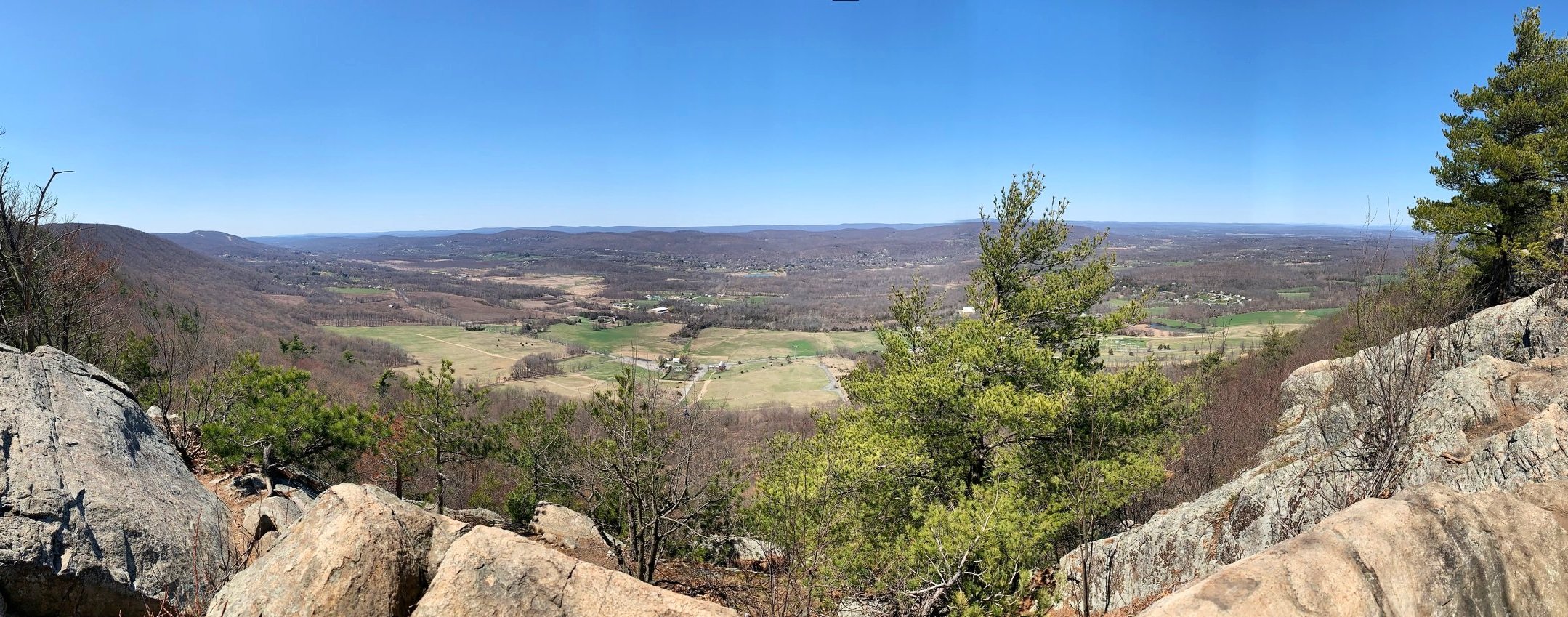
Northwesterly views from atop Pinwheel Vista
Jaws dropped as we traipsed out onto the bare ledge; several other hikers were perched nearby having lunch. We came out initially along the southern edge of the vista point but the ridgetop ledge stretches far to the north, and while it gradually downslopes westerly, can spaciously accommodate quite a crowd, albeit noisily and distracting from the beautiful scene stretched afront.
While Vernon Valley falls directly nearest and below the mountain, on a clear atmosphere day, the views stretch from the Kittatinny Mountains to the Shawangunks and Catskill Mountains of New York State. It has even been said that the 220’-tall stone obelisk atop the New Jersey High Point can be discerned from Pinwheel Vista.

After a short reprieve for snacks, refreshments and views, we followed our tracks back along the blue-trail to the gigantic cairn and began back down the hillside staircase; for an even longer stroll to the AT thru-hiker mailbox (trail registry notebook) and thenceforth the true high point of Wawayanda Mountain at 1,460’, follow the white-blazed AT left at the cairn to meet the ridgecrest in 0.1-miles.
As the time was nearing late-morning, we saw many more hikers trekking in as we departed; everyone seemingly enjoying themselves and pleasantly offering good wishes to one another - New Jersey is after all a very nice place to hike!
Overall stats for the day:
7.46-miles
3hr 34 minutes
1,493’ elevation gain