
Smarts Mtn: The Southside
After moving to New Hampshire, Smarts Mountain was the first big hill that lay just beyond my front door; in fact, the day I moved into the cabin I had one contract to sign alongside one late-90’s map waiting for me on the kitchen counter from the landlord. The map was primarily for his logging operations but to my adventurous eyes it was a treasure map containing both current and abandoned trails comprising the 50+ mile network of Smarts Mountain and Green Woodland areas.
A morning trail run often times consisted of a warm up 1-mile east along the old Lyme-Dorchester Highway to Cummins Pond, following the shoreline northerly along old logging roads to my secret path leading up the southeastern ridge of Smarts Mountain, which was clearly travelled more frequently by moose than humans in those days. I’d follow the AT along the summit ridge of the mountain and descent via Lambert Ridge to bask in open views toward the cabin.

Lambert Ridge Trailhead; 1,110’
I moved away from the area several years ago and occasionally make a return to visit my old friend, Smarts. Since then I’ve bushwhacked and ascended every direction, seeing the glorious mountain in all seasons, none proving better than the next.
The J-Trail swings south, following the Appalachian Trail from Mt Cube (2,864’) which lays to the north, traveling over exquisite trail work through stunning hardwood forest; the Daniel Doan trail is a lovely stroll through a mature birch corridor along Mousley Brook; one of my old trails (mentioned at the start of this writing) rising from Cummins Pond in Dorchester made its debut in 1937 as part of the 20-mile route comprised of DOC (Dartmouth Outing Club), AT (Appalachian Trail) and the Lyme-Dorchester Highway (now in Green Woodlands), linking Mt Cardigan (SE) to the summit of Smarts Mountain.
The latter was once the original AT route up to Smarts Mtn summit; ascending from the old Maskoma Lodge on the southwestern side of Cummins Pond (which is now within Green Woodlands) rising up the southeastern side of Smarts Mountain alongside Clough Brook (Clough Branch on some maps) by way of old logging and tractor roads. As one gains elevation the path, “gradually fades away”, as the 1987 AMC Mountain Guide book paints the picture so accurately.

Sunrise ascending Lambert Ridge; 1,940’
Smarts Mountain was listed as a 3,240’ mountain until the 1987 AMC guide book began notating the summit slightly shorter at 3,238’ which remains the current measurement. The mountain consists of two peaks which lay east and west - most sources claim that the western most summit stands higher while others state the opposite.
Departing from the Lambert Ridge Trailhead parking off Dorchester Road, I followed both snowshoe and bareboot post holes while the path quickly gains elevation, making use of several switchbacks as it meanders past cliff bands and large glacial erratics just off-trail.
Ascending initially through a beautiful northern hardwood forest, stunning southwesterly views are gained featuring the Dartmouth Skiway, Holts Ledge, North & South Moose Mtns and onward toward Hanover and the Connecticut River valley on a clear day, following several short scrambles up bare granite.
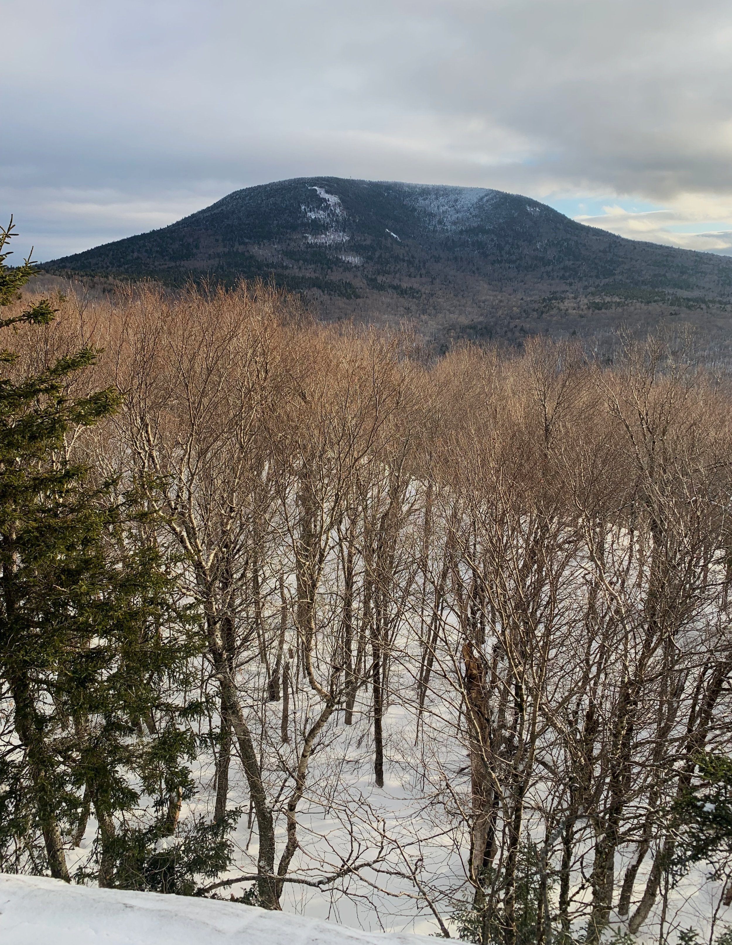
Smarts Mt from Lambert Ridge; 2,375’
As it was winter and I was travelling over 4-5” of consolidated, crusty powder I did not have the luxury of fully embracing the white and pink bands of quartzite which streak the bare granite ridges throughout the chain of mountains; the same quartzite bands have been found running from Moose Mountain to the south all the way up to Moosilauke up north.
After passing a nice ledgy spot with grand views to the east of both Reservoir and Cummins Ponds as well as Mt Cardigan just beyond, the trail dips back into more conifer cover, suggestions of the boreal forest which awaits just up ahead!
At around 2,380’ the crest of Lambert Ridge is found which has great views of the wide-topped mountain which appears still far away. Once the trail dives steeply off the ridge and back into the beech and maple forest, distance is covered quickly, although rather wet and boggy in areas.
While most soggy in early spring and summer, I was delighted to find a very frozen trail and soon reached the end of the snowshoe-post hole highway I had been following and began breaking my own trail through the AT corridor, consisting of a crust atop 4-5” of consolidated powder, this all struggled to hold my weight as well as gear on my back as each step was generally a conscious effort to not catch the nose of a snowshoe on the crust layer; I’ll take this over a muddy, wet trail anytime!
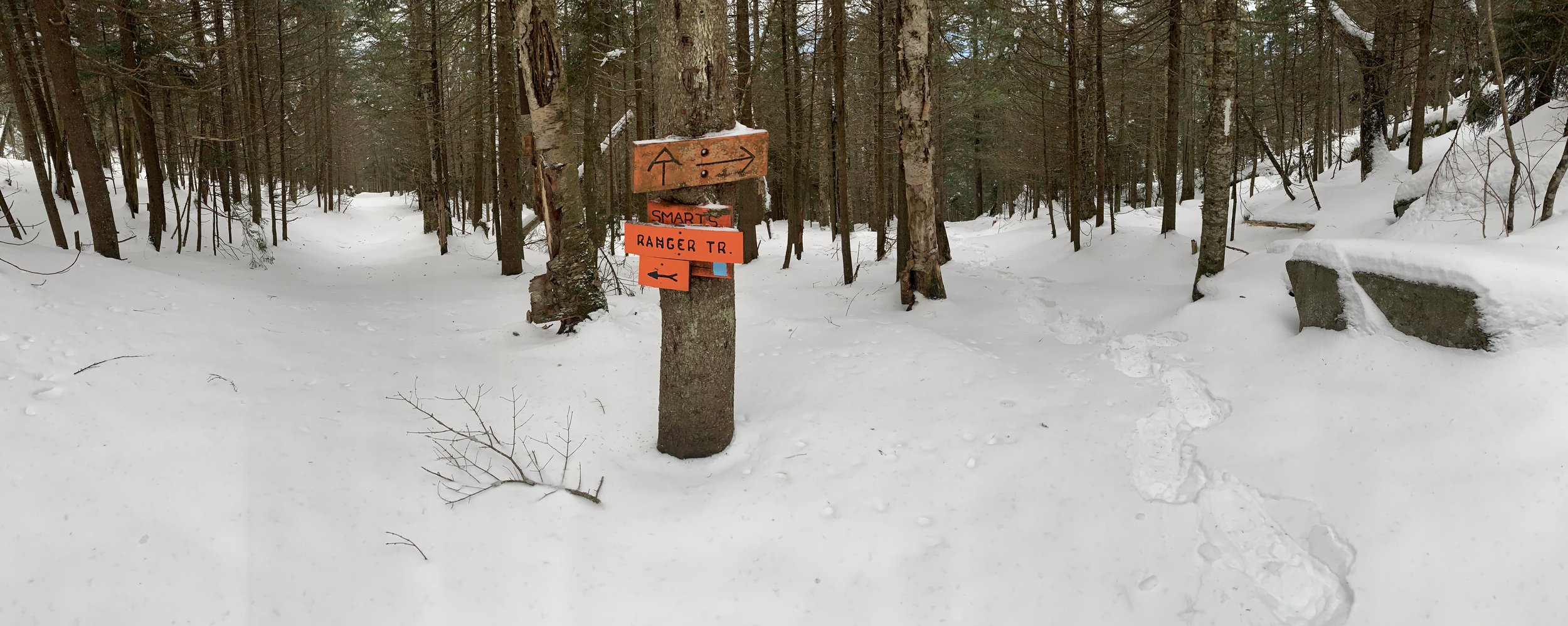
Ranger Trail - Lambert Ridge merge; 2,689’
Making use of pillow-topped rocks, a small brook and shallow ravine are crossed, the trail then grows steeper, climbing the southwestern shoulder of the mountain.
This section, while walking through incredible stands of spruce and fir, is notoriously wet; planks and logs remain in place to keep hikers feet dry and minimize erosion while in several places the wood has rotted away or collapsed, leaving the flat end of trail maintenance nails exposed by several inches, necessitating careful steps not only to navigate standing water.
Once again, another plus side to winter hiking this mountain - all of these puddles had a nice layer of snow covering and I never knew the water was underfoot until passing moose tracks broke the crust and exposed the hidden waterway.
Just prior to a hard right switchback, the Ranger Trail merges and two trails become one for the final 0.5-mile stretch to the summit. In warmer months the trail here becomes angled and slabby, aided by rock staircases to level off the footing as one climbs.
After the merge and right swing, hikers are helped by a large wooden staircase and rebar rungs which have been drilled into the rockface - today, these were not even visible under the depth of snow but I recognized the angled slope from previous ascents.
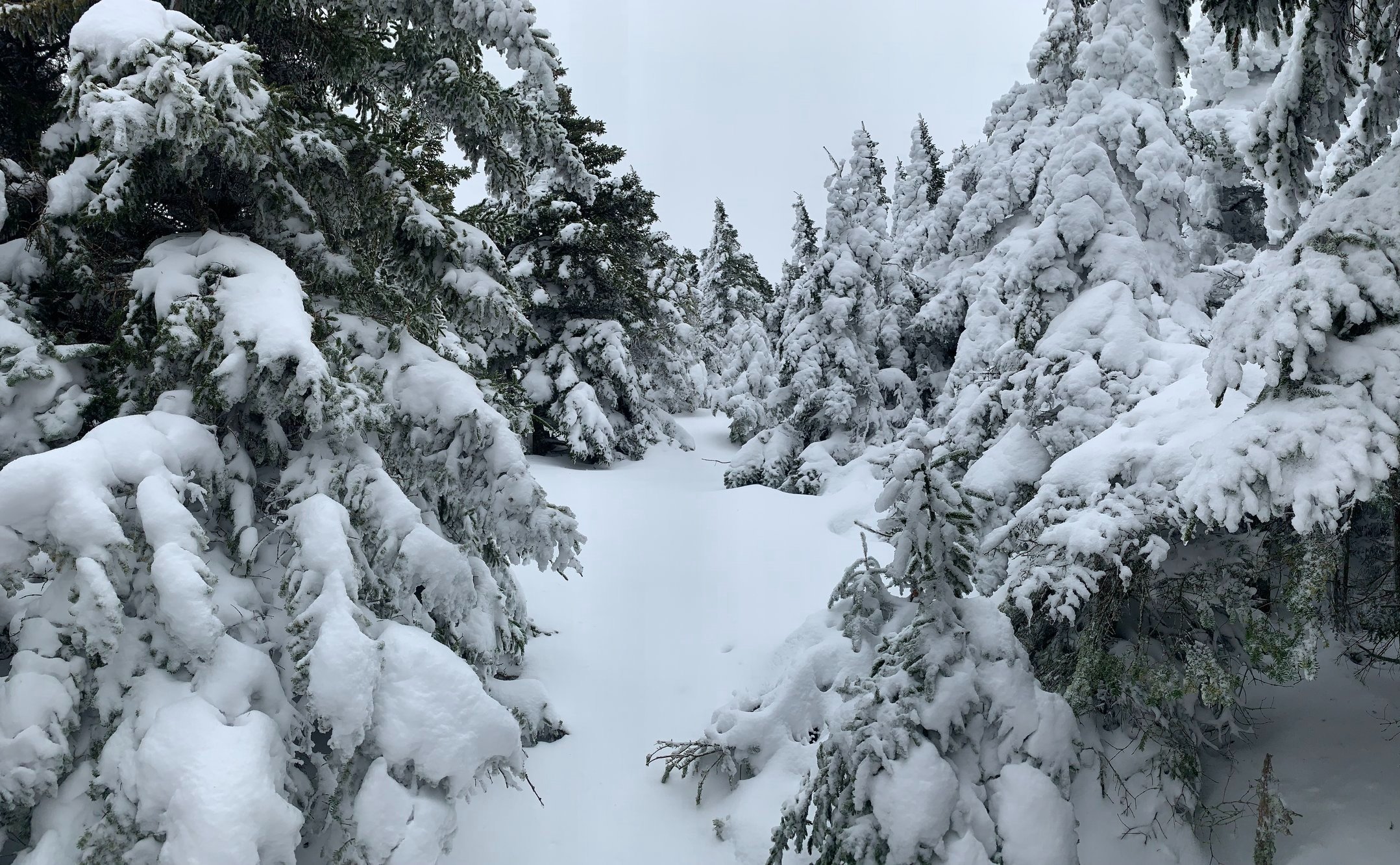
After the final switchback, around 3,100’, I was treated to a real alpine image - spruce and fir slathered with thick snow and rime which made each tree appear to have been dipped in thick, white icing. Taking steps in rhythm with my breath, I crept toward the summit like a puffing steam engine.
Typically in warmer weather I would hear voices of hikers out on the tent pad as I passed, the accompanying Privy spur trail arrived shortly after and with that I could see the grey steel structure towering through the trees on the left.
Nearing Smarts Mt summit, 3,100’
The fire tower which sits atop Smarts Mountain had been originally built 1939, vacated in 1973 and degraded slowly until being refurbished by DOC in 1994 and renovated yet again in 2016, the nearby ranger cabin also saw similar renovations around this time.
In most seasons the cabin to the 40’ fire tower is unlocked and affords excellent views in all directions - several windows can even be opened, but between these windows ajar and completely shattered single pane on one side, the floor of the cabin had been covered with a layer of frozen snow, of which weighed heavily on the fire tower door.
Taking several photographs of the surrounding land (and the fire tower itself which was artistically encrusted in a thick coating of rime ice), I looked at Cube to the north, the two ponds and Cardigan to the southeast, further south down the AT and toward Hanover was to my southwest just past the blazing white streaks of the Dartmouth Skiway and toward Lyme before reaching Vermont in the west, past the Connecticut River.
As the wind was picking up I gathered my gear which I had left at the base of the tower, hoping to be more nimble on the frosty tower steps, cut through the woods following blue blazes and found the cabin nearby. It was unlocked as usual so I signed in the guestbook register before grabbing a few gulps of hot tea.

Southern views from the fire tower steps
Now that the trail breaking was done, retracing my steps and descending back to the junction passed by very quickly. The encrusted surface providing all the traction I needed to make a quick descent over the rocky slopes beneath.
I had been down the Ranger Trail twice before and at the end of each hike I had promised myself that I would never make another lap up or down it; the first time was sopping wet and slick from fallen leaves, the second time featured enormous levels of running water under the snow which I punched through with each step - and the final crossing of Grant Brook was incredibly high.
As I made my ascent of Lambert Ridge earlier this morning I debated all the reasons to descend either trail; my mind was made up to retrace my broken out trail further west, but now something switched in my mind last minute as I traipsed back to the junction - I stepped onto a chute of virgin snow, The Ranger Trail.

Cabin atop Smarts Mt
I was rewarded immediately upon setting foot on the newer old AT, orange and black DOC swatches can still be found on some of the older trees, but the trail is now blazed blue and easier to follow now that trail maintenance has resumed over the past several years.
What are generally steep open rock slabs, often slick with wet leaves was was a complete joyride today, the layer of snow providing just enough grip to carry a fun amount of speed down the slope, as if flowing down a ski slope first run of the day.
The upper grade coming off of Smarts Mountain was dry and just a blast - clearly winter is the season to experience The Ranger Trail in all its’ glory! After several minor bends and swings in the trail I began following moose tracks which meandered side-to-side, the moose post holes actually punched through the crust to reveal the hidden water flowing underfoot.
Grant Brook became audible as the grade continued to taper, the trail inevitably grew wetter but was still easy to step into the woods, remaining on the fine snow layer. I feared getting the metal traction on the snowshoes wet as generally once wet they would gather snow underneath and become a nightmare to walk on, thankfully this was avoided today.
With 1.0-mile remaining I came upon my dreaded Grant Brook crossing - near white-water status last time I had to cross - I recalled the current tearing a trekking pole from my clutches and washing that downstream as I sunk a foot into the churning water. Not today - the rocks mid-stream were topped with a soft powdery snow pillow, facilitating an easy crossing and now standing directly in front of the old Ranger Garage.

Grant Brook crossing by the old Ranger garage
As I turned toward the final mile out I gave one farewell to Smarts poking up far in the distance, the last time it would be visible while hiking out. While wet and boggier than any trail encountered yet, good time was made descending the final section of woods road, segments of old corduroy road bed visible through gaps in the snowy surface.
Several of the trees still featured hangers from whence the old telephone from town to summit was once strung, thrilling to see bits of history living on into the modern age.
This is just a narrow glimpse into the network of lovely trails Smarts Mountain and the near by area has to offer, whichever trail a hiker decides to meander, they surely cannot go wrong. I do know that I will only ever venture onto the Ranger Trail well into winter as coasting down a hefty layer of snow was a blast. So good to get back onto old trails and see them shrouded in different seasons.
Overall stats of the day:
7.11-miles
3hr 55minutes
2,923’ elevation gain
Smarts Mountain - 3,238’