
North + Middle Sugarloaf
Often while driving home from the Presidential Range (south on US Rt 3N) I’ve wondered aloud, “what the heck are those cliffs?!”; no doubt forgetting to check my maps by the time I arrive back at home. Luckily, the short band of stubby ledges showed up on my plate almost accidentally the other day.
If pressed for time I’ll sometimes use the 52 With A View list to provide short-but-sweet hiking options, these hikes usually culminate with excellent summit views. While not really on a quest of checking off the peaks, the list has been good way of experiencing new areas of the White Mountains.
Finally, the day had come to explore North and Middle Sugarloaf; the higher of the Loaves occupies the near last (lowest elevation) position at #51, but more than makes up for this lack of height with the astounding panorama it has to offer for minimal energy expenditure.

Passing the Sugarloaf Campground on Zealand Road
Stretching northeasterly from Guyot, Hale, Zealand mountains, terminating at North Sugarloaf, these three granite knobs make up the northern bumps of The Little River Mountains located just south of the town of Twin Mountain, NH.
Once home to a booming logging industry, the area of Zealand Valley was scarred with massive forest fires from the operations in 1886 and 1903, leaving the Sugarloaf summits - as well as so many others in the area - baren.
Continuing north of Mount Hale (4,049’), the three Sugarloaves (North, Middle, South) can be found. While the northern two loaves have been popular hiking destinations for nearly a century and a half, “a deep depression and sheer cliff separate the second and third Loaves, and no trail exists”, as an early AMC Mountain Guide noted.

Along the Sugarloaf + Trestle Trails
While it is still winter (some may argue this fact with the recent 60° afternoon temperatures) here in the northeast, Zealand Road remains gated and covered with snow. Winter parking for Zealand Road access can be found 0.3-miles to the east on the northern side of US 302.
Immediately crossing the Ammonoosuc River, the snow-packed road ascends around a bend and soon the highway falls out of view, one finds themselves emersed in a peaceful forest once again. Beyond several snowmobile and ski trails, the road walk finally passes the two Sugarloaf Campgrounds and upon reaching 1.2-miles into the snowy road trek, comes upon the warm-weather parking lot and trailhead.
Departing Zealand Road just beyond the bridged crossing of Zealand River, the Sugarloaf and Trestle Trail coincide, contouring the southwestern edge of the river and passing a washout from 2011 Hurricane Irene.

Ascending Sugarloaf Trail
At about 0.2-miles along the river, the trails diverge; arriving on maps in 1987, the Trestle Trail continues straight while we veered left at the sign to continue following the much older Sugarloaf Trail.
Initially travelling through a spruce and evergreen corridor, the trail crosses a snowmobile/logging road before returning to the dense conifer canopy which gradually tapers into open hardwood. Several massive boulders, some of which have cracked, line the trail, making interesting caves and offering a unique photo op or water break.
The Sugarloaf Trail rises to the col, gradually at first, then becoming much steeper toward the top and making use of several switchbacks. Restricted views out to Mount Washington (6,288’) and the Presidential Range begin to appear through the trees to the east.

N/M Sugarloaf junction
At 2.0-miles into our hike, a T-intersection is reached where the trail swings left for 0.5-miles to reach Middle Sugarloaf or right for 0.3-miles to the view points on North Sugarloaf; unaware of which had better views we simply went to the North summit first, hoping to avoid a large crowd behind us.
In the 1940 AMC Mountain Guide (and up until the 1976 edition) the Baby Twins Trail (Baby Twins was an early name for the Sugarloaves) continued northwesterly from the col, descending along Tuttle Brook toward the town of Twin Mountain, this path was later renamed and was a continuation of the Sugarloaf Trail.
According to old maps and reports, it appears the old North Sugarloaf spur trail swung right to gain the summit of the northern hump, the current trail takes a clock-wise spin up through glorious groves of spruce before reaching a stunning, sheer drop-off and jaw-dropping view of the Presidential Range.
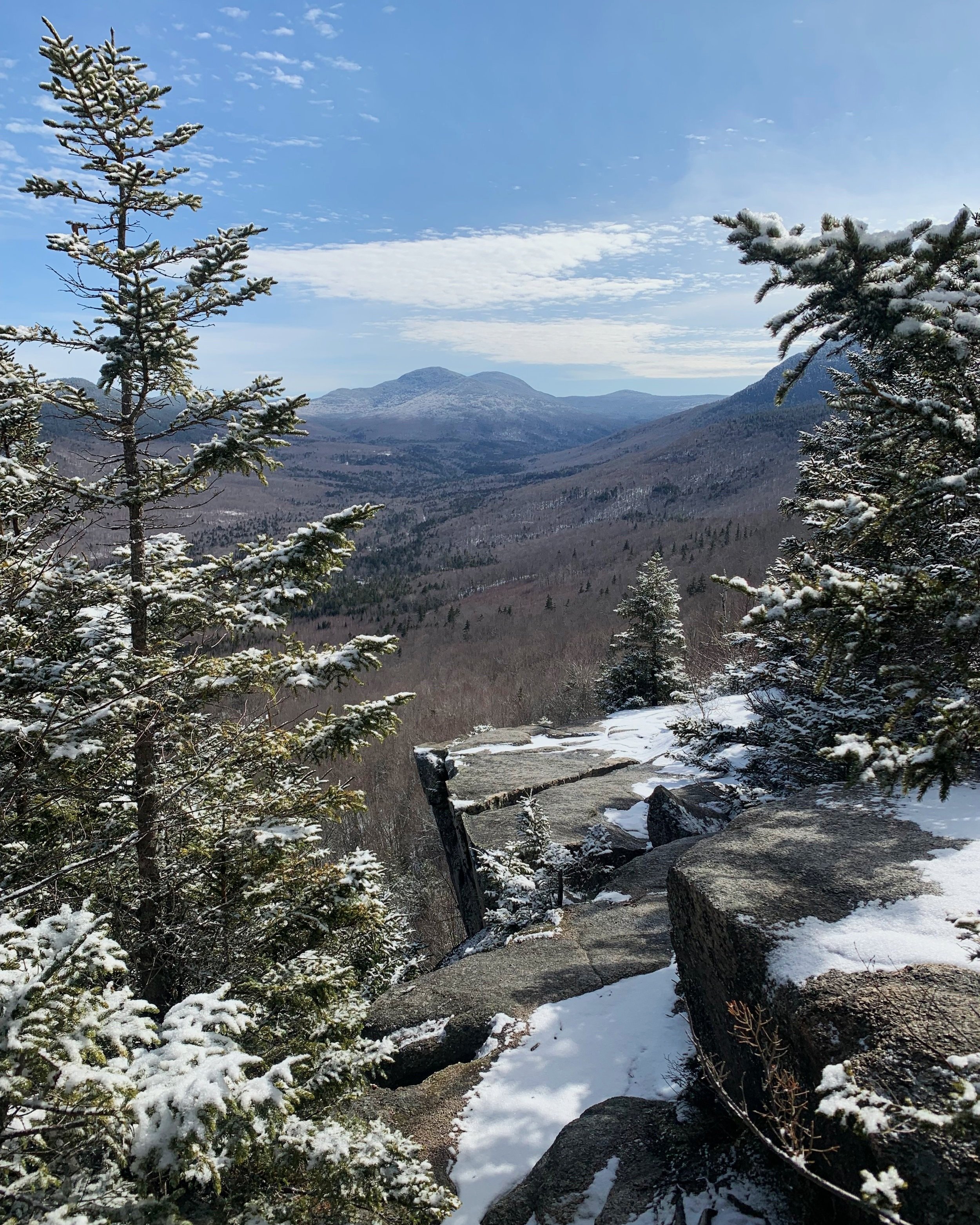
Ledgy cliffs of North Sugarloaf
Once topped out on the North Sugarloaf spur, another junction is reached which swings northwest toward a small private ledge with good views or continues south, toward the true summit of the mountain, rewarding with fantastic views south, toward the next destination.
Retracing our steps back toward the junction along the ridge, one passes a small smoky quartz quarry, which was unfortunately not visible today given the remaining snow in the hills, but affords a good reason for a warmer weather return, of course to revisit and roam some ledges as well. The USFS has posted a sign with details pertaining to mineral collecting at the junction of N/M Sugarloaves.
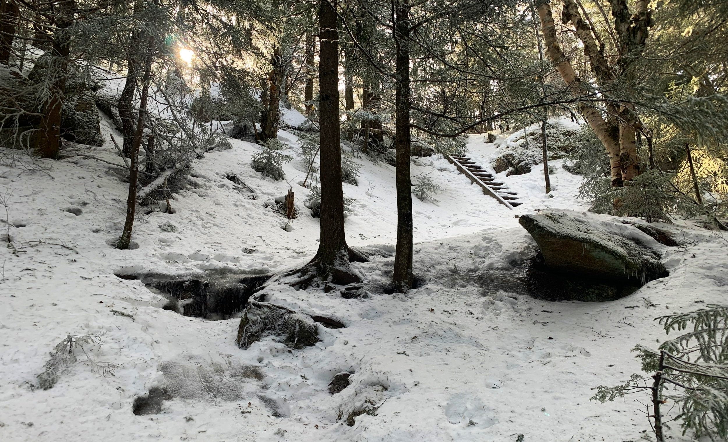
Ascending Middle Sugarloaf
The trail toward the Middle Loaf begins gradual but soon grows steep, utilizing several switchbacks as one ascends through a spruce and birch forest. Just prior to stepping onto the open summit rocks, hikers climb a short ladder - this is certainly one area I cannot wait to see what is buried underneath all the snow and ice.
Cresting onto the summit area the vistas stack up, the panorama grows into one of the finest the White Mountains have to offer. With the giants peeking up from all sides, often times the views are better from some of these lower peaks - this certainly being one of them!

Middle Sugarloaf summit pano
To the left, the Presidentials wore a blanket of white; Mount Hale and South Sugarloaf seemed to tower above our heads almost reaching out for some of our mid-hike snack; swinging westerly the slide-streaked Twins rose up, accentuated by Peak-Above-The-Nubble (3,813’).
With the summit to ourselves, we watched crows riding the wind currents and looked for moose in the boggy branches below. Interestingly, there are also several erratics deposited atop the bare summit which make good photo opportunities. I roamed down the main-face ledges as far as I felt safe in this winter environment, scoping out what would be popular rock climbing routes in other seasons.

Zealand River
I could not believe how vast this open summit was and that I had never been here, I’ve seen so many folks turning off Zealand Road enroute to the Sugarloaves but with the bigger rock piles nearby, never gave them any thought. While I will always love my high peaks, its amazing to see how tastes change as one grows older, chasing the other summits now to get away from those crowded, sought after 48.
Overall stats for the day:
5.96-miles
3hr 12minutes
1,719’ elevation gain
North Sugarloaf - 2,310’
Middle Sugarloaf - 2,539’