
Mt Chocorua via Champney Falls
Having trekked along most trails to summit this open granite mound, which claims the spot for most photographed and painted mountain of the White Mountains, what keeps drawing me back to its northern aspect? Perhaps the perk of having a waterfall mid-ascent, or the jaw-dropping northerly vistas that beckon a reprieve from climbing, a plunge into unique spruce just below the craggy summit rocks? Whatever each hiker is in search for, they are sure to find it somewhere along the Champney Falls Trail while trekking to the 3,490’ bare, rocky summit of Mount Chocorua.
Located just off the Kancamagus Highway (US Rt 112) about 10-miles west of Conway, NH, the trailhead parking lot fits many cars (usually filling to capacity on nice-weather days) and offers vault toilets before hitting the trail. But be prepared to pay a $5 parking fee or display a National Park Pass.
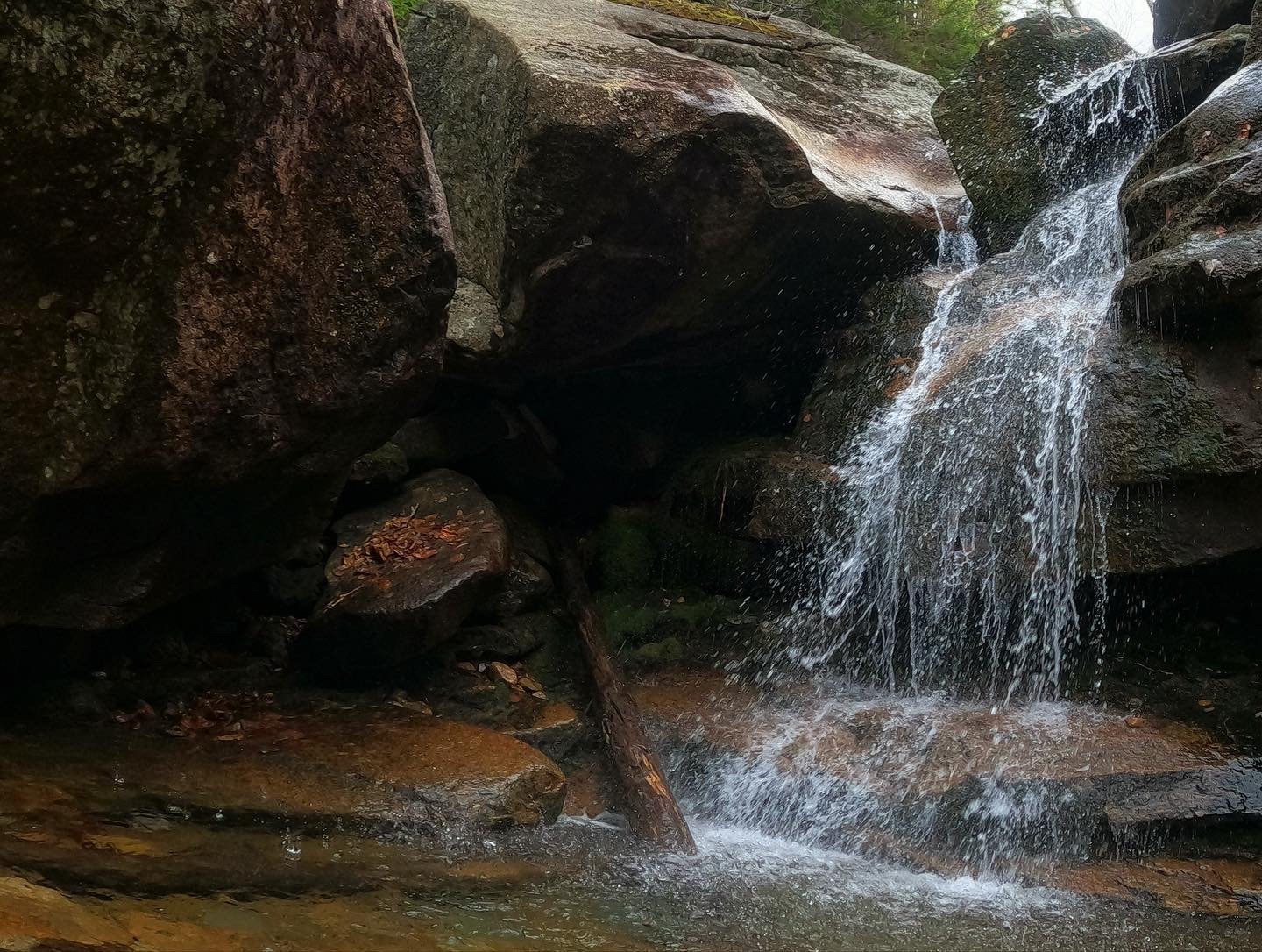
Champney Falls
The trail crosses Twin Brook nearly immediately after leaving the parking area, which can be avoided in times of high water by detouring down the shoulder of the Highway and cutting south to rejoin the path by way of old lumber road.
Following these old logging roads, the Champney Falls Trail proceeds left at a gentle grade while the Bolles Trail veers to the right to meet up with the Bee Line Trail further south, between Mts Paugus and Chocorua. In more recent years our trail adopted old sections of “alternate routes'“, which aid in avoiding the four original crossings of Champney Brook along the ascent.

Along Champney Falls
Originally built by Professor J.S. Pray, the Champney Falls Trail followed logging roads to Champney Falls, beyond the falls was obliterated by forest fire and relocated for the AMC by a local forest ranger. The Chocorua Mountain Club began maintenance on the trail briefly until the US Forest Service took it over as a horse trail in which to access the 1927 fire lookout station on Middle Sister.
All the while the audible brook slowly falls from sight as hikers ascend the north-facing ravine; at 1.3-miles the path diverges, a left here guides hikers to Champney and Pitcher Falls, a destination we were saving for our descent; conveniently, while taking hikers to cascades it forms a nice loop, no backtracking required.

Enroute to the open summit
While the forest colors are enhanced in autumn by a glow of changing leaves, footing along the Champney Falls Trail can be made slick from a carpet of hardwood leaves atop the rocky footway, often wet beneath from water trickling from the uphill side of the path.
At ~2,580’ we reach a small landing where views to the north can be had, especially once canopy leaves drop; “just beyond, the steep trail has been replaced by an elaborately constructed horse trail, which ascends the slope by a series of zig zags.”, notes early AMC White Mountain Guide books; another addition to the 1924 USFS trail adoption.

Mild scramble up northern ridge
The once well graded path has become rocky with loose, often wet footing; elevation is gained quickly but rather gradually and on busy days it is possible to hear other hikers further up or down the northern wall, along the network of switchbacks.
Just prior to the trail diverging for Middle Sister and other points to the northeast, a patch of spruce is entered which was sparred from the old fire. Reaching the saddle between the First Sister and Chocorua’s northern knob, a view south toward Chocorua and the coming climb can be found. At the end of the Champney Falls Trail we bear right, continuing onto the Piper Trail which will take us the remaining distance to the summit through a beautiful evergreen forest over exposed bare rock softened by a surrounding bed of fallen conifer needles, before leaving tree line.
Ascending the northern ridge
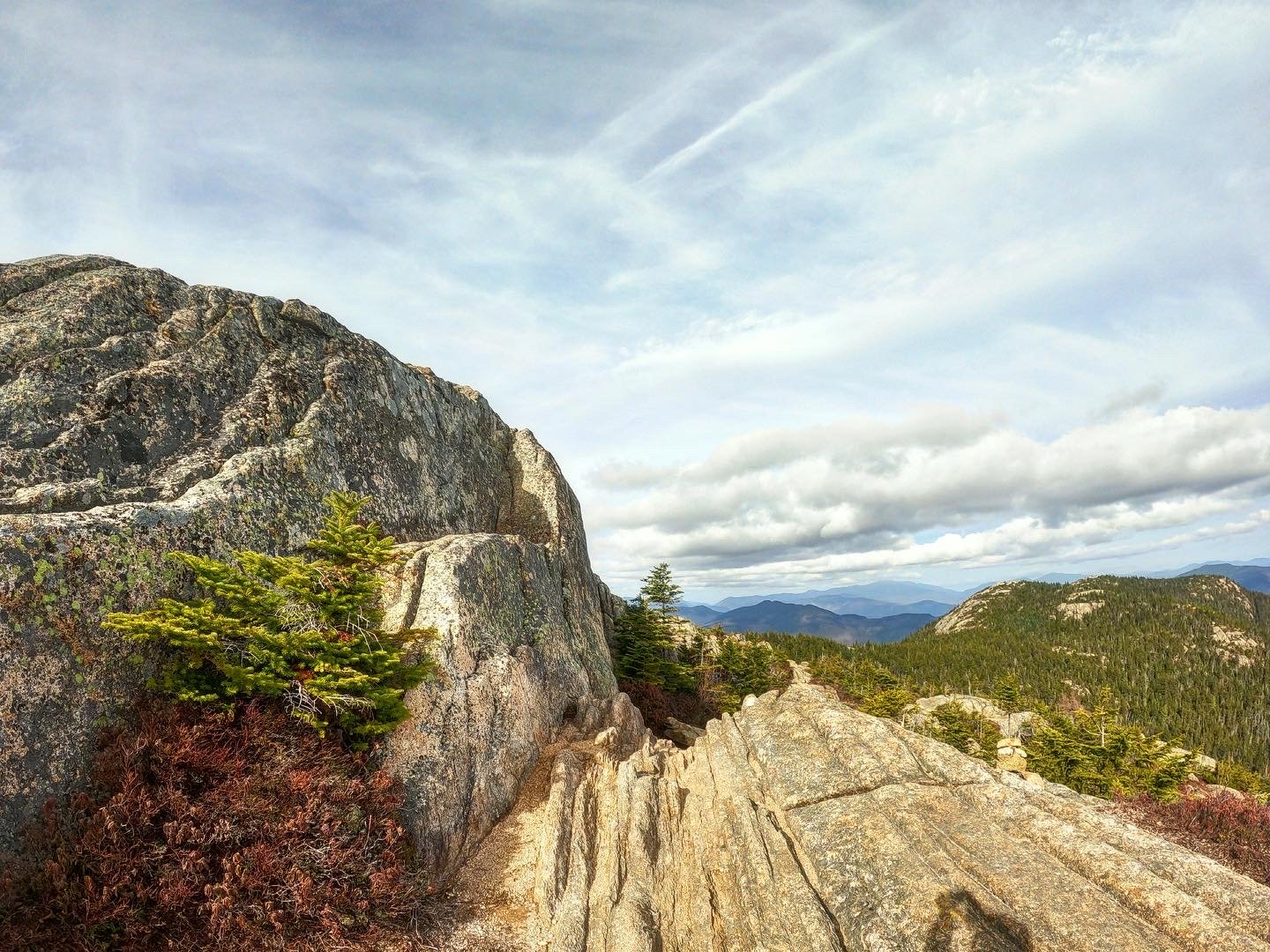
Also known as the bad-weather trail, the West Side Trail was once a horse trail which ascended at a gentler grade, skirting the west side of the summit cone. Along the Piper Trail we soon emerge from the forest to stunning views to the neighboring Three Sisters, while just behind, the towering mass of jumbled, light-colored rock comprising Mount Chocorua is visible.
The path follows faded yellow blazes and occasional cairns while in the warmer seasons (when free of snow) it may be possible to just simply follow the surface of foot-traffic worn granite.
Along the western face of the mountain, our path now meets up with The Liberty Trail which will coincide as one continuing toward the summit by way of a narrow chute which becomes steep, necessitating care with hand and foot placement, especially on the descent.

The rock plateaus out and offers various locations for climbers to spread out for a break and take in the views to the west, south and east, the better views north-facing are had from the true summit which is to the left upon topping out of the small chute; a short scramble brings hikers to the USGS Survey Benchmark and iron rebar left over from the survey station at 3,490’; be sure to trek only on bare rock while up above tree line, protecting the fragile ecosystem at higher elevation atop the mountain.
Staying just long enough to take in the glorious sights, we departed in search of more remote patches of bare rock as today’s beautiful weather brought hoards of hikers to Chocorua’s summit. Returning just the way we came, I spied several steep, craggy areas along the northern summit cone that begged to be climbed and scrambled upon.
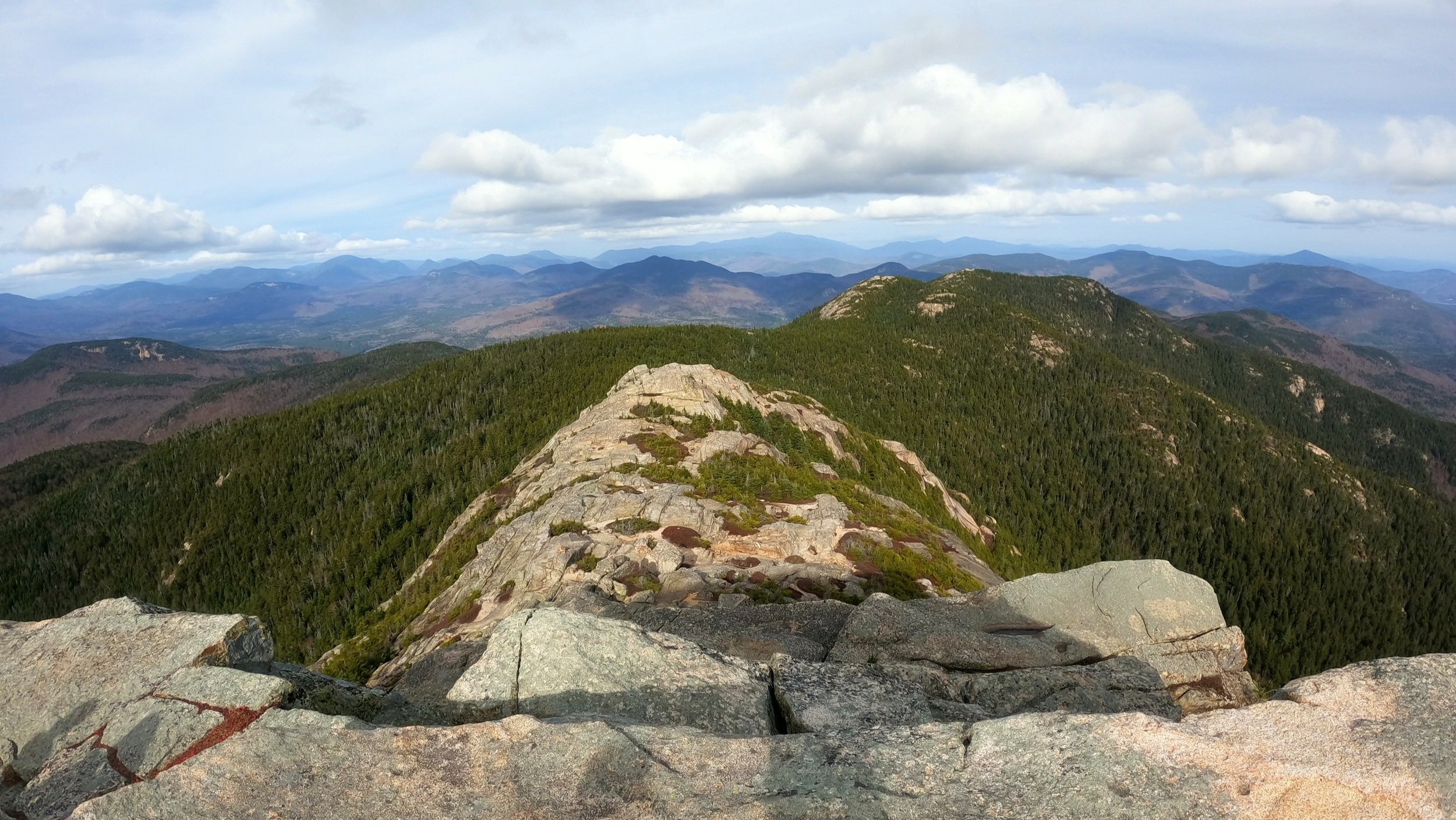
North views with the Sisters nearby
Back along the descent, we veered off to the right along the Chamney Falls Loop Trail; stopping to view a spectacular Champney Falls, we dreamt of the falls in full on Spring melt. Continuing down a path of beautifully constructed stone steps, the show was not over yet.
Crossing the low Champney Brook by way of rock-tops we carefully made our way over to the narrow cleft where Pitcher Falls can be viewed; the last time I had visited either of these falls were on snowshoes, Pitcher Falls is a popular ice climbing destination and at that time could understand why, with ice building up nearly wall-to-wall, a truly remarkable and unique White Mountain sight!

Narrow cleft of Pitcher Falls
A gradual ascent brings hikers back to the main trail following the 0.3-mile sight-seeing detour and onto the easy trek back to the trail over familiar logging roads.
While the Champney Falls Trail remains a favorite, it certainly pays to check out some of the other paths; I ran a trail race at Chocorua years ago which began through several low-elevation Preserves affording brilliant views of the rocky spire, ascended via the southwestern Brook Trail, climbing steep ledges toward the top, cresting over the summit to descend via the Hammond Trail thus creating a beautifully scenic and adventurous 14.5-mile loop.
Whichever route entices you, be sure to visit during good weather as the summit does not offer much in the way of escape from the elements - and of course, these views are some of the best in the White Mountains!
Overall stats for the day:
7.44-miles
3hr 44 minutes
2,812’ elevation gain
Mount Chocorua - 3,490’

USGS bench mark disc atop Mt Chocorua