
Mount Thielsen
“The lightning rod of the Cascades”, aptly describes Mount Thielsen, and with one glimpse of the craggy dagger of a summit, it becomes plainly obvious how this mountain has received this epithet; even more so if standing atop its 9,182’ pinnacle, one can witness up close the remnants of melted, glassy rock which streaks Thielsen’s tallest boulders.

Mt Thielsen from the west
It had been several seasons since I was parked at the trailhead, looking up at the horn shroud in a layer of hoar frost; that day I made the call to bail on Mount Thielsen when the coming weather showed perfection for Mount Shasta, toward the south. Time had passed yet I never forgot about Mount Thielsen, it is a sight unlike much else to be found in the Cascade mountains.
Mount Thielsen is a volcano which experts tell us has collapsed and since been run over and its flanks honed several times by glaciers - all I know is that, just by the sight of this mountain, whether near or far, this fella means business and is ready to supply climbers with a most satisfying day of scrambling - all the way up to several Class IV maneuvers (5.1 rated moves exist on the 50’ rock pinnacle as well) nearing the top of the pinnacle.

Mount Thielsen Trail
Conveniently, Alanna and I were passing through town and had a campsite for several nights at the Diamond Lake Campground four miles from the trailhead. Long before sunrise, we awoke to our morning routine of coffee and putting final touches on our packs and gear. Just as the new day began illuminating the distant horizon, we hopped into the Subaru for perhaps our shortest commute to the trail yet.
At 6:45am, we joined three other vehicles in the lot and with our National Recreation pass showing, gave a “good morning” to the iron ranger who worked to collect a modest $5 fee per car to use the trailhead parking lot. Conveniently, there is a single vault toilet at the trailhead, as well as several fire rings (legality is undetermined) dispersed around the lot from previous campers.

Today’s objective rises above the canopy
Hikers can expect a very casual grade during the initial mile on the Mount Thielsen Trail (#1456), consistently gaining ~500’ as many lichen-draped conifers are passed. Despite colossal wind damage in the forest, the trail remains in immaculate condition, well-graded and well-drained as the dirt path meanders into the forest and away from the sound of vehicles zooming along Route 138 in the west.
Shortly after the Spruce Ridge Trail departs northbound, a wooden plaque indicates the entrance into the Mount Thielsen Wilderness (Umpqua National Forest). As one continues to ascend, occasional glimpses through the trees afford a stunning westwardly lookout toward Mount Bailey on the far side of Diamond Lake; likewise, fragments of our objective become visible through the understory toward the east as well. As one grows ultimately closer to the narrow horn, it seems almost incomprehensible that we can safely scale such a slim dagger of rock. Anticipation grows with each forward step toward the feature.

Mount Thielsen, west facing slopes
At 1.9-miles, the Mount Thielsen Trail makes an abrupt swing around the western ridgeline. Through a sea of pink and purple wildflowers, we continued trekking into the sun; for much of the morning we had the low-angle morning sunshine to warm us up, but from where we stood at this point, the spire blocked the sun but cast beams of crepuscular rays in our direction.
As we hit 6,800’ and kept on trekking, the shape of the western ridge becomes increasingly pronounced and the surrounding landscape becomes more rocky, as the trail itself remains a single track corridor of dirt and small gravel. Upon reaching the Pacific Crest Trail junction, perhaps the finest view of Mount Thielsen yet can be enjoyed. The climbers route becomes visible (and appears much less daunting up close!) as does a rainbow of streaks down the western flank of talus and scree - such a magnificent sight to behold!

Pumice formations at 8,650’
From where we were perched at 7,330’, we could still see lingering snow high upon the mountain, where the talus met solid rock. The wrinkles in once molten rock appeared twisted - as if reminiscent of grain pattern in a wooden burl. Despite being only 0.75-mile distant from the jagged spire, wrapping my head around the scale of such a rock tower was proving to be an impossibility at that moment.

South ridge w/ Mt Scott + Crater Lake rim
Footing became progressively loose as we climbed, occasionally the pathway would venture northward, toward the top of the ridgeline to offer a unique and colorful glimpse at the mountains’ flanks; as treeline is left behind, more stunning views are rewarded for the climb thus far. Switchbacks in the loose trail attempt to aid in ascent, providing a lower grade for (hopefully) fewer rocks to slide out; but as with any scree-field, it is not long before two-steps forward result in one-step slid back downslope.
Ascending this loose terrain is hardly the issue, the tricky part comes upon trying to descend the loose rock, as one step downslope is placed, all small rocks underfoot proceed to roll and slide out - trekking poles may help in this situation, but would be come terribly cumbersome higher up, while scrambling the bare rock pinnacle.

Scree-field turned to vertical plates of rock
At around 8,650’, I was able to pause momentarily to peruse my surroundings, the pumice blocks rose up like a scene out of the Moab. The loose scree which had been clambered up began transitioning to solid rock underfoot. Massive plates of cream colored rock stuck up, while a beautiful scene for sure, the change in rock was just what I did not know I needed, the grip was outstanding and handholds came at a dime a dozen, now I was able to make good forward progress up the steep mountainside.
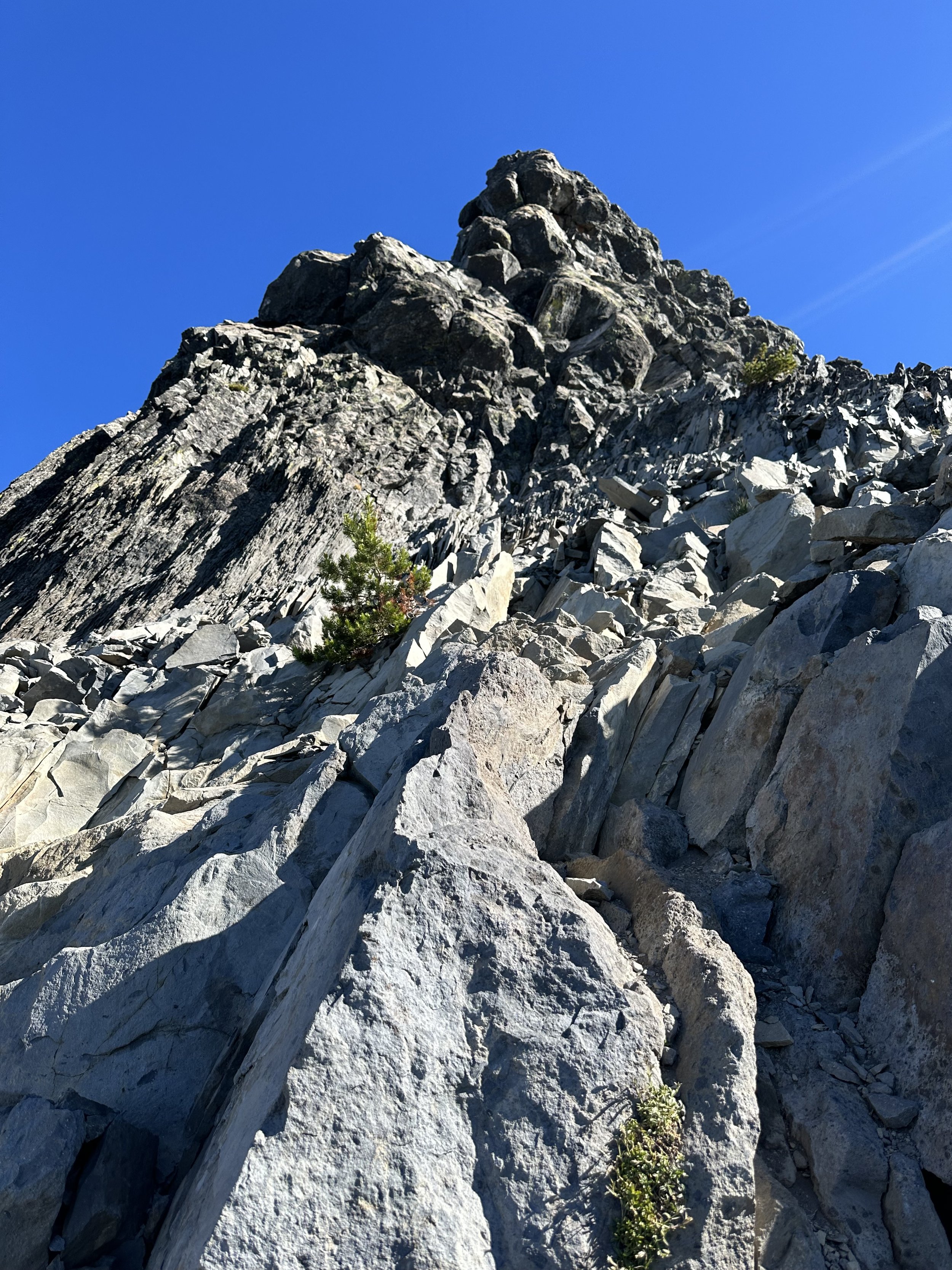
Looking up the final spire of Mt Thielsen
While searching for secure hand and foot placement, I observed globs and mounds of peculiar rock, not as anything I had found thus far in the climb - this amalgamation of rock and reddish-hued cement substrate looked to be straight off the beautiful slopes of Mount Hood.
While keeping an eye on the topography, the route angled me into a chute where I could hear the Foo Fighters echoing off the rocks just up ahead. Yelling to my new friends higher up to alert them to my presence, the last thing I wanted was to be beneath rockfall. Hand over hand, I made it to their place on the rock in seemingly no time at all, and waited as The Foo Fighters continued to play. I grew antsy at their lack of interest or capability in moving either up or down the mountain.
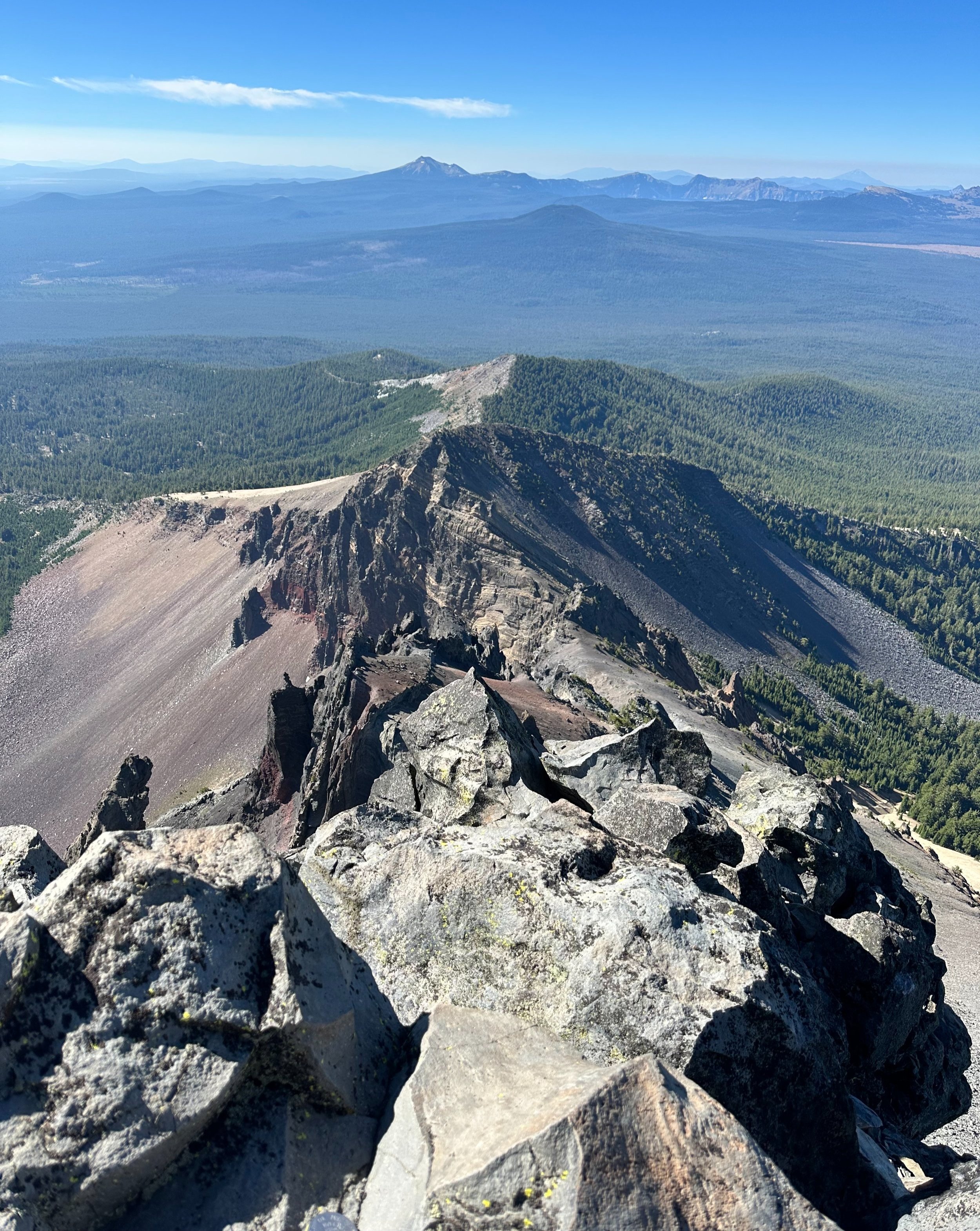
Peering down the south ridge toward Crater Lake
After making small talk with an older gentleman who led on to be their guide, (he pointed out how we could see into Crater Lake from up there), he stated “there is plenty of rock here, loads of routes to take up.. be our guest!” Say no more - and with those kind words I took off, up a pedestal to a few good hand and foot placements. The two young men higher up, whom I had not wanted to crowd, exclaimed, “whoa, you’re flying up this stuff!” The first in line actually said he was waiting for me to show him the route up the lower section of Class 4 climbing.
While it certainly did seem a voluptuous amount of consequence await anyone who might slip on this sort of terrain, with a solid handhold, good foot placement and really slowing down to ensure you’re placements are rock solid, the climbing was really nothing other than extremely pleasurable. There was one tight squeeze to fit through in order to access other placements - but as the guide of the other group noted - there are many routes in which to scale this upper section.

Atop 9,182’ Mount Thielsen
Near vertical pulling and pushing of oneself soon tapered into an easy scramble up toppled boulders - the summit! So aptly put by a climber online who compared the spaciousness of Mount Thielsen’s summit to that of a closet. It sure is a precipitous point up there, take a look over the eastern side of the spire for a real dizzying view into thin air.
As The Foo Fighters continued to play behind me, now cresting up onto the summit landing as well, I took a few photographs, had a good last look around and let the other hikers shimmy past. I wished them all a good day and safe return as one of the gentleman remarked that Mt Thielsen had made an outstanding first climb - say what!?!

Petrological streaks in the mountainside
In a quiet state, unable to comprehend that I had just stood atop that sharp spire of a mountaintop. I made my return trek down as safely as possible, noticing that several switchbacking tracks downslope continued straight southwardly as I needed to follow the western ridge southwestwardly. With all corrections made to my trajectory, I happily also noticed that the scree paths which I now followed were much more secure - not great, but better than it had been.
Once again, the descent of the scree-field was oftentimes more harrowing than scrambling up the steep horn; while I had thought I brought the appropriate technique for skating atop such loose rock, as it turns out I was destined for a few short, quick glissades that day.

Survey marker atop Mt Thielsen
From the PCT junction, 4-miles back to the trailhead parking lot, we found the Mount Thielsen Trail a slice of heaven on which to run and jog, the sun shone just bright enough while never oppressive; bees lofted to find their treasure amongst the wildflowers. What a gorgeous day to find oneself scaling the iconic Mount Thielsen - I’ll certainly never grow tired of seeing the reaction from folks when they see the size and shape of the old, extinct volcano shard.
Overall stats for the day:
9.54-miles
5hr 51 minutes
3,766’ elevation gain
Mount Thielsen - 9,182’

Mt Thielsen taking shape on the Coros topo maps