
East Kineo Mtn + Black Hill
Sleep, coffee, run, climb, bushwhack, climb, run, climb, run.
That’s a pretty ideal kind of day for me, I’d say. At least, that’s how today went and I rather enjoyed it. I’ve been saving some lower-elevation peaks for just this kind of weather, shoulder season - or mud season; when the higher peaks of the White Mountains are plagued with rotten snow and annoying post holes, I’ve grown fond of the lesser summits especially around this time of the year as they tend to dry out sooner than their higher neighbors.
With yesterday’s snow survey mission to 2,227’ a success in my book, I thought now would be a decent opportunity to visit a few more local peaks which also lay just under 3,000’ above sea level.

Three Ponds Trailhead
Ever since snowshoe bushwhacking and finding that incredibly enjoyable mixed conifer forest over on the 3,318’ summit of Mount Kineo, I was drawn to the notion of making my return to check out the forest on the eastern side of the ridge and bushwhacking to the 2,981’ high point of East Kineo mountain.
While I assumed the Hubbard Brook Trail on the northern side of the ridge was probably not dry enough for an enjoyable ramble, I had scoped out and made plans to begin my trek from the south, beginning at the Three Ponds Trailhead near Stinson Lake.
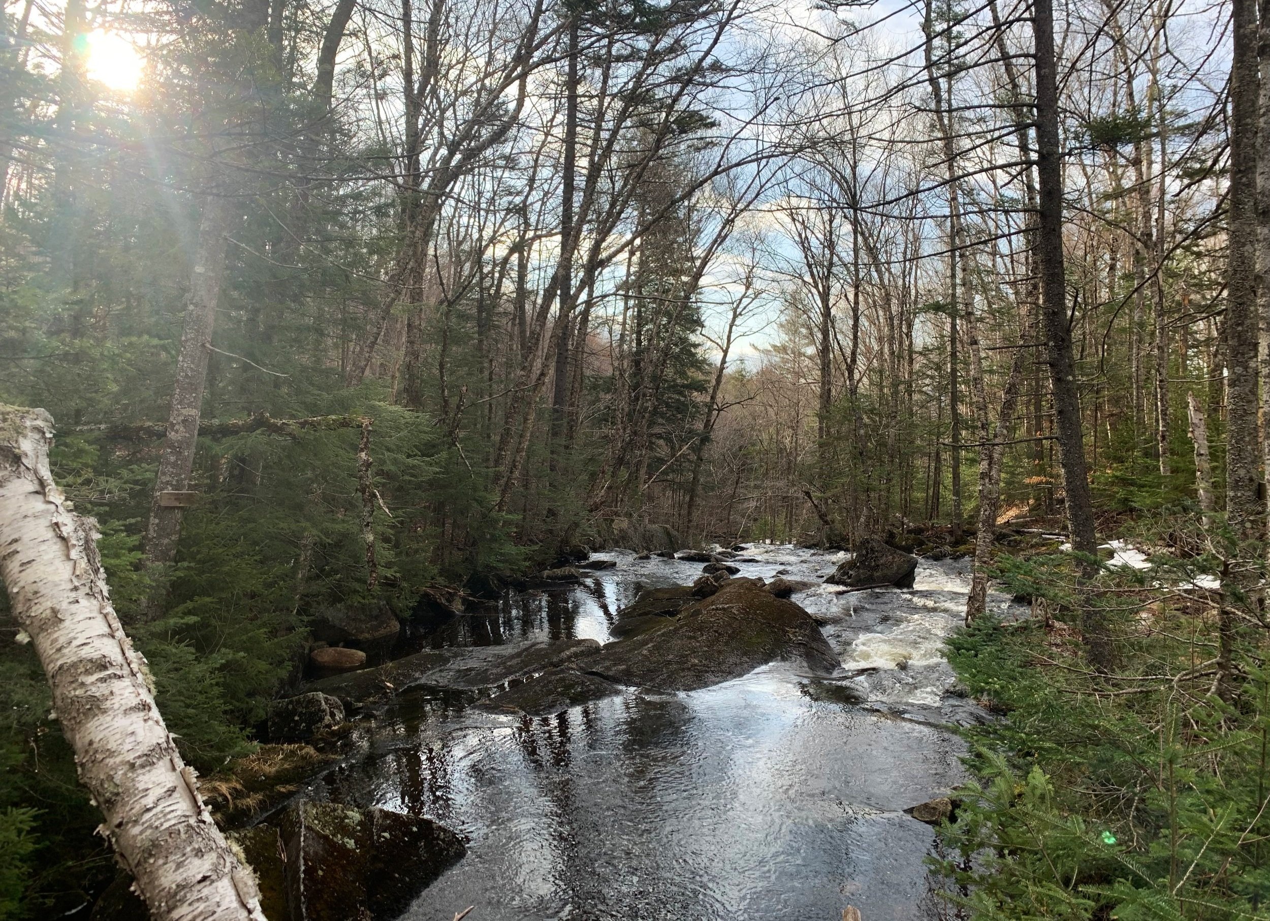
Morning along Brown Brook
Departing the trailhead at 7:04am, I was back to wearing layers and mittens in the 37° morning air; with trail running shoes on my feet I hoped for some quicker miles to offset the lengthy southern approach to the Mt Kineo ridge. Initially trekking on the Three Ponds Trail for brief 0.1-mile stretch, I was relieved to be atop a hardpacked dirt surface - there was some nearby water and a small crossing but the trail itself was pleasant and mostly dry.
Veering north at the first junction, I first turned right onto the relatively newer stretch of the Mount Kineo Trail which tracks east of Black Hill. Gently rolling over low hills and crossing several small brooks atop rocks and boulders, the first 1.0-mile of trail felt just right - very happy to be back on dirt and rock, leaping over roots and small obstacles while cruising a dry single track trail.

Snowmobile corridor of the Mount Kineo Trail
At the 1.0-mile point, the narrow trail merges onto an older section of logging road which doubles as a snowmobile trail; today, some minor snow and ice remained on the wooden bridges, but no chance I’d go head-to-head with a snowmachine, their trails closed for the season several days ago.
This stretch of wide pathway alternated between grass, dirt, mud and ice; while the ice was more of a solid-packed snow crust, I took every opportunity to utilize that surface as it didn’t collapse nearly as frequently as the small sections of boggy mud. I chose to continue along my wide, old logging road as opposed to dropping down to trek alongside the rushing waterflow of Brown Brook.

Passing alongside the beaver wetland
For a short 0.1-mile section, the road climbed steeply with decently dry footing before joining another snowmobile trail from the west and tapering off. While the Mt Kineo Trail continued northerly toward a swampy, beaver-built wetland area, I again opted to follow the snowmobile path, alternating from a surface of grippy snow and ice to fairly solid earth. The wide road made another short climb before gradually leveling off and descending toward the wetlands.
At 0.4-miles from departing the narrow hiking path of the old Mt Kineo Trail, it and the logging road rejoin as the yellow-blazed path emerges from the forest - this junction is very easy to miss, I only caught it on the return trek but had been looking for the merge from both directions.

Back on the narrow footpath of the Mount Kineo Trail
For the first half of the next 0.7-mile section, the beaver wetland is visible off to the west and a very good yet restricted view in that direction can be had from atop a section of bridge which spans a Brown Brook tributary. During the remaining length before reaching the next junction I was peering down into a very open, flat tract of land for any wildlife but perhaps my jingling bear bell alerted them to my presence.
At the junction, the snowmobile paths diverge, following my yellow blazes I continued to follow the wide path as it swings east/southeast and gains slight elevation. At 1,870’ the Mount Kineo Trail finally diverges from the soggy snowmobile highway and begins its approach as the ridgeline becomes visible in the near distance.

Becoming rocky along the south-facing mountainside
Overall this stretch of trail was extremely pleasant to meander; while I think its safe to claim this section of trail does not see much winter traffic with snowmobile roads encompassing half of the approach, the amount of downed branches and fallen debris was far to much for me to tackle on my trek in; with that said, the pathway was still obvious, well marked and entirely easy to follow.
Initially, through more hardwood consisting of primarily beech of varying ages, as one ascends northeasterly along the slope, the canopy transitions to mostly spruce and fir. Around 2,080’, the soft earth even began retaining some of the snow pellets which had fallen overnight, making me glad to have remembered to add an old pair of Hillsound spikes to the gear stashed on my back.
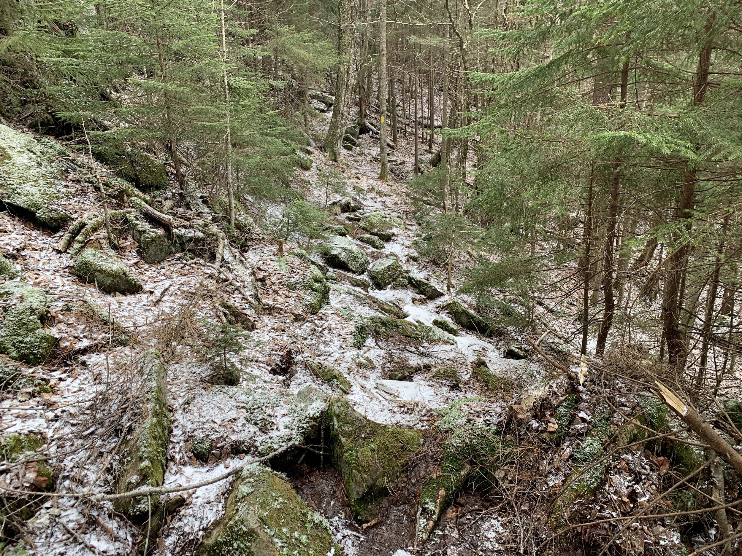
Nearing the Kineo ridgeline
Nearing the height-of-land and my departure from blazed trail, and path grew incrementally steep; footing became more slick with the fallen snow but I found it possible to step atop occasional rocks sticking out of the mountainside, as if they were steps. As the surrounding landscape began levelling off upon reaching the height-of-land - I instantly recognized the evergreen forest I had enjoyed romping through several weeks prior - this time with much less snow.
Eyeballing a line through the forest I departed the trail and began a pleasant trek rolling through the mostly open forest, meandering and weaving around or over small patches of light blowdown while trying to tread lightly. While descending more than climbing I quickly reached a low col which contained several inches of snow, some supportive while other patches disintegrated underfoot.

Remaining snowpack along the ridgeline
When not in low areas or beneath a dense forest canopy of evergreen boughs it was possible to remain on solid ground, only several short stretches could have truly benefitted from snowshoes, my Hillsound spikes even went for a ride as the forest floor provided enough traction all morning.
I began finding blue double-blazes once reaching 0.9-mile west from the Mount Kineo Trail. While atop the false summit I pondered what these markings could have been, initially I thought a property boundary, then I wondered if someone actually marked a path to the trailless summit. Once I had descended into the very open hardwood-filled col which lay between the false summit and the East Kineo landmass, I found a grey survey/marking wand and shortly after a yellow-blazed snowmobile path - perhaps the blazes were plotting the course of the snowmobile path? I suppose the answer may remain elusive.

Mysterious snowmobile path on East Kineo
While this narrow snowmobile path was not featured on any maps that I had observed, I was surprised to see it marked with yellow paint blazes as if it were a hiking trail. As it began meandering east - the direction I had been bushwhacking, I happily took it for a spin to see how much ground I could make up atop the frozen surface.
The path rolled up and over rocks, through beautiful mossy areas and contained much water flowing underfoot, most waterways were simply hopped from one side of snowy roadbed to the other, occasionally a foot dipped into the 2,810’ water; knowing I had several changes of socks and plastic bags if my feet got cold, I pressed on growing ever closer to the summit.
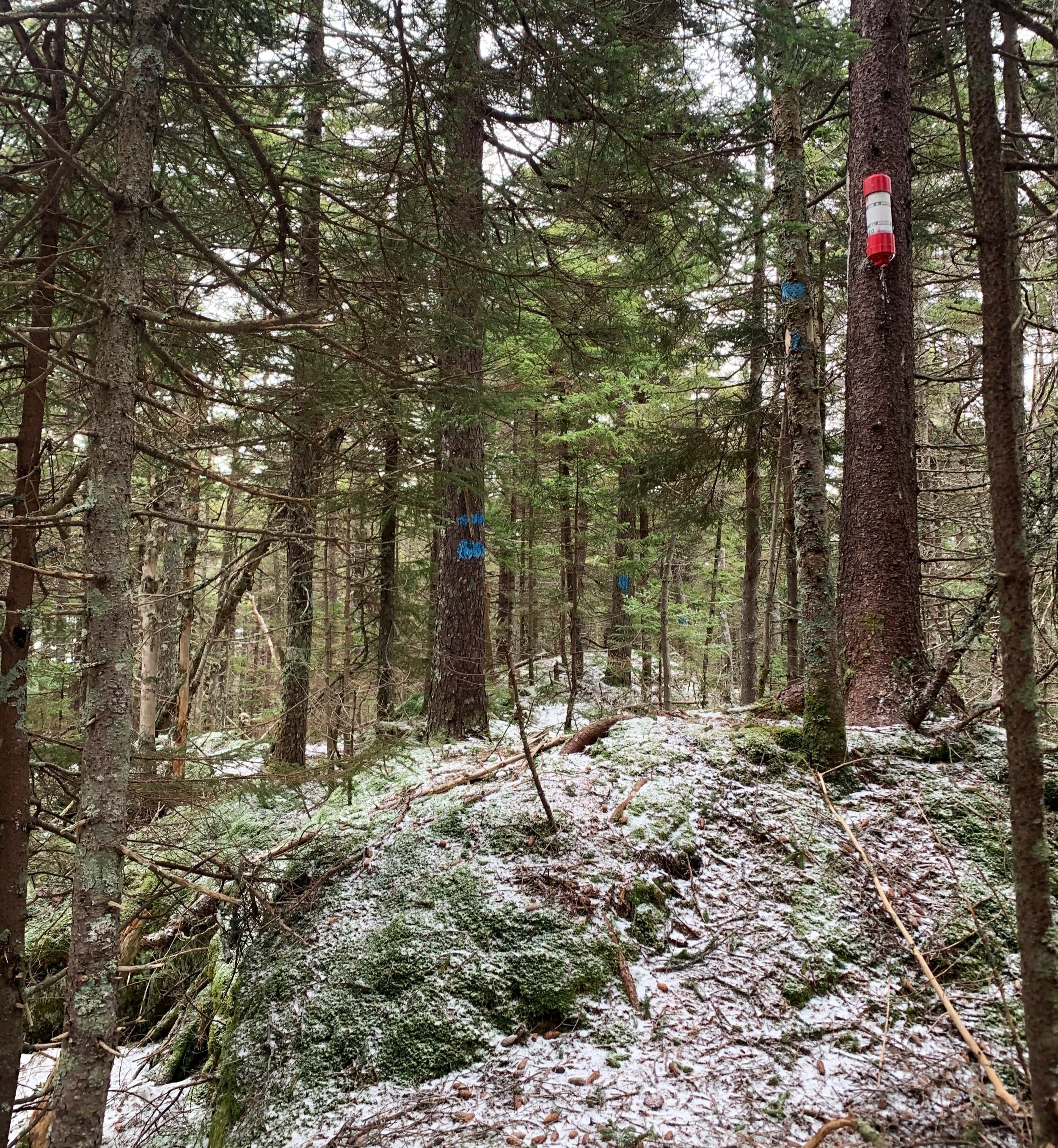
Mysterious blue double-blazes littering the forest
I began to wonder just how close the wide path would come to the actual summit as I had heard reports of hikers following snowmobile trails but assumed they lay much lower on the mountainside. Somewhere around 2,920’ I found the path I had been following begin to swing more northerly and losing elevation, this was my que to disembark the blazed path and re-enter the trailless forest.
Over a few brief scrambles utilizing sturdy roots and tree bases for handholds I hauled myself nearer to the summit. Once the high point was insight I trekked down a short, narrow ridgeline which had the blue double-blazes in various directions, one of the blazed trees even featured a numbered tree tag, which only added to the mystery.

Bushwhacking off the Kineo ridge
Happy enough to reach my summit, I signed in and read the first few pages of the register notebook, even finding Ed Hawkins’ name scribed in the end cap of the canister - he seems to be everywhere in these woods, usually with candy in hand.
Once I had a good stay at the East Kineo summit I worked to retrace my steps but simply trekked in the direction where I knew the snowmobile path could be found. Short, quick steps helped to not punch through the remaining hardpacked snow and ice surface, before long at all I had bounced down the 0.5-mile back to the deep col.

Back on the snowmobile corridor
Here, I weighed my options: continue along this yellow-blazed path to see if it met back up with the Mt Kineo Trail (it had been heading that direction anyway), re-enter the woods atop the ridgeline to bushwhack the 0.9-mile back to marked trail (not an option I was truly considering), or lose elevation as quickly as possible by bushwhacking south/southwest off the ridge to eventually join a snowmobile corridor running along Buzzell Brook.
I settled on the latter option, which I had planned in my mind early on once finding the remaining snowpack atop the ridgeline, I wanted to get back to the warmer, lower elevation and a bare forest floor quickly. It wasn’t hard to pick a mellow route through the primarily hardwood forest along the southern slope, occasionally I ran into bands of rocks - the most treacherous of which were boulders covered in a fine layer of moss and slime.

Ascending Black Hill
Overall the descent was easy, picking my way atop fallen leaves and stepping over sticks and small downed trees. Recent moose activity certainly picked up as the land neared flat and I reached the bottom of the slope, once finding a way to cross a small but wide brook I stepped foot onto the snowmobile corridor which would guide me back to the Mt Kineo junction of earlier.
With about 2.0-miles to trek atop the soggy snowmobile pathway, I still think this saved much time and anguish had I stayed on the ridgetop. To reach familiar trail and make my exit I only had to re-climb ~620’, which offered a fine chance for a snack as I auto-piloted my way uphill on the wide path.

Black Hill summit
As the grade leveled off and began to drop once again the pace could be picked up, almost performing a shuffle of sorts across the landscape as to tread lightly atop the soggy soil, the technique seemed to work well, only sinking in mud once. Glancing at my watch, it was only 11:30am; snow was softly falling around but I opted to jump on the chance to visit Black Hill.
Once again departing the blazed snowmobile path I turned to head off-trail in a due southwesterly direction, toward the 2,135’ summit. Overall the ascent was easy on this side of the mountain, that’s not to say it was not steep - creating my own “trad gear” climb, I hooked hands onto sturdy beech tree bases to gain good footing and slowly haul myself upslope.
The terrain was very unique and interesting for such a low peak; on the ascent I crossed a ravine which had massive bare rocks jutting out, finally around 2,000’ the forest transitioned into primarily one of conifer - a very beautiful mountaintop that I was not expecting!

Descending Black Hill
The orange-blazed salsa jar was easy to spot even amidst a sea of blowdown wrapping around the high point. I took a moment to register my ascent before taking a tea break and enjoy my surroundings. Opting to descend southeast to pick up the more narrow Mt Kineo Trail, I found no fewer than three bands of exposed rocks which spilled out onto a flat floor of hardwood, as if resembling steps in the mountainside. The boulders were often covered in a dense layer of fallen leaves and hid deep crevasses and voids well.
Once back on the familiar footway, it was even more satisfying to end my trek with a slow trail run back to my car; over rocks and roots, leaping over small waterways. While this had been a fantastic and very productive winter of exploration and bushwhacking to new places, I was very happy to have springtime and a bare forest floor once again.
Overall stats for the day:
12.55-miles
5hr 11 minutes
4,281’ elevation gain
Mt Kineo East Peak - 2,981’
Black Hill - 2,135’