
North + South Doublehead Mountains
With its fine views facing the mighty Presidential Range out the front of the shelter and the Mountain Pond, Baldface and Royce ranges from the east-facing ledges, North Baldface would, perhaps make for a fine sunset hike destination. However, with the 8-person cabin resting atop its pinnacle, unless you find yourself a resident of the Doublehead Cabin for the evening, the west-facing ledges atop its southern twin, South Doublehead, may make for a better perch from which to watch the orange, pink, blue and purple pastels streak the mountain-filled skyline as another beautiful day comes to a close.
These two connected peaks, located just outside of Jackson, NH, toward the east, offer very nice options for hiking an out-and-back trail; but, with so much forest and scenery to absorb, most prefer to trek the loop, visiting both beautiful destinations.
Departing the Doublehead Trailhead
While North Doublehead occupies the 29th highest spot on the New Hampshire - 52 With A View list, the slightly shorter South Doublehead rivals North thanks to its remoteness and lack of USFS cabin amenities atop its summit and more panoramic, westerly views.
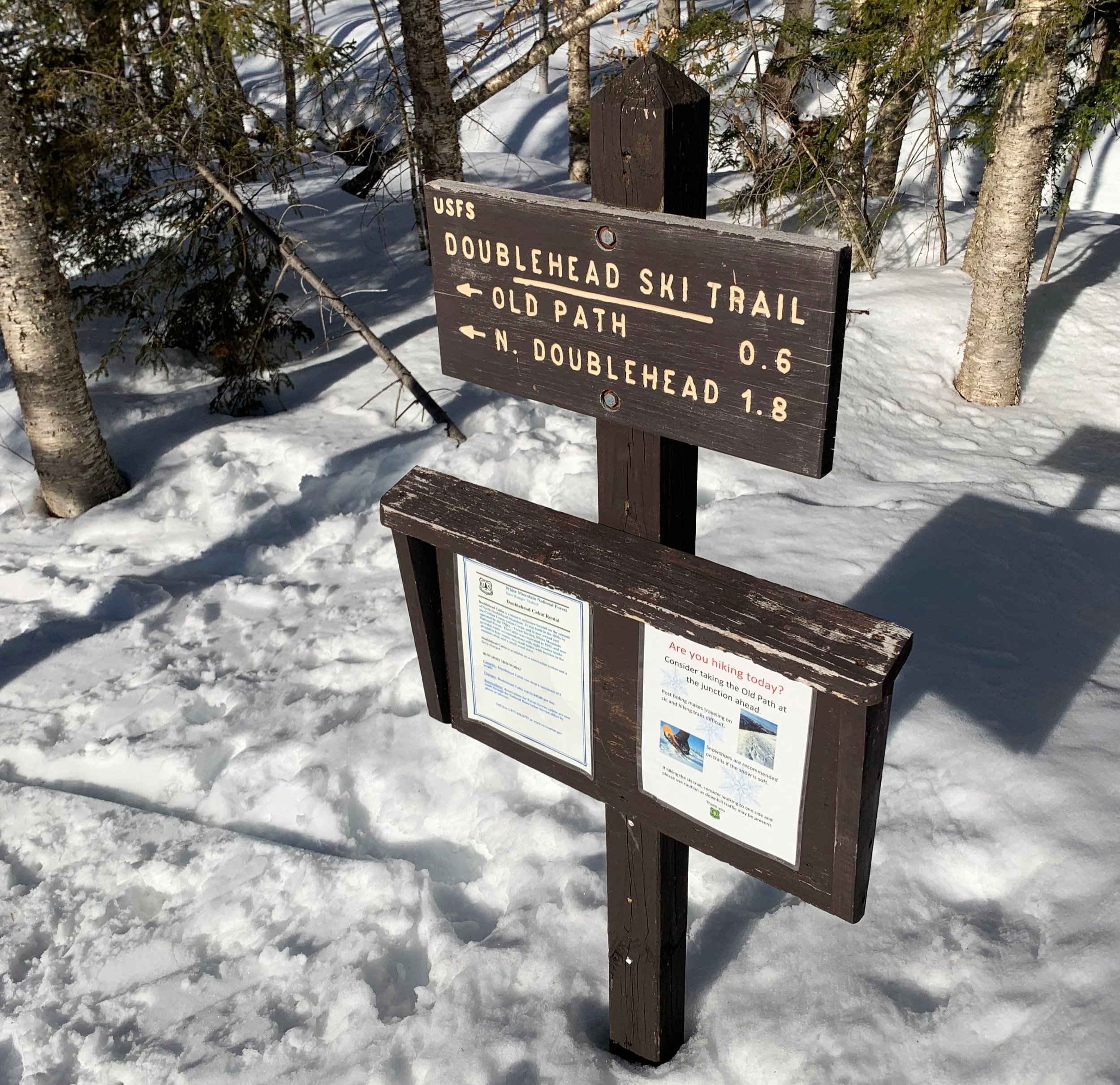
While there are several options in which to ascend these mountains - the New Path begins slightly to the south along Dundee Road and ascends directly to the southern mountaintop. With the option to make a lollipop-shaped loop out of our hike, we began at the Doublehead Ski Trail lot which was newly opened in 2017 and offers a brief relocation of the initial 0.3-mile stretch of trail.

Doublehead Ski Trail
As it is still winter, the lot was thankfully plowed, yet had several inches of frozen slush from several days of freeze/thaw cycles; perhaps 15-20 vehicles could still park comfortably.
Almost immediately, the trail passes over a small tributary to the Great Brook by way of wooden bridge, which had ~3’ of packed powder atop from ski and snowshoe traffic - even as Spring is fast approaching Winter still holds tight here in the mountains.
Before long the old trail cuts in on the left but clearly nature is trying to reclaim its land as shoots of small growth poke up through the thick snow, the old section of trail and parking lot have both reportedly been decommissioned.

Junction atop North Doublehead
The wide trail gradually ascends through open hardwood dominated by birch and beech, over humps created by descending ski turns; for the most part, snowshoes and bare boots respectfully occupy the outer areas of trail. In 0.5-miles the trails split - the Doublehead Ski Trail continues left while the Old Trail veers right, ascending steeply toward the col between North and South Doublehead Mountains.
As the trail enters the red blazed WMNF boundary line, it hops over several open streams and waterways, evidently skiers take to the woods to skirt around these wet patches. After passing the 2,300’ point, spruce and fir begin to dot the forest canopy, growing thicker as one ascends.

Back of Doublehead Cabin
The Ski Trail grows steeper further up the mountainside, ascending by switchbacks along its spruce-covered western slope. Reaching the final ascent toward the mountaintop, a beautiful view out to a very frosty Mount Washington with the Gulf of Slides - its ravine appearing to have been shredded by giant claws.
Cresting out atop North Doublehead, the Old Path is signed at the junction and continues south, while the 1932 USFS built Doublehead Cabin stands on the left. Out back, behind the cabin, hikers can find the local privy, while a short spur path leads beyond, to a ledgy area offering a stunning panorama toward Maine and other points east.

Easterly views from North Doublehead Mtn
The view from the front of the cabin appears to have been improved (recut perhaps?) since I had visited three years ago, or at least from what I remembered; a similar view to the backdrop while ascending just moments earlier, Mount Washington and the Presidential Range are nicely framed by conifer foliage.
Descending steeply for 0.2-miles, and with South Doublehead in sight most of the way, the Old Path tears down the southern shoulder of the North peak to meet in the col amidst young, spindly growth.

Presidential Range from North Doublehead Mtn
To the right, the Old Path descends back toward the Ski Trail parking lot where we began; here, the New Path merges in on the left, leading 0.2-miles to the summit of South Doublehead and its open, rocky ledges.
Once atop the New Path, a short spur trail leads to the open lookouts while the main path continues briefly before veering off to the right - the high point of the mountain is marked on maps as being just beyond this second junction while the trail rolls along several small humps.
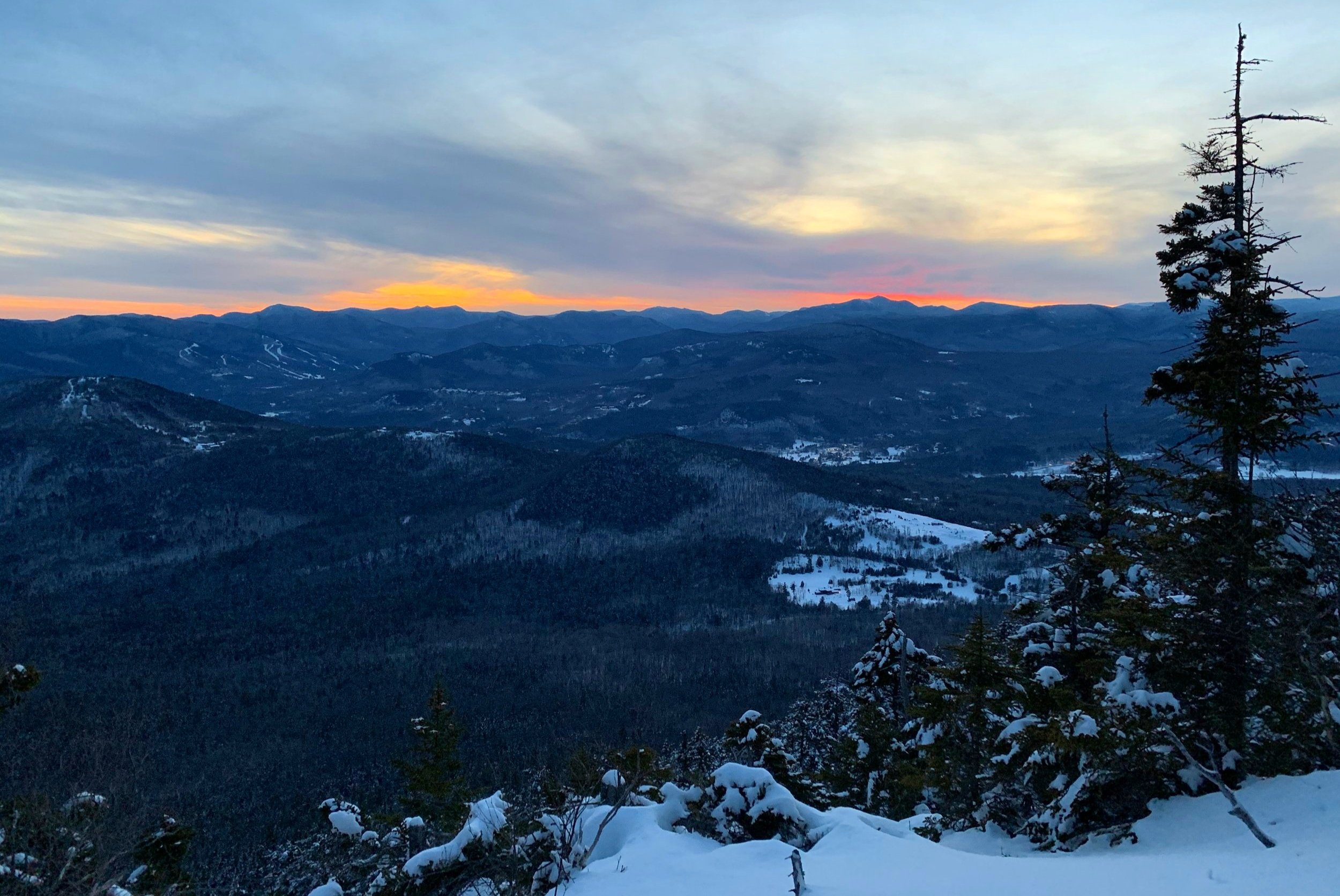
Sunset from South Doublehead; ascent: Feb. 15th, 2020
Retracing our steps back down the northern shoulder of South Doublehead, back to the junction, the Old Path swings west, descending the mountains and returning to the Dundee Road trailhead. All the while, through a beautiful stand of mature spruce, one can look far into the distance down the steep grade. Today, a deeply packed snowshoe trench meandered picturesquely between the open spruce as the warming sun grew low on the horizon ahead.
After 0.5-miles and several small swings in the trail to reduce the pitch, the Old Path meets back up with the Doublehead Ski Trail, thus completing our loop for the familiar 0.5-mile low-grade descent back to the trailhead.

Descending the Old Path
As it was winter, the packed ski/snowshoe track clearly continued toward the left, but care should be taken to follow the blue-arrow markers back to the newer trailhead.
The loop makes for a great trek, low-mileage with plenty of rewarding views and spots to pull over for an enjoyable break while enroute. The ledges atop either mountain beckons the hiker to take a pause and just let the world unfold around - listening to the birds, watching the leaves rustle in the gentle breeze or simply observing the grand vistas of the eastern White Mountains.
Overall stats for the day:
3.94-miles
2hr 15 minutes
1,988’ elevation gain