
Bridal Veil Falls: Franconia
For dozens of mornings we had driven past this dirt road called Coppermine but had no idea about what natural gems lay just beyond its semi-private entrance.
Looking at an old map one day I came across a destination on the western side of Cannon Mountain in Franconia labeled “Bridal Veil Falls”, it didn’t take much research online to find out just how and why it was so popular. The short hike got filed away in my memory bank to be recalled anytime I just needed a quick walk in the nearby forest.
Yesterday was just that, a late start and several inches of fresh powder brought the 5-mile out-and-back to the forefront of my attention. A quick online search will provide loads of information about this hike to the 80-foot waterfall but conveniently we have the Waterfalls of the White Mountains by Bruce and Doreen Bolnick on a bookshelf, its’ pages contain a wealth of information.

Coppermine Trailhead
The trailhead is located off Rt 116 just south of the Franconia Inn & airport, on Coppermine Road. Shortly after turning onto Coppermine Road, proper USFS (WMNF) signage can be found on the left, locating the hiker parking lot which can host 10+ vehicles.
Once on the road walk en route to the main trail system, Beechwood lane veers left while the hiker path continues on the right with signs high in the trees announcing “Foot Travel Only”. At 0.3-miles a hiker sign is found which denotes which direction to continue. This section is an old road, which, up until 1987 was navigable by automobile for the first 0.8-miles and now it’s all by foot to relish in the big white pines, hemlock and birch stands. The path follows yellow blazes and is well marked, easy to follow for its entirety.
Reaching the 0.8-mile mark from the trail head we came across the brown and yellow USFS signage for the Coppermine Shelter and Bridal Veil Falls, looking at the mileage on the sign had us questioning if perhaps it was meant to be placed further back, near the hiker parking lot.

Along the old road, Coppermine Trail
While hiking this in wintertime was beautiful and incredibly peaceful, I will certainly be making a return trek in warmer months to find the plaque located on one of the boulders along the edge of the Coppermine Brook, which traces a majority of the trail. Much history can be found about this (which I looked into mostly after the hike), but to keep it short, Betty Davis had the plaque placed after becoming lost from a hiking group and requiring assistance from a gentleman at Peckett’s Inn whom she later married. Sadly, the rescuer, Arthur Farnsworth, died only a few years later from apparent head trauma.
Back on trail, we continued to trace the left side of Coppermine Brook, ascending gradually. After several slightly steeper sections we crested into a lovely open hardwood tract of land for about 0.5-miles which brought us to the bridged crossing of Coppermine Brook.
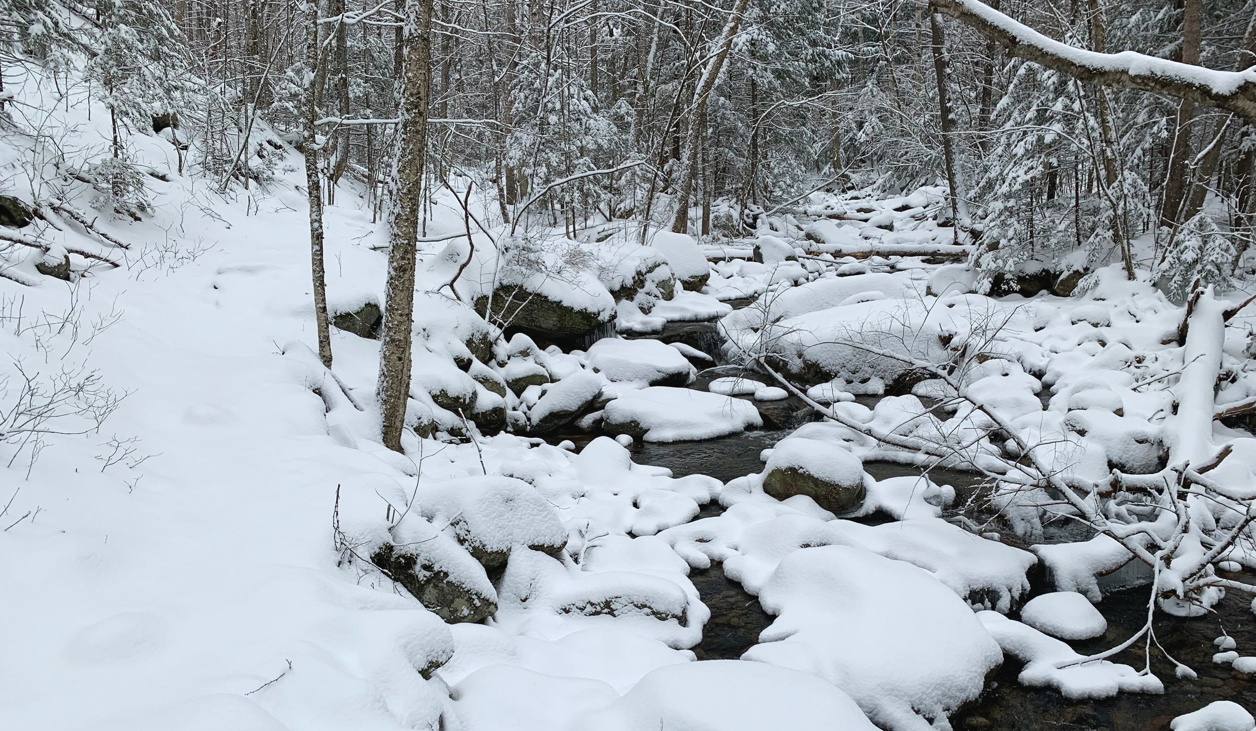
Coppermine Trail along Coppermine Brook
Just after crossing the brook we walked past what looked like a steep old logging road which nature was trying to reclaim; old maps suggested it is likely the old section of the Coppermine ski trail which was abandoned around the time the Cannon Tramway was put into use.
According to 1940’s and ‘50’s maps, this old ski trail came from the south, toward the present day Kinsman Ridge Trail and swung above the current falls location and connected with the Taft ski trail and later to the Tucker Brook ski trail on Mittersill Peak, a 3,617’ sub-peak located on the northwestern ridge of Cannon Mt.
Not far up ahead the Coppermine Shelter is found while the trail continues to follow yellow blazes over a small cascade into a pool, through a narrow aisle of conifers henceforth to the main falls.

Bridal Veil Falls
While the guidebooks suggest this falls is a total of 80’ in drop, this is over several levels of falls with the main event encompassing about 35’ of the vertical descent. Nonetheless, the falls (at least in winter) were still remarkable, as if frozen in time with the blue, yellow and grey ice draped elegantly over the granite; one section remained open for the viewer to bask in the sights and sounds of rushing water.
With great care we traipsed over what were certainly frozen pools at the base to gain a higher, better vantage of the panoramic vista - walking to the right side along the bank to ensure we remained on the thickest ice and deepest snow - a chilly dip this far out would be detrimental to any fun hike in the forest.
After carefully roaming around the falls and framing photographs we retreated to the shelter to drop packs, have snacks and rehydrate with some warm tea before beginning the 2.5-mile snowy walk back to our car, at least in this direction we had already broken trail.

Ice columns enroute to the main falls
While navigation was straightforward the Hillsound spikes we had donned to tackle the icy path below the fresh snow had been balling up with the 30° air temps, each rock presented a surface to kick off the balls underfoot before ankles became rocked and rolled - needless to say, as soon as we were clear of ice the spikes came off and the going got easier.
Passing our familiar landmarks, we trekked from hardwood back into hemlock groves and before long our giant white pine friends were back in sight.
This was a fantastic hike - easy ascending, beautifully desolate forests, a bit of interesting history and a mesmerizing waterfall to cap off the 2.5-mile jaunt. We certainly plan to come back in warmer weather and make use of the Coppermine Shelter with its firepit, nearby bubbling brook and towering rock wall amphitheater; certainly seems like a lovely spot to call home for a night!
Overall stats for the day:
4.8-miles
2hr 37min
1,411’ elevation gain
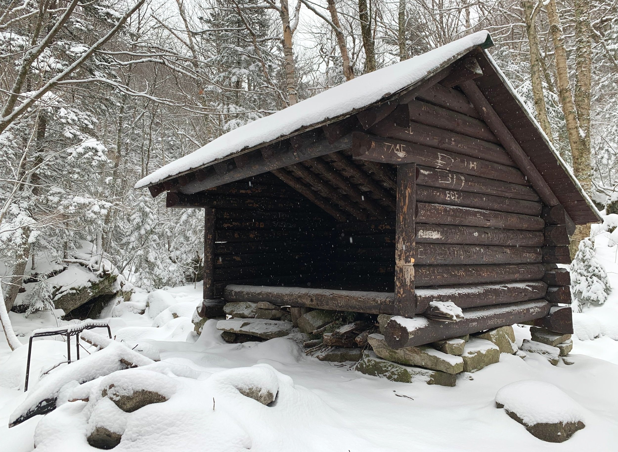
Coppermine Shelter