
Plymouth Mountain
With days of soggy weather on the horizon, my mountain and trail running comrade, Chris and I decided a sunrise hike would be a good idea before water-levels rise and trails get even sloppier with the springtime thaw still going full-swing. He had been to Plymouth Mountain countless times and knew the trail network well; with much anticipation, this would be my first jaunt along its soft trails and to ledgy vistas which I had yearned to visit.
From the northern trailhead along Old Hebron Road, we locked the car and began along the Fauver-Link Trail at 4:54am, hoping to be near the 2,193’ summit for the 5:47am sunrise. Passing Clay Brook early on, as well as several smaller tributaries - all crossings were relatively low but made easier still by stepping atop well-placed rocks - at 0.4-miles an old logging road, now Scenic View Drive is crossed as the main ascending trail now becomes the Sutherland Trail; primarily blazed yellow while the occasional, older blue-paint swatches can still be found.
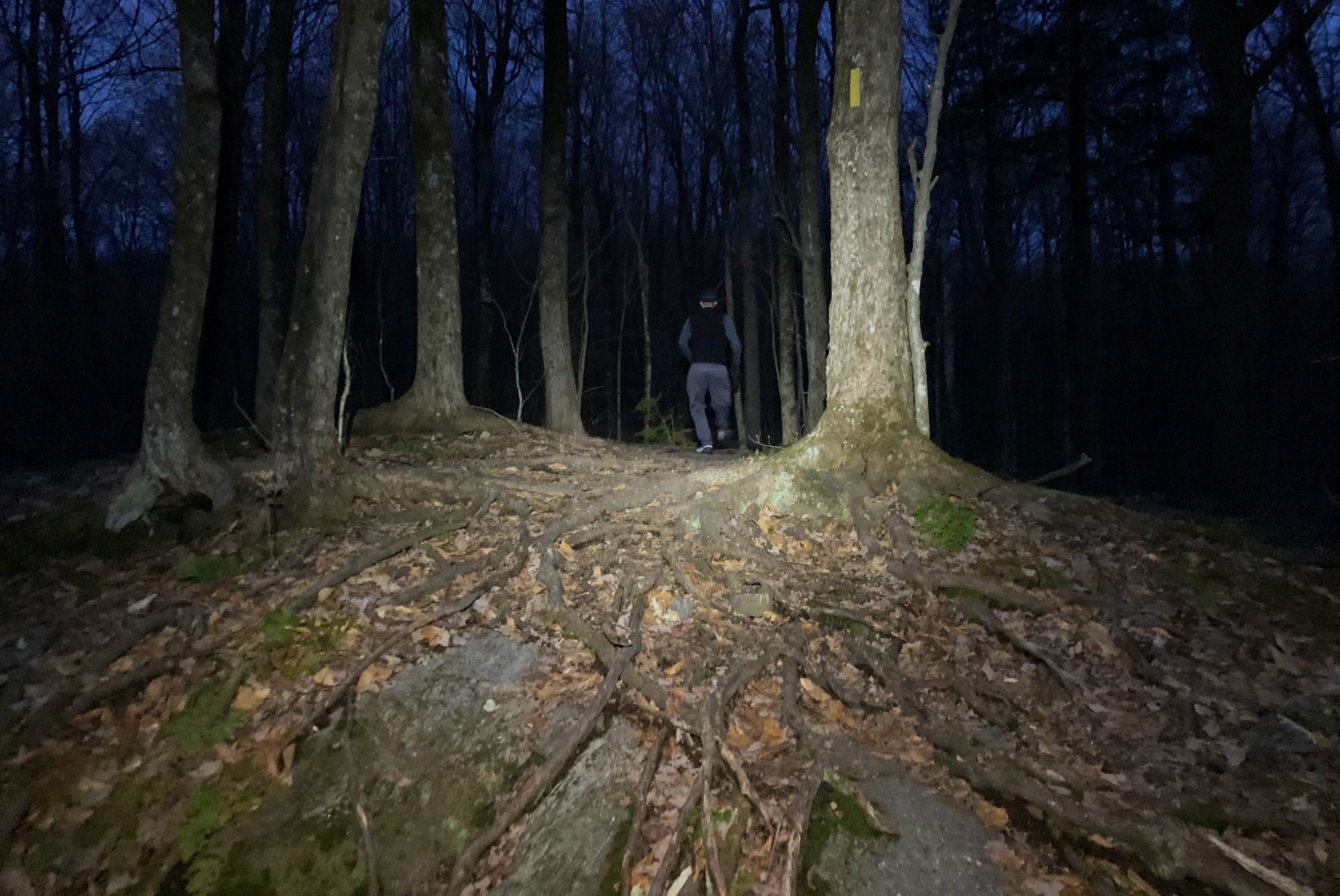
Early morning on Plymouth Mountain
Shortly back into the forest, the trail makes an abrupt southeasterly swing upslope as an old logging road enters. Between patches of hemlock and various other conifers, we rolled along the landscape through a relatively open mountainside which featured everything from soft dirt and fallen conifer needle trails to bare rock slabs in which to scramble; higher up the mountainside, the underfoot spiderweb-like network of bare roots began to show. Anticipation of what lay ahead grew as we could now get a glimpse of deep magenta, purple and nectarine-hues on the horizon - a skyfire sort of sunrise.
After zig-zagging our way along the northern ridge and skirting below a rocky knob just east of the trail, we soon came to the junction with Pike’s Peak, the northern sub-peak of Plymouth Mountain where we would later find glorious views from atop its bare summit ledges; but first, we were on a mission to find the east-facing ledges, atop which would provide the finest northeasterly views for this morning’s sunrise.
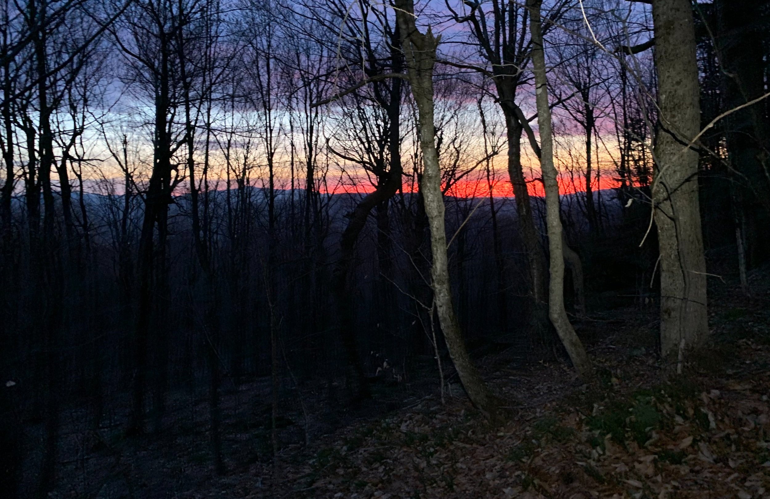
Skyfire on the horizon
Nearing ~2,050’, we diverged from the main path onto a “marked” herd path; while not terribly hard to follow, the mildly trodden trail is occasionally blazed with small rock cairns. Here, we tossed several downed branches off the pathway, making the trek hopefully a bit more pleasant for those who followed after us.
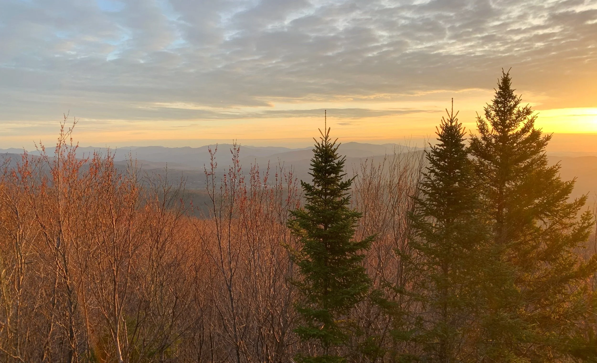
After descending slightly off the summit cone of Plymouth Mountain and meandering for about 0.2-mile, we finally emerged on a small 2-tiered rock-slab, ledgy area with picturesque views toward the Ossipee and Sandwich mountain ranges; slightly north of Larcom Mountain the glowing ball of sun began to emerge as the seconds ticked by.

Sunrise from the east ledges
Once photographs were taken and we had our fill of the orange, pink and blue pastel show across the sky, we retraced our steps back to the Sutherland Trail, took a right to descend the 0.2-mile back to the spur trail junction, for a brief rest atop Pike’s Peak was next on the agenda.
As the sun had now risen above the horizon, it began to illuminate through the forest canopy as if the hillside was aflame with the brightest white and yellow inferno. Reaching the open ledges atop Pike’s Peak, again, we were not disappointed. Nearby, several conifers rose up but were surrounded by a million red buds on the lower slope of hardwood trees - each bud seemingly reflecting and glowing bright by the low-angle morning rays.
Northerly views from Pike’s Peak
From here we could pick out some of our favorites: the low ridge of Carr Mountain to the left, followed by the nearby Stinson Mountain, Moosilauke and its South Peak came next, followed by the lower summits of the Hubbard Brook area; the Kinsman’s rose up while I could just make out the tower atop Cannon Mountain; across the void of Franconia Notch, Chris pointed out many of the higher peaks as Mt Liberty and Flume tapered toward the southern end of the Franconia Ridge like two Egyptian pyramids standing tall; many peaks became jumbled as we located the Scar Ridge, the Osceola’s and Tecumseh; a very white, seemingly faded Mount Washington rose up from behind Mt Carrigain and its Signal Ridge; our beautiful panoramic window through the trees ended with the Tripyramids and Sandwich Dome - what a reward for such a pleasant climb!

Following bare rock nearing the summit
Once we had our fill of the surrounding, golden-hued White Mountains we, again, retraced our steps and this time began south along the Sutherland Trail with the mountains high point our next destination. Beyond the short spur trail which led toward the eastern ledges, the trail now became increasingly rugged as we scrambled at times over bare granite which rose near-vertically out of the surrounding forest floor carpet.
Just prior to a westerly swing in the main path, the trail reaches a false summit, atop which a massive rock cairn can be found; if one wasn’t sure of higher ground looming nearby, this could surely be mistaken as the mountains high point; thanks to Chris knowing the area and the trails well, we proceeded on, toward the true summit of Plymouth Mountain.
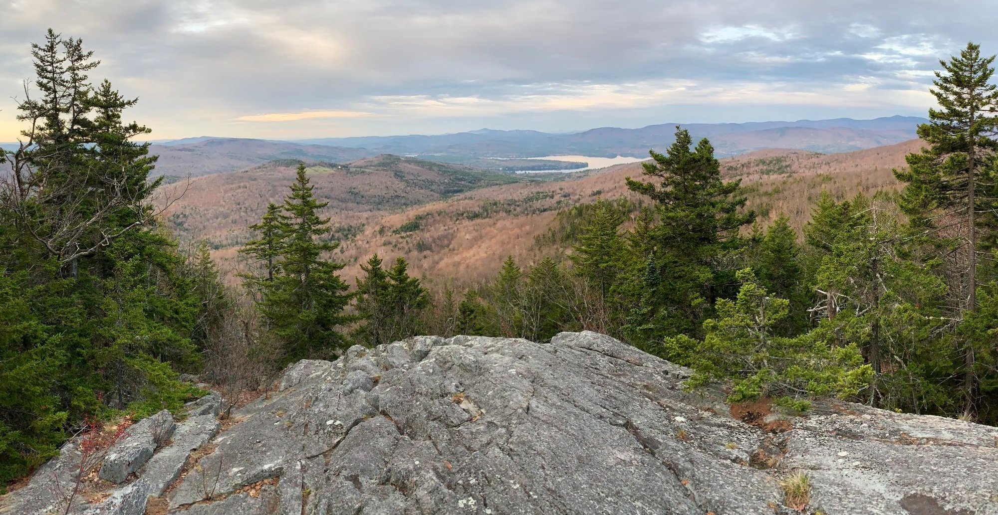
Southerly views toward Newfound Lake
From the actual 2,193’ summit of Plymouth Mountain, there are no views to be had, but we found a beautiful red-painted sign indicating the peak as well as several 1960’s USDA Forest Service benchmark discs placed in the bedrock. From here, we were on the prowl for the seldomly visited ledges from which fine southerly views to Newfound Lake can be had.
This path, while not terrifically difficult to follow either, does contain several seemingly random, meandering herd paths to various other rocky outcroppings; once we had continued far enough down off the summit cone we found what we were looking for. Most notable of this beautiful outlook was the southern Mount Kearsarge, Ragged Mountain with its northern-facing ski slopes and the cluster of peaks surrounding the open summit of Mount Cardigan.

Soggy section along the Plymouth Mountain Trail
Backtracking yet again toward the main trail, several options for a descent present themselves; the first of which would be to simply follow the Sutherland Trail back down the northern slope to the Fauver trailhead parking area; another option could be to descend by way of the Plymouth Mountain Trail to Pike Hill Road, if spotting cars was an option; otherwise, a 4.1-mile trek over the foot-traffic-only portion of Pike Hill Road could be utilized to make a loop, thus returning back to the Fauver Trailhead, as well.

Gazing toward the Southwest Peak
Descending the Plymouth Mountain Trail, one begins finding the old wooden, white with black wolf stencil trail markers from Camp Mowglis, apparently they have recently restarted trailwork and maintenance on this once partially abandoned section. Initially, meandering over a moss-carpeted conifer forest plateau, the trail soon turns into a highly eroded, wet and rocky logging road. Eventually crossing George’s Brook, the old road bisects Pike Hill Road as well as several other nearby forest and logging roads, which are repurposed into snowmobile paths during winter months.
Overall stats for the day:
4.54-miles
3hr 10 minutes
2,119’ elevation gain
Plymouth Mountain - 2,193’
Pike’s Peak - 2,146’

Summit benchmark disc